Enable Location

We need your location to show you interesting places around you

Discover nearby places

Find interesting locations and hidden gems around you

Precise directions

Get accurate directions and distances to places

Your location is never shared with other users. It's only used when you tap the location button.

Kurima Bridge

Log in to your account

Start exploring — it's free

Trusted by 63,590 travelers worldwide

Continue with Google
Continue with Apple
or

We will send you a code to connect

By continuing, you accept our Terms and Conditions and our Privacy Policy

Check your inbox

We've sent a pincode in your inbox. Please enter the code below.

Kurima Bridge
Discussion Reviews 2 Photos
6.4k Popularity

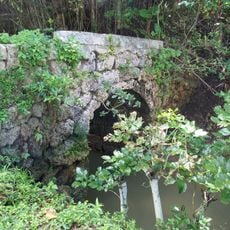
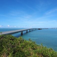
Kurima Bridge, Bridge structure in Miyakojima, Japan

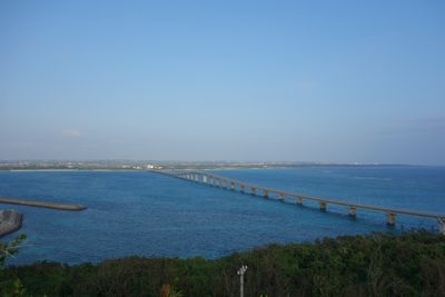
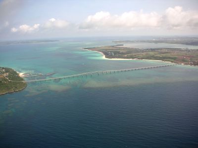
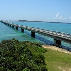
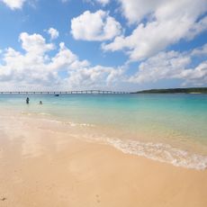
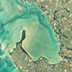
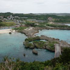
Kurima Bridge extends over 1,600 meters to connect Miyako Island and Kurima Island with a continuous roadway for traffic flow. The structure accommodates cars, bicycles, and pedestrians crossing above the shallow strait, where the water displays changing shades of blue and green.

The bridge opened in 1995, creating the first permanent land link between the two islands. This project fundamentally transformed how residents could travel and connect with the larger Miyako Island community.

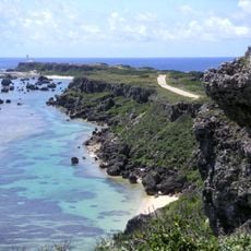
The bridge connects two communities and allows people to maintain relationships across the islands while keeping their local customs alive. Visitors can feel this living connection by crossing and observing how islanders move between their homes and daily activities on each side.

The bridge is accessible around the clock to all types of traffic and remains open for vehicles and pedestrians without restrictions. You can stop at the Kurima Ohashi Observatory to take photos or simply enjoy the water views from a designated vantage point.

The shallow waters beneath the bridge shift between different color tones depending on the time of day and sunlight, which makes it popular for photography. Sea turtles regularly pass through the strait below and can sometimes be spotted from the bridge railing.

The community of curious travelers

AroundUs brings together thousands of curated places, local tips, and hidden gems, enriched daily by 60,000 contributors worldwide.

Start exploring
Location
Inception
March 13, 1995
Official opening
March 13, 1995
GPS coordinates
24.72611,125.26444
Latest update
December 9, 2025 18:43
Reviews
Share your experience

No review yet

Discussions
Start a discussion...

No discussion yet

« Kurima Bridge - Bridge structure in Miyakojima, Japan » is provided by Around Us (aroundus.com). Images and texts are derived from Wikimedia project under a Creative Commons license. You are allowed to copy, distribute, and modify copies of this page, under the conditions set by the license, as long as this note is clearly visible.

Discover hidden gems everywhere you go!

From secret cafés to breathtaking viewpoints, skip the crowded tourist spots and find places that match your style. Our app makes it easy with voice search, smart filtering, route optimization, and insider tips from travelers worldwide. Download now for the complete mobile experience.

Around Us App Screenshot

A unique approach to discovering new places

Le Figaro

All the places worth exploring

France Info

A tailor-made excursion in just a few clicks

20 Minutes

Around Us
Travel Guide & Maps
Download

Send to your phone

QR Code
1

Open the camera app on your mobile.

2

Point at the QR code with your camera. A notification will appear.

3

Tap the notification to open the link.