Chest opened
+${chestReward.xp} XP
Explorer
NOUVEAU ×${chestReward.collectible.quantity}
tapez pour fermer
Chest locked

Open chests in the app

Around Us is built for your phone — chests unlock when you walk, explore and capture nearby places.

Enable Location

We need your location to show you interesting places around you

Discover nearby places

Find interesting locations and hidden gems around you

Precise directions

Get accurate directions and distances to places

Your location is never shared with other users. It's only used when you tap the location button.

Log in to your account

Start exploring — it's free

Trusted by 72,891 travelers worldwide

Continue with Google
Continue with Apple
or

We will send you a code to connect

By continuing, you accept our Terms and Conditions and our Privacy Policy

Check your inbox

We've sent a pincode in your inbox. Please enter the code below.

Monks Park
Discussion Reviews Photo
2.3k Popularity

Monks Park, Urban recreational park in northern Bristol, England.

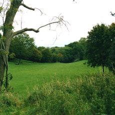
Monks Park is an urban recreational space in northern Bristol with open grassy areas, paved pathways, and various facilities for different activities. The site includes a children's playground with climbing structures and slides, basketball courts, and skateboarding areas.

The park takes its name from James Henry Monk, a 19th-century bishop of Gloucester and Bristol. Development of the site began in the 1930s.

The space functions as a neighborhood gathering spot where people come to play sports, use the equipment, and spend time outdoors with friends and family.

The park is accessible from several roads including Kenmore Drive, Lydington Road, and Biddlestone Road, which offer multiple entry points. Opening is daily throughout the week.

The park sits within a residential area of semi-detached homes and occupies the highest elevation point in the city. This location offers views across the wider surroundings.

The community of curious travelers

AroundUs brings together thousands of curated places, local tips, and hidden gems, enriched daily by 60,000 contributors worldwide.

Start exploring
Location
GPS coordinates
51.49977,-2.58516
Latest update
December 13, 2025 12:24
Around this place
The Dower House
United Kingdom

The Dower House

2.9 km
MoD Abbey Wood
United Kingdom

MoD Abbey Wood

1.8 km
Aerospace Bristol
United Kingdom

Aerospace Bristol

2.6 km
Stoke Park
United Kingdom

Stoke Park

2.3 km
Purdown BT Tower
United Kingdom

Purdown BT Tower

2.2 km
St Ursula's School
United Kingdom

St Ursula's School

2.5 km
Frome Valley Walkway
United Kingdom

Frome Valley Walkway

3.1 km
St Werburgh's Church, Bristol
United Kingdom

St Werburgh's Church, Bristol

3.2 km
Church of the Holy Trinity with St Edmund
United Kingdom

Church of the Holy Trinity with St Edmund

1.4 km
Church of Holy Trinity, Stapleton
United Kingdom

Church of Holy Trinity, Stapleton

2.9 km
Westbury College Gatehouse
United Kingdom

Westbury College Gatehouse

2.3 km
Redland Green
United Kingdom

Redland Green

3.2 km
The Old Lodge
United Kingdom

The Old Lodge

2.2 km
Church of St Alban
United Kingdom

Church of St Alban

3.2 km
Church of St Peter
United Kingdom

Church of St Peter

1.4 km
Wickham Bridge
United Kingdom

Wickham Bridge

3.1 km
Müllers & The George Müller Museum
United Kingdom

Müllers & The George Müller Museum

2.4 km
Two Pillars
United Kingdom

Two Pillars

3.1 km
Public Lavatory On South East Corner Of Horfield Common
United Kingdom

Public Lavatory On South East Corner Of Horfield Common

1.2 km
Milestone At St 5718 7756 Approximately 10 Metres North East Of Trym Lodge
United Kingdom

Milestone At St 5718 7756 Approximately 10 Metres North East Of Trym Lodge

2.3 km
Brunel House Muller Homes (City Of Bristol College)
United Kingdom

Brunel House Muller Homes (City Of Bristol College)

2.4 km
Westbury On Trym War Memorial
United Kingdom

Westbury On Trym War Memorial

2.4 km
Rustic Lodge, Blaise Castle Estate
United Kingdom

Rustic Lodge, Blaise Castle Estate

3.1 km
Henbury Hill Lodge, Blaise Castle Estate
United Kingdom

Henbury Hill Lodge, Blaise Castle Estate

2.8 km
Bristol North Baths
United Kingdom

Bristol North Baths

2.8 km
Milestone At St 6127 7590, Approximately 40 Metres North East Of South Entrance To Purdown Hospital
United Kingdom

Milestone At St 6127 7590, Approximately 40 Metres North East Of South Entrance To Purdown Hospital

2.8 km
Milestone, N corner St. Thersa's churchyard
United Kingdom

Milestone, N corner St. Thersa's churchyard

771 m
Milestone, Westbury Road, S of Henleaze Road, on Common
United Kingdom

Milestone, Westbury Road, S of Henleaze Road, on Common

3 km
Show the full map
Reviews
Share your experience

No review yet

Discussions
Start a discussion...

No discussion yet

« Monks Park - Urban recreational park in northern Bristol, England » is provided by Around Us (aroundus.com). Images and texts are derived from Wikimedia project under a Creative Commons license. You are allowed to copy, distribute, and modify copies of this page, under the conditions set by the license, as long as this note is clearly visible.

Discover hidden gems everywhere you go!

From secret cafés to breathtaking viewpoints, skip the crowded tourist spots and find places that match your style. Our app makes it easy with voice search, smart filtering, route optimization, and insider tips from travelers worldwide. Download now for the complete mobile experience.

Around Us App Screenshot

A unique approach to discovering new places

Le Figaro

All the places worth exploring

France Info

A tailor-made excursion in just a few clicks

20 Minutes

Around Us
Travel Guide & Maps
Download

Send to your phone

QR Code
1

Open the camera app on your mobile.

2

Point at the QR code with your camera. A notification will appear.

3

Tap the notification to open the link.