Enable Location

We need your location to show you interesting places around you

Discover nearby places

Find interesting locations and hidden gems around you

Precise directions

Get accurate directions and distances to places

Your location is never shared with other users. It's only used when you tap the location button.

Strines Reservoir

Log in to your account

Start exploring — it's free

Trusted by 62,563 travelers worldwide

Continue with Google
Continue with Apple
or

We will send you a code to connect

By continuing, you accept our Terms and Conditions and our Privacy Policy

Check your inbox

We've sent a pincode in your inbox. Please enter the code below.

Strines Reservoir

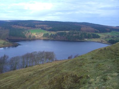
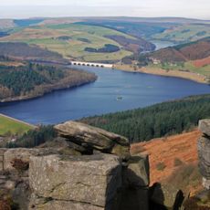
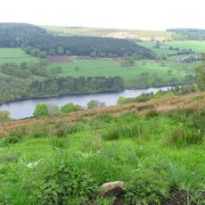
Strines Reservoir, lake in the United Kingdom

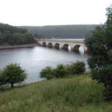
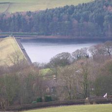
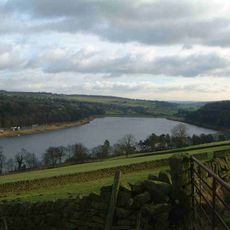
Strines Reservoir is a large water storage area in South Yorkshire surrounded by green woodlands and moors, featuring a straight stone and concrete dam wall holding back thousands of gallons. A sturdy steel footbridge crosses the spillway at the base, allowing excess water to flow safely away during heavy rainfall.

Built in the late 1800s to supply clean water to Sheffield as the city expanded beyond the capacity of older smaller dams, the reservoir was part of a major effort to modernize the water system. The construction represented a significant infrastructure investment to support the growing population.

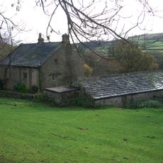
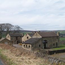
The name Strines comes from the 13th century and refers to a small stream flowing from the moors. Visitors can still see Brogging House, an old building that once housed workers managing the reservoir, offering a tangible connection to the place's working past.

The area is easily reached by car or bicycle via country lanes, with parking available near walking paths around the water. Visit during daylight hours when the light makes the surroundings warm and welcoming.

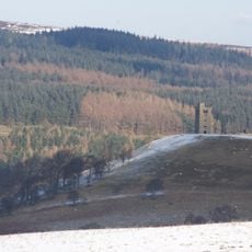
Boot's Folly, a tower-like structure built in 1927 from leftover stones, rises about 45 feet on the hillside above the reservoir and offers surprising views of the surrounding landscape. Local legend suggests it may have been built by a builder named Charles Boot, making it an unexpected historical find for visitors exploring the area.

The community of curious travelers

AroundUs brings together thousands of curated places, local tips, and hidden gems, enriched daily by 60,000 contributors worldwide.

Start exploring
Location
Elevation above the sea
242 m
GPS coordinates
53.40990,-1.65570
Latest update
February 9, 2026 08:23
Around this place
Ladybower Reservoir
United Kingdom

Ladybower Reservoir

5 km
Dale Dike Reservoir
United Kingdom

Dale Dike Reservoir

1.3 km
Hordron Edge stone circle
United Kingdom

Hordron Edge stone circle

3.8 km
Church of St Nicholas, Bradfield
United Kingdom

Church of St Nicholas, Bradfield

4.3 km
Sugworth Hall
United Kingdom

Sugworth Hall

821 m
Hallfield House
United Kingdom

Hallfield House

1.2 km
Fair House Farmhouse
United Kingdom

Fair House Farmhouse

3.4 km
Moscar Cross
United Kingdom

Moscar Cross

2.1 km
Derwent Woodlands War Memorial
United Kingdom

Derwent Woodlands War Memorial

5.2 km
Sugworth Tower
United Kingdom

Sugworth Tower

493 m
Edgefield Monument
United Kingdom

Edgefield Monument

2.6 km
Ashopton Viaduct
United Kingdom

Ashopton Viaduct

5.4 km
Milepost Approximately 80 Metres West Of Driveway To Moscar Cross Farm
United Kingdom

Milepost Approximately 80 Metres West Of Driveway To Moscar Cross Farm

2.4 km
Fox Holes Farmhouse, Attached Farmbuildings And Linking Walls
United Kingdom

Fox Holes Farmhouse, Attached Farmbuildings And Linking Walls

3.5 km
Mile Post Approximately 90 Metres West Of Driveway To Swinglee Ford
United Kingdom

Mile Post Approximately 90 Metres West Of Driveway To Swinglee Ford

4.5 km
Take Off Stone Approx 85 Metres To North Of Strines Public House
United Kingdom

Take Off Stone Approx 85 Metres To North Of Strines Public House

758 m
Guide Pillar At Junction With Onesmoor Road On West Side Of Junction
United Kingdom

Guide Pillar At Junction With Onesmoor Road On West Side Of Junction

5.7 km
Guide Pillar At Junction With Mortimer Road On South Side Of Junction
United Kingdom

Guide Pillar At Junction With Mortimer Road On South Side Of Junction

4.7 km
Guide Pillar At Handsome Cross On North Side Of Road
United Kingdom

Guide Pillar At Handsome Cross On North Side Of Road

4.8 km
Wayside cross on Bradfield Moor known as New Cross
United Kingdom

Wayside cross on Bradfield Moor known as New Cross

2.8 km
Guide Pillar At Junction With Peat Pits Lane, On North East Side Of Junction
United Kingdom

Guide Pillar At Junction With Peat Pits Lane, On North East Side Of Junction

5.3 km
Mile Post Approximately 140 Metres East Of Black Rock
United Kingdom

Mile Post Approximately 140 Metres East Of Black Rock

3.2 km
Prehistoric standing stone 1,030m south west of triangulation point on High Neb
United Kingdom

Prehistoric standing stone 1,030m south west of triangulation point on High Neb

5.8 km
Stone circle, 960m north east of High Lees Farm
United Kingdom

Stone circle, 960m north east of High Lees Farm

3.8 km
Guidestone, Sheepfold, SW of Moscar House Farm
United Kingdom

Guidestone, Sheepfold, SW of Moscar House Farm

2.9 km
Guidestone, Wet Shaw Lane, jct with Stake Hill Road
United Kingdom

Guidestone, Wet Shaw Lane, jct with Stake Hill Road

1.5 km
Agden Reservoir
United Kingdom

Agden Reservoir

3.7 km
Damflask Reservoir
United Kingdom

Damflask Reservoir

4.7 km
Show the full map
« Strines Reservoir - lake in the United Kingdom » is provided by Around Us (aroundus.com). Images and texts are derived from Wikimedia project under a Creative Commons license. You are allowed to copy, distribute, and modify copies of this page, under the conditions set by the license, as long as this note is clearly visible.

Discover hidden gems everywhere you go!

From secret cafés to breathtaking viewpoints, skip the crowded tourist spots and find places that match your style. Our app makes it easy with voice search, smart filtering, route optimization, and insider tips from travelers worldwide. Download now for the complete mobile experience.

Around Us App Screenshot

A unique approach to discovering new places

Le Figaro

All the places worth exploring

France Info

A tailor-made excursion in just a few clicks

20 Minutes

Around Us
Travel Guide & Maps
Download

Send to your phone

QR Code
1

Open the camera app on your mobile.

2

Point at the QR code with your camera. A notification will appear.

3

Tap the notification to open the link.