Thames Down Link, Long distance hiking trail in Greater London and Surrey, England
Thames Down Link is a hiking trail stretching 24 kilometers from Kingston Bridge through diverse landscapes to Box Hill station. The route passes through parks, natural areas, and hills with clearly marked paths suitable for day walks or longer journeys.
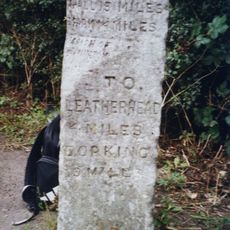
The trail partially follows Stane Street, an ancient Roman road that preserves connections to England's Roman past. These historic traces are particularly visible near Mickleham Downs.
The trail links two established long-distance paths and creates a connection between London's riverside character and Surrey's rolling hills. Walking here, you experience how the landscape transitions from urban waterways to rural uplands.
Navigation is straightforward with Ordnance Survey Explorer Map 146, and multiple railway stations provide convenient starting and ending points. Most walkers break the journey into sections rather than completing it in a single day.
The trail climbs from water level at Kingston Bridge to about 137 meters at Mickleham Downs while crossing two rivers: the Hogsmill River and River Mole. These river crossings become more challenging during wet seasons, adding variety to different visits.
The community of curious travelers
AroundUs brings together thousands of curated places, local tips, and hidden gems, enriched daily by 60,000 contributors worldwide.