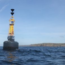
Wolf Rock Lighthouse, Lighthouse in Cornwall, United Kingdom.
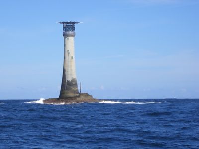
Wolf Rock Lighthouse is a granite and concrete tower standing 41 meters tall on a rocky outcrop off the Cornish coast near Land's End. The structure was built to guide ships safely through one of the most treacherous stretches of water along the English coast.
Engineers James Nicholas Douglass and James Walker designed the structure, which began operating in January 1870 after years of difficult construction work. Building on the exposed rock required innovative techniques and facing harsh ocean conditions.
The lighthouse stands as a symbol of safety for those crossing dangerous waters, representing how communities value protection of seafarers. Its presence along the coast reminds locals and visitors of the enduring relationship between land and maritime life.
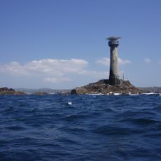
The lighthouse operates as a fully automated beacon monitored remotely, making it visible only from the water. The location is exposed and remote, so expect rough conditions and limit viewing to calmer days if approaching by boat.
This structure became the first lighthouse in the world to incorporate a helicopter landing platform when it was automated in 1988. This innovation allowed the remotely staffed light to receive quick maintenance and supply deliveries on the isolated rock.
Location: Cornwall
Inception: 1869
Architects: James Nicholas Douglass, James Walker
Height: 41 m
Made from material: granite, concrete
Website: https://trinityhouse.co.uk/lighthouses-and-lightvessels/wolf-rock-lighthouse
GPS coordinates: 49.94559,-5.80803
Latest update: December 7, 2025 19:31
Pedn Vounder
16.1 km
Longships Lighthouse
14.2 km
Museum of Global Communications
15.5 km
Runnel Stone
13.4 km
Maen Castle
15.9 km
St Levan's Church, St Levan
15.1 km
Porthgwarra to Pordenack Point
14 km
First And Last Inn
16.1 km
Porthcurno Beach
15.6 km
First And Last House
15.2 km
Roskestal Farmhouse, Including Front Garden Walls And Gate-Piers
14.6 km
Porthchapel Beach
15 km
Porthgwarra Beach
14.1 km
Porthgwarra Ullies
14.1 km
Cross 150m south west of Rospletha
15.3 km
Greeb Cottage
14.8 km
Milestone on the north side of the B3315 in the boundary wall entrance to Trevescan Farm Café
15.5 km
Cable Hut At Porthcurno Telegraph Station
15.7 km
Wayside cross in St Levan churchyard, 10m north east of the church
15.1 km
Holy well 30m north west of St Levan's Chapel
14.9 km
Barn And Adjoining Outbuilding At Aproximately 40 Metres North-North-East Of Roskestal Farmhouse
14.7 km
Carn Les Boel
14.2 km
Cross At Sw378223
15 km
Black/White Runnel Stone daymark
13.9 km
Minack Point
15.5 km
Churchyard cross in St Levan churchyard, 10m south of the church
15.1 km
World War Ii Tunnels At Porthcurno Telegraph Station
15.7 km
Milestone At Sw377233
15.9 kmVisited this place? Tap the stars to rate it and share your experience / photos with the community! Try now! You can cancel it anytime.
Discover hidden gems everywhere you go!
From secret cafés to breathtaking viewpoints, skip the crowded tourist spots and find places that match your style. Our app makes it easy with voice search, smart filtering, route optimization, and insider tips from travelers worldwide. Download now for the complete mobile experience.
A unique approach to discovering new places❞
— Le Figaro
All the places worth exploring❞
— France Info
A tailor-made excursion in just a few clicks❞
— 20 Minutes