Enable Location

We need your location to show you interesting places around you

Discover nearby places

Find interesting locations and hidden gems around you

Precise directions

Get accurate directions and distances to places

Your location is never shared with other users. It's only used when you tap the location button.

Elizabethton Covered Bridge

Log in to your account

Start exploring — it's free

Trusted by 63,010 travelers worldwide

Continue with Google
Continue with Apple
or

We will send you a code to connect

By continuing, you accept our Terms and Conditions and our Privacy Policy

Check your inbox

We've sent a pincode in your inbox. Please enter the code below.

Elizabethton Covered Bridge
Discussion Reviews 1 Photos
2.7k Popularity

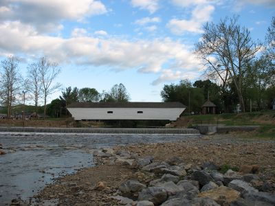
Elizabethton Covered Bridge, Covered bridge in Elizabethton, United States.

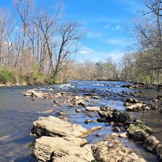
The Elizabethton Covered Bridge is a wooden structure spanning the Doe River with traditional Howe truss construction and internal walkways. It connects 3rd Street to Hattie Avenue and now accommodates pedestrian traffic only.

Built in 1882, this bridge was the only major structure to survive the devastating flood of 1901 in the Carter County area. Its resilience made it a landmark of survival during that natural disaster.

The bridge reflects the region's engineering heritage and serves as a gathering point where locals and visitors walk and pause to take in the river views. Community celebrations highlight its role in connecting people across the water.

Access is on foot, and the bridge sits conveniently between 3rd Street and Hattie Avenue for easy navigation. Nearby parking and adjacent park facilities make a visit straightforward and comfortable for families.

Doctor E. E. Hunter, who oversaw construction, humorously called it his 'five dollar bridge' because he made minimal profit from the project. This anecdote reveals the human side of an engineering achievement.

The community of curious travelers

AroundUs brings together thousands of curated places, local tips, and hidden gems, enriched daily by 60,000 contributors worldwide.

Start exploring
Location
Part of
Elizabethton Historic District
GPS coordinates
36.34730,-82.21180
Latest update
December 12, 2025 14:20
Around this place
Bristol Motor Speedway
United States of America

Bristol Motor Speedway

19.2 km
Watauga Lake
United States of America

Watauga Lake

18.8 km
United States of America

Gray Fossil Site

26 km
Sycamore Shoals
United States of America

Sycamore Shoals

4 km
Roan Mountain State Park
United States of America

Roan Mountain State Park

22.2 km
Overmountain Victory National Historic Trail
United States of America

Overmountain Victory National Historic Trail

184 m
South Holston Lake
United States of America

South Holston Lake

22.6 km
William B. Greene Jr. Stadium
United States of America

William B. Greene Jr. Stadium

15.5 km
Boone Lake
United States of America

Boone Lake

22.8 km
Sycamore Shoals State Historic Area
United States of America

Sycamore Shoals State Historic Area

3.6 km
Tipton-Haynes State Historic Site
United States of America

Tipton-Haynes State Historic Site

12.6 km
Rocky Mount, Tennessee
United States of America

Rocky Mount, Tennessee

13 km
Mountain Home National Cemetery
United States of America

Mountain Home National Cemetery

15.3 km
Bristol Municipal Stadium
United States of America

Bristol Municipal Stadium

26.3 km
Sabine Hill
United States of America

Sabine Hill

5.7 km
Jonesborough Historic District
United States of America

Jonesborough Historic District

24.2 km
Aquone
United States of America

Aquone

14.1 km
Sycamore Shoals State Historic Park
United States of America

Sycamore Shoals State Historic Park

3.9 km
Simerly-Butler House
United States of America

Simerly-Butler House

7.9 km
Shelbridge
United States of America

Shelbridge

13.9 km
John T. Wilder House
United States of America

John T. Wilder House

21.1 km
Bristol Commercial Historic District
United States of America

Bristol Commercial Historic District

27.6 km
Thankful Baptist Church
United States of America

Thankful Baptist Church

12.9 km
Jonesborough United Methodist Church
United States of America

Jonesborough United Methodist Church

24.4 km
Henry Hoss House
United States of America

Henry Hoss House

23.1 km
Bonnie Kate Theatre
United States of America

Bonnie Kate Theatre

282 m
Paramount Center for the Arts
United States of America

Paramount Center for the Arts

27.7 km
Elizabethton Historic District
United States of America

Elizabethton Historic District

65 m
Show the full map
Reviews
Share your experience

No review yet

Discussions
Start a discussion...

No discussion yet

« Elizabethton Covered Bridge - Covered bridge in Elizabethton, United States » is provided by Around Us (aroundus.com). Images and texts are derived from Wikimedia project under a Creative Commons license. You are allowed to copy, distribute, and modify copies of this page, under the conditions set by the license, as long as this note is clearly visible.

Discover hidden gems everywhere you go!

From secret cafés to breathtaking viewpoints, skip the crowded tourist spots and find places that match your style. Our app makes it easy with voice search, smart filtering, route optimization, and insider tips from travelers worldwide. Download now for the complete mobile experience.

Around Us App Screenshot

A unique approach to discovering new places

Le Figaro

All the places worth exploring

France Info

A tailor-made excursion in just a few clicks

20 Minutes

Around Us
Travel Guide & Maps
Download

Send to your phone

QR Code
1

Open the camera app on your mobile.

2

Point at the QR code with your camera. A notification will appear.

3

Tap the notification to open the link.