Enable Location

We need your location to show you interesting places around you

Discover nearby places

Find interesting locations and hidden gems around you

Precise directions

Get accurate directions and distances to places

Your location is never shared with other users. It's only used when you tap the location button.

South Holston Lake

Log in to your account

Start exploring — it's free

Trusted by 63,010 travelers worldwide

Continue with Google
Continue with Apple
or

We will send you a code to connect

By continuing, you accept our Terms and Conditions and our Privacy Policy

Check your inbox

We've sent a pincode in your inbox. Please enter the code below.

South Holston Lake
Discussion Reviews 1 Photos
8.6k Popularity

South Holston Lake, lake in Tennessee and Virginia, US

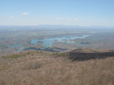
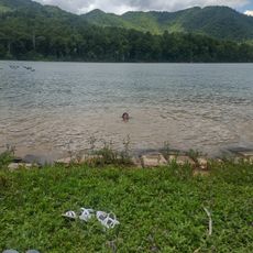
South Holston Lake is a reservoir in Tennessee created by damming the South Holston River, spanning several miles with tree-lined shores and gentle slopes surrounding the water. The lake provides water storage for electricity generation, flood management, and recreational activities throughout the year.

The lake was created in the 1940s by damming the river to generate power and protect the valley from flooding, becoming part of the Tennessee Valley Authority's broader development efforts. This infrastructure became crucial for regional energy supply and water management.

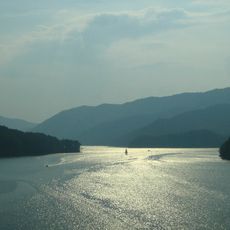
The lake is accessible year-round with multiple public access areas, beaches, and boat ramps scattered along its shoreline. Water levels fluctuate seasonally, so visitors should check current conditions before planning water activities or fishing trips.

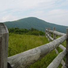
The lake is known for its healthy trout population, attracting anglers who visit year-round for fishing. Mountain trails run through the surrounding hills, offering visitors who prefer land-based activities an alternative way to explore the area.

The community of curious travelers

AroundUs brings together thousands of curated places, local tips, and hidden gems, enriched daily by 60,000 contributors worldwide.

Start exploring
Location
GPS coordinates
36.52417,-82.08750
Latest update
December 15, 2025 13:27
Around this place
Bristol Motor Speedway
United States of America

Bristol Motor Speedway

15.2 km
Watauga Lake
United States of America

Watauga Lake

22.6 km
Virginia Intermont College
United States of America

Virginia Intermont College

12 km
Barter Theatre
United States of America

Barter Theatre

23.4 km
Bristol Virginia-Tennessee Slogan Sign
United States of America

Bristol Virginia-Tennessee Slogan Sign

11.4 km
Overmountain Victory National Historic Trail
United States of America

Overmountain Victory National Historic Trail

22.4 km
United States of America

Birthplace of Country Music Museum

11.7 km
Sycamore Shoals State Historic Area
United States of America

Sycamore Shoals State Historic Area

24.8 km
Elizabethton Covered Bridge
United States of America

Elizabethton Covered Bridge

22.6 km
Bristol Municipal Stadium
United States of America

Bristol Municipal Stadium

10.7 km
Moonlite Drive-In
United States of America

Moonlite Drive-In

17 km
Heartwood – The Southwest Virginia Artisan Gateway
United States of America

Heartwood – The Southwest Virginia Artisan Gateway

20.6 km
East Hill Cemetery
United States of America

East Hill Cemetery

10.8 km
Mont Calm
United States of America

Mont Calm

22.7 km
Abingdon Bank
United States of America

Abingdon Bank

23.5 km
Solar Hill Historic District
United States of America

Solar Hill Historic District

12.1 km
Virginia Middle School
United States of America

Virginia Middle School

12.4 km
Walnut Grove
United States of America

Walnut Grove

13.1 km
Euclid Avenue Historic District (Bristol, Virginia)
United States of America

Euclid Avenue Historic District (Bristol, Virginia)

12.5 km
Bristol Commercial Historic District
United States of America

Bristol Commercial Historic District

11.6 km
Douglass School
United States of America

Douglass School

12.3 km
Dr. William H. Pitts House
United States of America

Dr. William H. Pitts House

23.5 km
Virginia Hill Historic District
United States of America

Virginia Hill Historic District

12.6 km
King-Lancaster-McCoy-Mitchell House
United States of America

King-Lancaster-McCoy-Mitchell House

12.1 km
Shook Branch Swimming Area
United States of America

Shook Branch Swimming Area

24.9 km
Kettlefoot Fire Lookout Tower
United States of America

Kettlefoot Fire Lookout Tower

22.5 km
Bonnie Kate Theatre
United States of America

Bonnie Kate Theatre

22.7 km
Paramount Center for the Arts
United States of America

Paramount Center for the Arts

11.5 km
Show the full map
Reviews
Share your experience

No review yet

Discussions
Start a discussion...

No discussion yet

« South Holston Lake - lake in Tennessee and Virginia, US » is provided by Around Us (aroundus.com). Images and texts are derived from Wikimedia project under a Creative Commons license. You are allowed to copy, distribute, and modify copies of this page, under the conditions set by the license, as long as this note is clearly visible.

Discover hidden gems everywhere you go!

From secret cafés to breathtaking viewpoints, skip the crowded tourist spots and find places that match your style. Our app makes it easy with voice search, smart filtering, route optimization, and insider tips from travelers worldwide. Download now for the complete mobile experience.

Around Us App Screenshot

A unique approach to discovering new places

Le Figaro

All the places worth exploring

France Info

A tailor-made excursion in just a few clicks

20 Minutes

Around Us
Travel Guide & Maps
Download

Send to your phone

QR Code
1

Open the camera app on your mobile.

2

Point at the QR code with your camera. A notification will appear.

3

Tap the notification to open the link.