Estivant Pines

Log in to your account

AroundUs is a community-driven map of interesting places, built by curious explorers like you. It grows with every review, story, and photo you share.
Connect to save your favorite spots, contribute locations, and create personalized routes.
By continuing, you accept our Terms and Conditions and our Privacy Policy
Add to collection
Map
Suggest a change
Share

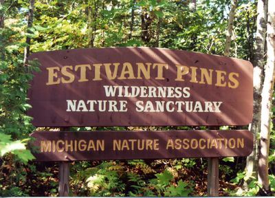
Estivant Pines, Nature reserve in Keweenaw County, Michigan, United States.

Estivant Pines is a nature reserve in Michigan covering about 570 acres of old-growth forest dominated by white pine trees rising over 120 feet (37 m) into the canopy. Two marked trails wind through the sanctuary: the Cathedral Grove loop and another path that explores the deeper forest.

The Michigan Nature Association purchased the first 200 acres from an oil company in 1973 after local residents fought against logging plans. The acquisition saved this forest from industrial cutting.

One of the trails is named after Bertha Daubendiek, the founder of the association that fought to protect this forest from logging. The path connects visitors to the history of those who saved the place.

You can reach the reserve via Burma Road during the warmer months, but winter visits need snowshoes or skis because snow covers the trails. The best time to walk the paths is late spring through early fall.

Some of the pine trees here began growing around 1695 and rank among the oldest living organisms on the Peninsula. These ancient trees have survived centuries of change and remain silent witnesses to the forest's story.

Location: Michigan

Location: Grant Township

Location: Keweenaw County

Operator: Michigan Nature Association

Phone: +18662232231

Website: https://michigannature.iescentral.com/index.cfm?fuseaction=locationgallery&action=listing&listing=110

GPS coordinates: 47.44600,-87.87750

Latest update: December 12, 2025 07:52

Photos
Around this place
Fort Wilkins Historic State Park
United States of America

Fort Wilkins Historic State Park

2.4 km
SS S.R. Kirby
United States of America

SS S.R. Kirby

28.9 km
Copper Harbor Light
United States of America

Copper Harbor Light

3.4 km
SS Hudson
United States of America

SS Hudson

28.9 km
Eagle Harbor Light
United States of America

Eagle Harbor Light

21.3 km
Gull Rock Light Station
United States of America

Gull Rock Light Station

16.4 km
Keweenaw Mountain Lodge and Golf Course Complex
United States of America

Keweenaw Mountain Lodge and Golf Course Complex

2.6 km
Manitou Island Light Station
United States of America

Manitou Island Light Station

22.1 km
Mendota Light
United States of America

Mendota Light

10.4 km
Central Mine Historic District
United States of America

Central Mine Historic District

24.7 km
Church of the Assumption
United States of America

Church of the Assumption

30.7 km
Eagle Harbor Schoolhouse
United States of America

Eagle Harbor Schoolhouse

21.5 km
Eagle Harbor Coast Guard Station Boathouse
United States of America

Eagle Harbor Coast Guard Station Boathouse

20.5 km
US 41–Fanny Hooe Creek Bridge
United States of America

US 41–Fanny Hooe Creek Bridge

2.4 km
Central Mine Methodist Church
United States of America

Central Mine Methodist Church

25 km
Holy Redeemer Church
United States of America

Holy Redeemer Church

21.7 km
M-26–Silver River Culvert
United States of America

M-26–Silver River Culvert

14.8 km
M-26–Cedar Creek Culvert
United States of America

M-26–Cedar Creek Culvert

20.5 km
Klipfel
United States of America

Klipfel

6.4 km
Eagle River Historic District
United States of America

Eagle River Historic District

31.8 km
Great Sand Bay Conservation and Recreation Area
United States of America

Great Sand Bay Conservation and Recreation Area

25.6 km
Bete Grise North Public Beach
United States of America

Bete Grise North Public Beach

9.3 km
Horseshoe Harbor Beach
United States of America

Horseshoe Harbor Beach

6.4 km
Keweenaw County Courthouse
United States of America

Keweenaw County Courthouse

31.6 km
Houghton Township Community Center
United States of America

Houghton Township Community Center

31.7 km
Eagle Harbor House Historical Marker
United States of America

Eagle Harbor House Historical Marker

21.4 km
Hunter's Point Park
United States of America

Hunter's Point Park

3.4 km
Eagle River Beach
United States of America

Eagle River Beach

31.8 km
Show the full map
Reviews

Visited this place? Tap the stars to rate it and share your experience / photos with the community! Try now! You can cancel it anytime.

« Estivant Pines - Nature reserve in Keweenaw County, Michigan, United States » is provided by Around Us (aroundus.com). Images and texts are derived from Wikimedia project under a Creative Commons license. You are allowed to copy, distribute, and modify copies of this page, under the conditions set by the license, as long as this note is clearly visible.

Discover hidden gems everywhere you go!

From secret cafés to breathtaking viewpoints, skip the crowded tourist spots and find places that match your style. Our app makes it easy with voice search, smart filtering, route optimization, and insider tips from travelers worldwide. Download now for the complete mobile experience.

Around Us App Screenshot

A unique approach to discovering new places

Le Figaro

All the places worth exploring

France Info

A tailor-made excursion in just a few clicks

20 Minutes