Frankenfield Covered Bridge

Log in to your account

AroundUs is a community-driven map of interesting places, built by curious explorers like you. It grows with every review, story, and photo you share.
Connect to save your favorite spots, contribute locations, and create personalized routes.
Continue with Google
Continue with Apple
Continue with X
Continue with Facebook
Continue with email
By continuing, you accept our Terms and Conditions and our Privacy Policy
Create an account
Add to collection
Map
Suggest a change
Share

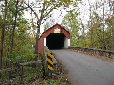
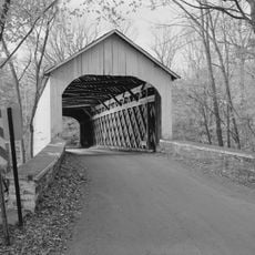
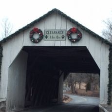
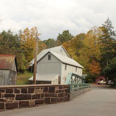
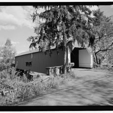
Frankenfield Covered Bridge, Wooden covered bridge in Point Pleasant, Pennsylvania, US

Frankenfield Covered Bridge spans 82 feet across Tinicum Creek using a town truss design with sturdy oak construction and protective wooden walls. The structure sits on Cafferty Road with a 9.42-foot clearance for vehicles passing through.

Built in 1872, this structure was added to the National Register of Historic Places in 1980 for its engineering and architectural significance. The recognition acknowledged its importance as a 19th-century transportation solution in rural Pennsylvania.

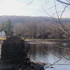
This bridge is part of Pennsylvania's collection of covered structures that demonstrate how 19th-century communities solved the challenge of crossing water. Walking across allows visitors to see firsthand the craftsmanship and wooden construction methods that local builders used.

Access is via Cafferty Road and the bridge remains open for vehicle traffic, though crossing at appropriate speed is recommended. The low 9.42-foot clearance means larger vehicles should proceed carefully or use alternative routes.

The structure uses the town truss system where diagonally arranged wooden beams distribute weight in a specific way that was innovative for its era. This engineering approach allowed builders to span longer distances than previous methods could achieve.
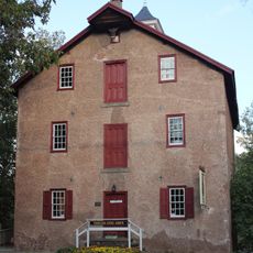
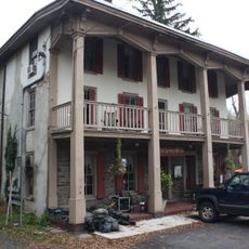
Location: Pennsylvania

GPS coordinates: 40.47580,-75.09940

Latest update: December 14, 2025 18:15

Photos
Around this place
Treasure Island Scout Reservation
United States of America

Treasure Island Scout Reservation

2.9 km
Ralph Stover State Park
United States of America

Ralph Stover State Park

4.6 km
Delaware Canal State Park
United States of America

Delaware Canal State Park

8.4 km
Lumberville – Raven Rock Bridge
United States of America

Lumberville – Raven Rock Bridge

9.2 km
Bulls Island Recreation Area
United States of America

Bulls Island Recreation Area

9.1 km
Uhlerstown–Frenchtown Bridge
United States of America

Uhlerstown–Frenchtown Bridge

6.3 km
Ringing Rocks County Park
United States of America

Ringing Rocks County Park

9.8 km
Lower Delaware National Wild and Scenic River
United States of America

Lower Delaware National Wild and Scenic River

4.2 km
Upper Black Eddy – Milford Bridge
United States of America

Upper Black Eddy – Milford Bridge

10.1 km
Point Pleasant-Byram Bridge
United States of America

Point Pleasant-Byram Bridge

6.7 km
Loux Covered Bridge
United States of America

Loux Covered Bridge

6.3 km
Stover-Myers Mill
United States of America

Stover-Myers Mill

4.7 km
Bridge in Tinicum Township
United States of America

Bridge in Tinicum Township

6.5 km
Isaac Stover House
United States of America

Isaac Stover House

3.5 km
Stover Mill
United States of America

Stover Mill

3.5 km
Carversville Historic District
United States of America

Carversville Historic District

10.6 km
Erwinna Covered Bridge
United States of America

Erwinna Covered Bridge

3.6 km
Thatcher House
United States of America

Thatcher House

9.4 km
Bridge in Solebury Township
United States of America

Bridge in Solebury Township

10.5 km
Raven Rock Historic District
United States of America

Raven Rock Historic District

9.1 km
Point Pleasant Historic District
United States of America

Point Pleasant Historic District

6.6 km
Lewis Summers Farm
United States of America

Lewis Summers Farm

4.4 km
Lumberville Historic District
United States of America

Lumberville Historic District

9.6 km
Ridge Valley Rural Historic District
United States of America

Ridge Valley Rural Historic District

3.6 km
Locktown Baptist Church
United States of America

Locktown Baptist Church

10.8 km
Ringing Rocks County Park
United States of America

Ringing Rocks County Park

9.8 km
Frenchtown Historic District
United States of America

Frenchtown Historic District

6.5 km
Uhlerstown Covered Bridge
United States of America

Uhlerstown Covered Bridge

6 km
Show the full map
Reviews

Visited this place? Tap the stars to rate it and share your experience / photos with the community! Try now! You can cancel it anytime.

« Frankenfield Covered Bridge - Wooden covered bridge in Point Pleasant, Pennsylvania, US » is provided by Around Us (aroundus.com). Images and texts are derived from Wikimedia project under a Creative Commons license. You are allowed to copy, distribute, and modify copies of this page, under the conditions set by the license, as long as this note is clearly visible.

Discover hidden gems everywhere you go!

From secret cafés to breathtaking viewpoints, skip the crowded tourist spots and find places that match your style. Our app makes it easy with voice search, smart filtering, route optimization, and insider tips from travelers worldwide. Download now for the complete mobile experience.

Around Us App Screenshot

A unique approach to discovering new places

Le Figaro

All the places worth exploring

France Info

A tailor-made excursion in just a few clicks

20 Minutes