Point Pleasant-Byram Bridge

Log in to your account

AroundUs is a community-driven map of interesting places, built by curious explorers like you. It grows with every review, story, and photo you share.
Connect to save your favorite spots, contribute locations, and create personalized routes.
Continue with Google
Continue with Apple
Continue with X
Continue with Facebook
Continue with email
By continuing, you accept our Terms and Conditions and our Privacy Policy
Create an account

Point Pleasant-Byram Bridge

Add to collection
Map
Suggest a change
Share

Point Pleasant-Byram Bridge, Steel river bridge in Point Pleasant, US

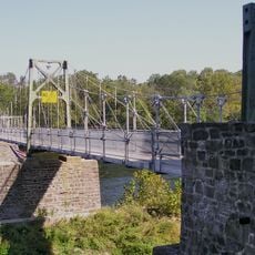
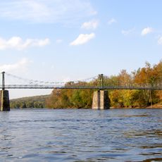
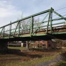
The Point Pleasant-Byram Bridge was a steel structure spanning the Delaware River between Pennsylvania and New Jersey with four main sections. The crossing connected both banks with a robust framework designed to carry traffic between the two states.

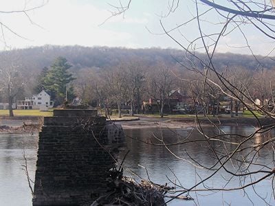
The bridge began as a wooden covered structure in 1855 but faced repeated damage from floods and fires throughout its existence. By 1955 it was destroyed and never rebuilt, leaving only stone piers as evidence of its former presence.

The bridge served as a gathering point where residents from both sides came together for business and social life. This crossing shaped how neighboring communities on opposite banks interacted with each other over time.

Stone piers remaining in the Delaware River mark where the bridge once stood between Point Pleasant, Pennsylvania and Byram, New Jersey. The site can be viewed from both riverbanks, giving visitors a chance to see the remnants of this former crossing.

The structure operated as a toll bridge for decades before public authorities took over in 1919, shifting it from private to public operation. This change marked a significant shift in how the crossing was managed and maintained over time.

GPS coordinates: 40.42300,-75.06100

Latest update: December 14, 2025 14:42

Photos
Around this place
Treasure Island Scout Reservation
United States of America

Treasure Island Scout Reservation

5.5 km
Ralph Stover State Park
United States of America

Ralph Stover State Park

3.4 km
Lumberville – Raven Rock Bridge
United States of America

Lumberville – Raven Rock Bridge

2.6 km
Bulls Island Recreation Area
United States of America

Bulls Island Recreation Area

2.6 km
Green Sergeant's Covered Bridge
United States of America

Green Sergeant's Covered Bridge

8.4 km
Buckingham Friends Meeting House
United States of America

Buckingham Friends Meeting House

8.4 km
Centre Bridge–Stockton Bridge
United States of America

Centre Bridge–Stockton Bridge

7.3 km
Lower Delaware National Wild and Scenic River
United States of America

Lower Delaware National Wild and Scenic River

8.9 km
Loux Covered Bridge
United States of America

Loux Covered Bridge

5.7 km
Longland
United States of America

Longland

8.8 km
Frankenfield Covered Bridge
United States of America

Frankenfield Covered Bridge

6.7 km
Stover-Myers Mill
United States of America

Stover-Myers Mill

5.6 km
Bridge in Tinicum Township
United States of America

Bridge in Tinicum Township

362 m
Isaac Stover House
United States of America

Isaac Stover House

8.3 km
Stover Mill
United States of America

Stover Mill

8.2 km
Covered Bridge Historic District
United States of America

Covered Bridge Historic District

8.6 km
Carversville Historic District
United States of America

Carversville Historic District

4.1 km
Cuttalossa Valley Historic District
United States of America

Cuttalossa Valley Historic District

4.5 km
Center Bridge Historic District
United States of America

Center Bridge Historic District

7.3 km
Bridge in Solebury Township
United States of America

Bridge in Solebury Township

4.1 km
Raven Rock Historic District
United States of America

Raven Rock Historic District

2.7 km
Point Pleasant Historic District
United States of America

Point Pleasant Historic District

441 m
Lumberville Historic District
United States of America

Lumberville Historic District

2.9 km
Mechanicsville Village Historic District
United States of America

Mechanicsville Village Historic District

8.9 km
District No. 98 Schoolhouse
United States of America

District No. 98 Schoolhouse

7.5 km
Upper Aquetong Valley Historic District
United States of America

Upper Aquetong Valley Historic District

8.4 km
Gardenville-North Branch Rural Historic District
United States of America

Gardenville-North Branch Rural Historic District

7 km
Isaiah Paxson Farm
United States of America

Isaiah Paxson Farm

6.4 km
Show the full map
Reviews

Visited this place? Tap the stars to rate it and share your experience / photos with the community! Try now! You can cancel it anytime.

« Point Pleasant-Byram Bridge - Steel river bridge in Point Pleasant, US » is provided by Around Us (aroundus.com). Images and texts are derived from Wikimedia project under a Creative Commons license. You are allowed to copy, distribute, and modify copies of this page, under the conditions set by the license, as long as this note is clearly visible.

Discover hidden gems everywhere you go!

From secret cafés to breathtaking viewpoints, skip the crowded tourist spots and find places that match your style. Our app makes it easy with voice search, smart filtering, route optimization, and insider tips from travelers worldwide. Download now for the complete mobile experience.

Around Us App Screenshot

A unique approach to discovering new places

Le Figaro

All the places worth exploring

France Info

A tailor-made excursion in just a few clicks

20 Minutes