Enable Location

We need your location to show you interesting places around you

Discover nearby places

Find interesting locations and hidden gems around you

Precise directions

Get accurate directions and distances to places

Your location is never shared with other users. It's only used when you tap the location button.

Centre Bridge–Stockton Bridge

Log in to your account

Start exploring — it's free

Trusted by 61,556 travelers worldwide

Continue with Google
Continue with Apple
or

We will send you a code to connect

By continuing, you accept our Terms and Conditions and our Privacy Policy

Check your inbox

We've sent a pincode in your inbox. Please enter the code below.

Centre Bridge–Stockton Bridge

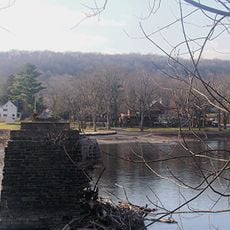
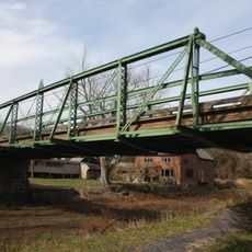
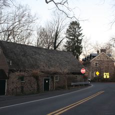
Centre Bridge–Stockton Bridge, Steel truss road bridge between Stockton, New Jersey and Solebury Township, Pennsylvania

Description

Centre Bridge-Stockton Bridge is a steel truss structure that spans the Delaware River between Stockton, New Jersey and Solebury Township, Pennsylvania. The roadway is wide enough for two-way traffic and rests on massive stone foundation piers that rise from the riverbed.

History

A wooden covered bridge originally crossed the Delaware River at this location until lightning struck and destroyed it in 1923. The toll bridge commission rebuilt the crossing in 1927 with steel construction as a permanent solution.

Culture

Edward Willis Redfield created a painting depicting the 1923 fire that consumed the previous wooden bridge at this crossing point.

Practical

The bridge connects Pennsylvania Route 263 to New Jersey Route 29 and handles regular traffic flow in both directions. Walkers and cyclists should be aware that this is an active road bridge with vehicle traffic to navigate.

Did you know?

The stone piers supporting this bridge were first built in 1813 for an earlier river crossing and were enclosed in concrete during the 1926 rebuild. Few visitors realize they are walking on foundations that have served this location for over 200 years.

Location
Location
Inception
1927
Official opening
1927
GPS coordinates
40.40306,-74.97944
Latest update
December 14, 2025 12:21

AroundUs brings together thousands of curated places, local tips, and hidden gems, enriched daily by 60,000 contributors worldwide. Discover all places nearby (New Jersey).

Around this place
Bucks County Playhouse
United States of America

Bucks County Playhouse

5.2 km
New Hope – Lambertville Bridge
United States of America

New Hope – Lambertville Bridge

5 km
George Nakashima House, Studio and Workshop
United States of America

George Nakashima House, Studio and Workshop

7.3 km
Lumberville – Raven Rock Bridge
United States of America

Lumberville – Raven Rock Bridge

4.9 km
Bulls Island Recreation Area
United States of America

Bulls Island Recreation Area

4.8 km
Green Sergeant's Covered Bridge
United States of America

Green Sergeant's Covered Bridge

4.7 km
Cintra
United States of America

Cintra

4.7 km
Lambertville House
United States of America

Lambertville House

5 km
Point Pleasant-Byram Bridge
United States of America

Point Pleasant-Byram Bridge

7.3 km
James W. Marshall House
United States of America

James W. Marshall House

5.1 km
Bridge in Tinicum Township
United States of America

Bridge in Tinicum Township

7.6 km
Lambertville Historic District
United States of America

Lambertville Historic District

5.2 km
Covered Bridge Historic District
United States of America

Covered Bridge Historic District

4.9 km
Carversville Historic District
United States of America

Carversville Historic District

7.1 km
Phillips Mill Historic District
United States of America

Phillips Mill Historic District

2.4 km
Cuttalossa Valley Historic District
United States of America

Cuttalossa Valley Historic District

3.9 km
Center Bridge Historic District
United States of America

Center Bridge Historic District

277 m
Joshua Ely House
United States of America

Joshua Ely House

5.4 km
Bridge in Solebury Township
United States of America

Bridge in Solebury Township

7.4 km
Springdale Historic District
United States of America

Springdale Historic District

4.8 km
Rhoads Homestead
United States of America

Rhoads Homestead

4.6 km
Raven Rock Historic District
United States of America

Raven Rock Historic District

4.7 km
Lumberville Historic District
United States of America

Lumberville Historic District

4.9 km
District No. 98 Schoolhouse
United States of America

District No. 98 Schoolhouse

574 m
Upper Aquetong Valley Historic District
United States of America

Upper Aquetong Valley Historic District

4.9 km
New Hope – Lambertville Toll Bridge
United States of America

New Hope – Lambertville Toll Bridge

3.3 km
Isaiah Paxson Farm
United States of America

Isaiah Paxson Farm

849 m
New Hope Village District
United States of America

New Hope Village District

5.5 km
Show the full map
« Centre Bridge–Stockton Bridge - Steel truss road bridge between Stockton, New Jersey and Solebury Township, Pennsylvania » is provided by Around Us (aroundus.com). Images and texts are derived from Wikimedia project under a Creative Commons license. You are allowed to copy, distribute, and modify copies of this page, under the conditions set by the license, as long as this note is clearly visible.

Discover hidden gems everywhere you go!

From secret cafés to breathtaking viewpoints, skip the crowded tourist spots and find places that match your style. Our app makes it easy with voice search, smart filtering, route optimization, and insider tips from travelers worldwide. Download now for the complete mobile experience.

Around Us App Screenshot

A unique approach to discovering new places

Le Figaro

All the places worth exploring

France Info

A tailor-made excursion in just a few clicks

20 Minutes

Around Us
Travel Guide & Maps
Download

Send to your phone

QR Code
1

Open the camera app on your mobile.

2

Point at the QR code with your camera. A notification will appear.

3

Tap the notification to open the link.