Enable Location

We need your location to show you interesting places around you

Discover nearby places

Find interesting locations and hidden gems around you

Precise directions

Get accurate directions and distances to places

Your location is never shared with other users. It's only used when you tap the location button.

Cintra

Log in to your account

Start exploring — it's free

Trusted by 62,358 travelers worldwide

Continue with Google
Continue with Apple
or

We will send you a code to connect

By continuing, you accept our Terms and Conditions and our Privacy Policy

Check your inbox

We've sent a pincode in your inbox. Please enter the code below.

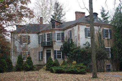
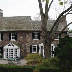
Cintra, Historic mansion in New Hope, Pennsylvania, United States.

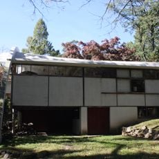
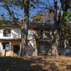
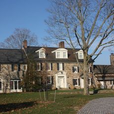
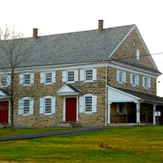
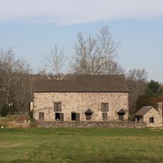
Cintra was a stone mansion with an L-shaped layout built in 1824 on 4.6 acres of land. The structure featured a hipped roof, a central core area, and two matching wings that created a balanced composition.

William Maris built the structure in 1824 and drew inspiration from Portuguese palace architecture in its design. The mansion stood on Bridge Street until its demolition in 2023.

The mansion was a landmark in local architecture and shaped how New Hope looked through its distinctive design. People in the area noticed how the building influenced the character of the neighborhood and attracted attention from those interested in historical construction.

The property was located at 181 West Bridge Street in New Hope and was easy to find using this address. Since the building was demolished in 2023 following an engineering assessment, visitors today can only view the empty site and learn about its history through local records.

The mansion drew inspiration from Portuguese palace architecture, which set it apart from other buildings of its time. This unusual design choice became its defining feature and made it particularly valuable to those interested in architectural history.

The community of curious travelers

AroundUs brings together thousands of curated places, local tips, and hidden gems, enriched daily by 60,000 contributors worldwide.

Start exploring
Location
GPS coordinates
40.36410,-74.95930
Latest update
December 14, 2025 12:20
Around this place
Bucks County Playhouse
United States of America

Bucks County Playhouse

797 m
Bowman's Hill Tower
United States of America

Bowman's Hill Tower

4.6 km
New Hope – Lambertville Bridge
United States of America

New Hope – Lambertville Bridge

913 m
George Nakashima House, Studio and Workshop
United States of America

George Nakashima House, Studio and Workshop

2.7 km
Bowman's Hill Wildflower Preserve
United States of America

Bowman's Hill Wildflower Preserve

4.1 km
Howell Living History Farm
United States of America

Howell Living History Farm

5.4 km
London Purchase Farm
United States of America

London Purchase Farm

5.8 km
Van Sant Covered Bridge
United States of America

Van Sant Covered Bridge

4.1 km
Buckingham Friends Meeting House
United States of America

Buckingham Friends Meeting House

7.1 km
Thompson-Neely House
United States of America

Thompson-Neely House

4 km
Centre Bridge–Stockton Bridge
United States of America

Centre Bridge–Stockton Bridge

4.7 km
Lambertville House
United States of America

Lambertville House

1.2 km
James W. Marshall House
United States of America

James W. Marshall House

1.3 km
Lambertville Historic District
United States of America

Lambertville Historic District

1.4 km
Phillips Mill Historic District
United States of America

Phillips Mill Historic District

2.3 km
Brownsburg Village Historic District
United States of America

Brownsburg Village Historic District

6 km
Cuttalossa Valley Historic District
United States of America

Cuttalossa Valley Historic District

6.4 km
Center Bridge Historic District
United States of America

Center Bridge Historic District

4.4 km
Joshua Ely House
United States of America

Joshua Ely House

773 m
Atkinson Road Bridge
United States of America

Atkinson Road Bridge

4.4 km
Springdale Historic District
United States of America

Springdale Historic District

461 m
Rhoads Homestead
United States of America

Rhoads Homestead

317 m
Smith Family Farmstead
United States of America

Smith Family Farmstead

5.8 km
Buckmanville Historic District
United States of America

Buckmanville Historic District

5.7 km
District No. 98 Schoolhouse
United States of America

District No. 98 Schoolhouse

5 km
Upper Aquetong Valley Historic District
United States of America

Upper Aquetong Valley Historic District

3.6 km
New Hope – Lambertville Toll Bridge
United States of America

New Hope – Lambertville Toll Bridge

1.7 km
Isaiah Paxson Farm
United States of America

Isaiah Paxson Farm

5.1 km
Show the full map
« Cintra - Historic mansion in New Hope, Pennsylvania, United States » is provided by Around Us (aroundus.com). Images and texts are derived from Wikimedia project under a Creative Commons license. You are allowed to copy, distribute, and modify copies of this page, under the conditions set by the license, as long as this note is clearly visible.

Discover hidden gems everywhere you go!

From secret cafés to breathtaking viewpoints, skip the crowded tourist spots and find places that match your style. Our app makes it easy with voice search, smart filtering, route optimization, and insider tips from travelers worldwide. Download now for the complete mobile experience.

Around Us App Screenshot

A unique approach to discovering new places

Le Figaro

All the places worth exploring

France Info

A tailor-made excursion in just a few clicks

20 Minutes

Around Us
Travel Guide & Maps
Download

Send to your phone

QR Code
1

Open the camera app on your mobile.

2

Point at the QR code with your camera. A notification will appear.

3

Tap the notification to open the link.