Van Sant Covered Bridge
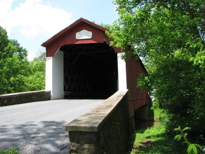
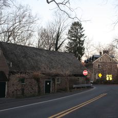
Van Sant Covered Bridge, Covered bridge in Solebury Township, Pennsylvania.
Van Sant Covered Bridge is a timber-roofed structure that crosses Pidcock Creek in a rural setting with red-painted wooden walls and white portal entries. The bridge carries traffic between two road names that change on either side of the crossing.
The bridge was completed in 1875 using a traditional timber truss design that was common during that era of construction. Its recognition on the National Register came in 1980, acknowledging its role as part of the region's transportation history.
The location holds local folklore significance with a long-standing story about unexplained sounds that residents have discussed for years. This tale has become part of the bridge's identity within the surrounding community.
The approach is via Route 32 toward Aquetong Road, then turning left to follow Covered Bridge Road for the final stretch. The roads in this area are narrow and winding, so take your time navigating to the crossing.
One distinctive feature is that the roadway changes its name on opposite sides of the structure. Drivers crossing it pass from Covered Bridge Road to Van Sant Road.
Location: Pennsylvania
GPS coordinates: 40.32694,-74.95806
Latest update: December 14, 2025 11:22
Bucks County Playhouse
4 km
Bowman's Hill Tower
1.7 km
Keith House
3.6 km
New Hope – Lambertville Bridge
4.3 km
George Nakashima House, Studio and Workshop
1.5 km
Bowman's Hill Wildflower Preserve
1.5 km
John and Alice Fullam House
5 km
Howell Living History Farm
4.9 km
London Purchase Farm
1.7 km
Waldenmark
6 km
Thompson-Neely House
1.8 km
Cintra
4.1 km
Lambertville House
4.5 km
James W. Marshall House
4.5 km
Lambertville Historic District
4.5 km
Hayhurst Farm
4.3 km
John Burroughs Homestead
6.8 km
Phillips Mill Historic District
6.3 km
Brownsburg Village Historic District
3.3 km
Joshua Ely House
3.4 km
Atkinson Road Bridge
1.8 km
Springdale Historic District
3.9 km
Rhoads Homestead
4.3 km
Smith Family Farmstead
2.8 km
Buckmanville Historic District
2.1 km
Upper Aquetong Valley Historic District
5.4 km
New Hope – Lambertville Toll Bridge
5.8 km
New Hope Village District
3.5 kmVisited this place? Tap the stars to rate it and share your experience / photos with the community! Try now! You can cancel it anytime.
Discover hidden gems everywhere you go!
From secret cafés to breathtaking viewpoints, skip the crowded tourist spots and find places that match your style. Our app makes it easy with voice search, smart filtering, route optimization, and insider tips from travelers worldwide. Download now for the complete mobile experience.
A unique approach to discovering new places❞
— Le Figaro
All the places worth exploring❞
— France Info
A tailor-made excursion in just a few clicks❞
— 20 Minutes