Enable Location

We need your location to show you interesting places around you

Discover nearby places

Find interesting locations and hidden gems around you

Precise directions

Get accurate directions and distances to places

Your location is never shared with other users. It's only used when you tap the location button.

New Hope – Lambertville Bridge

Log in to your account

Start exploring — it's free

Trusted by 62,351 travelers worldwide

Continue with Google
Continue with Apple
or

We will send you a code to connect

By continuing, you accept our Terms and Conditions and our Privacy Policy

Check your inbox

We've sent a pincode in your inbox. Please enter the code below.

New Hope – Lambertville Bridge

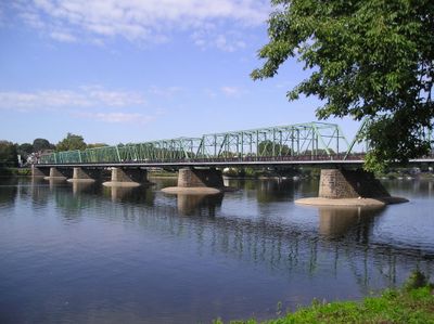
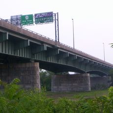
New Hope – Lambertville Bridge, Steel truss bridge between New Hope, Pennsylvania and Lambertville, New Jersey.

The New Hope-Lambertville Bridge is a 1,053-foot steel structure spanning the Delaware River between Pennsylvania and New Jersey. It features six connected Pratt trusses about 27 feet tall and carries Route 179 traffic along with a sewer line beneath its deck.

This crossing was built in 1904 to replace a wooden bridge lost to flooding. Thirteen years later, the two states purchased it and eliminated tolls for travelers.

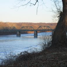
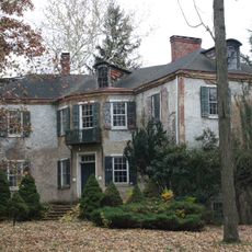
The bridge links two riverside towns where people walk across using a dedicated path on the southern side. Daily movement between the communities shapes how residents and visitors experience these connected places.

The bridge welcomes both vehicles and pedestrians daily, with a dedicated walkway on the southern side. Expect busy traffic during peak hours, though the crossing remains open and accessible to travelers at all times.

During the severe Delaware River flood of 1955, this structure stood firm while other crossings in the region failed. It returned to service in just five weeks, proving its strength against extreme conditions.

The community of curious travelers

AroundUs brings together thousands of curated places, local tips, and hidden gems, enriched daily by 60,000 contributors worldwide.

Start exploring
Location
Location
Official opening
1904
Part of
Route 179
GPS coordinates
40.36500,-74.94860
Latest update
December 10, 2025 16:30
Around this place
Bucks County Playhouse
United States of America

Bucks County Playhouse

330 m
Bowman's Hill Tower
United States of America

Bowman's Hill Tower

4.4 km
George Nakashima House, Studio and Workshop
United States of America

George Nakashima House, Studio and Workshop

2.8 km
Bowman's Hill Wildflower Preserve
United States of America

Bowman's Hill Wildflower Preserve

3.9 km
Howell Living History Farm
United States of America

Howell Living History Farm

4.7 km
London Purchase Farm
United States of America

London Purchase Farm

5.8 km
Van Sant Covered Bridge
United States of America

Van Sant Covered Bridge

4.3 km
Thompson-Neely House
United States of America

Thompson-Neely House

3.8 km
Centre Bridge–Stockton Bridge
United States of America

Centre Bridge–Stockton Bridge

5 km
Cintra
United States of America

Cintra

913 m
Lambertville House
United States of America

Lambertville House

270 m
James W. Marshall House
United States of America

James W. Marshall House

393 m
Lambertville Historic District
United States of America

Lambertville Historic District

509 m
Phillips Mill Historic District
United States of America

Phillips Mill Historic District

2.7 km
Brownsburg Village Historic District
United States of America

Brownsburg Village Historic District

5.6 km
Cuttalossa Valley Historic District
United States of America

Cuttalossa Valley Historic District

7.2 km
Center Bridge Historic District
United States of America

Center Bridge Historic District

4.8 km
Joshua Ely House
United States of America

Joshua Ely House

1.2 km
Atkinson Road Bridge
United States of America

Atkinson Road Bridge

4.9 km
Springdale Historic District
United States of America

Springdale Historic District

1.3 km
Rhoads Homestead
United States of America

Rhoads Homestead

669 m
Smith Family Farmstead
United States of America

Smith Family Farmstead

5.5 km
Buckmanville Historic District
United States of America

Buckmanville Historic District

6.1 km
District No. 98 Schoolhouse
United States of America

District No. 98 Schoolhouse

5.2 km
Upper Aquetong Valley Historic District
United States of America

Upper Aquetong Valley Historic District

4.5 km
New Hope – Lambertville Toll Bridge
United States of America

New Hope – Lambertville Toll Bridge

1.7 km
Isaiah Paxson Farm
United States of America

Isaiah Paxson Farm

5.5 km
New Hope Village District
United States of America

New Hope Village District

816 m
Show the full map
« New Hope – Lambertville Bridge - Steel truss bridge between New Hope, Pennsylvania and Lambertville, New Jersey » is provided by Around Us (aroundus.com). Images and texts are derived from Wikimedia project under a Creative Commons license. You are allowed to copy, distribute, and modify copies of this page, under the conditions set by the license, as long as this note is clearly visible.

Discover hidden gems everywhere you go!

From secret cafés to breathtaking viewpoints, skip the crowded tourist spots and find places that match your style. Our app makes it easy with voice search, smart filtering, route optimization, and insider tips from travelers worldwide. Download now for the complete mobile experience.

Around Us App Screenshot

A unique approach to discovering new places

Le Figaro

All the places worth exploring

France Info

A tailor-made excursion in just a few clicks

20 Minutes

Around Us
Travel Guide & Maps
Download

Send to your phone

QR Code
1

Open the camera app on your mobile.

2

Point at the QR code with your camera. A notification will appear.

3

Tap the notification to open the link.