Enable Location

We need your location to show you interesting places around you

Discover nearby places

Find interesting locations and hidden gems around you

Precise directions

Get accurate directions and distances to places

Your location is never shared with other users. It's only used when you tap the location button.

Fort Pitt Incline

Log in to your account

Start exploring — it's free

Trusted by 62,532 travelers worldwide

Continue with Google
Continue with Apple
or

We will send you a code to connect

By continuing, you accept our Terms and Conditions and our Privacy Policy

Check your inbox

We've sent a pincode in your inbox. Please enter the code below.

Fort Pitt Incline

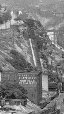
Fort Pitt Incline, Historical funicular in Bluff, Pittsburgh, United States.

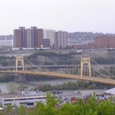
The Fort Pitt Incline was a funicular railway that extended 350 feet along a 135-foot elevation gain between Second Avenue and Bluff Street in Pittsburgh. This steep transport system connected the industrial riverfront area with the elevated residential neighborhood above.

The funicular began operations in 1882 and served commuters for roughly two decades before closing in 1900. A fire destroyed the abandoned infrastructure three years later.

The funicular served as a vital link for workers moving between the industrial riverfront and residential neighborhoods on the elevated Bluff. It shaped how Pittsburgh residents traveled and lived across different elevations of the city.

Today, public steps mark the former route of the incline, ascending from the Armstrong Tunnel south portal to the Boulevard of the Allies. Visitors can walk this path to follow the historical trajectory on foot.

The system initially relied on gravity for downhill movement and mules for uphill transport, a clever solution that combined natural forces with animal power. This hybrid approach made it an innovative experiment in 19th-century transportation engineering.

The community of curious travelers

AroundUs brings together thousands of curated places, local tips, and hidden gems, enriched daily by 60,000 contributors worldwide.

Start exploring
Location
Official opening
1882
GPS coordinates
40.43470,-79.98920
Latest update
December 14, 2025 12:23
Around this place
PPG Paints Arena
United States of America

PPG Paints Arena

523 m
Civic Arena
United States of America

Civic Arena

779 m
Allegheny County Courthouse
United States of America

Allegheny County Courthouse

715 m
BNY Mellon Center
United States of America

BNY Mellon Center

807 m
UPMC Cooper Fieldhouse
United States of America

UPMC Cooper Fieldhouse

320 m
Old Allegheny County Jail
United States of America

Old Allegheny County Jail

681 m
Pittsburgh City-County Building
United States of America

Pittsburgh City-County Building

754 m
South Tenth Street Bridge
United States of America

South Tenth Street Bridge

245 m
Panhandle Bridge
United States of America

Panhandle Bridge

775 m
Grant Building
United States of America

Grant Building

769 m
Washington Plaza
United States of America

Washington Plaza

694 m
Gumberg Library
United States of America

Gumberg Library

344 m
Richard King Mellon Hall
United States of America

Richard King Mellon Hall

227 m
Paramount Film Exchange
United States of America

Paramount Film Exchange

649 m
Duquesne University School of Nursing
United States of America

Duquesne University School of Nursing

515 m
St. John the Baptist Ukrainian Catholic Church
United States of America

St. John the Baptist Ukrainian Catholic Church

735 m
Allegheny County Office Building
United States of America

Allegheny County Office Building

656 m
United States of America

McAnulty College and Graduate School of Liberal Arts

352 m
Pittsburgh Terminal Properties
United States of America

Pittsburgh Terminal Properties

817 m
South Side Market Building
United States of America

South Side Market Building

641 m
Bedford School
United States of America

Bedford School

616 m
Garrison Foundry-Mackintosh Hemphill Company Offices
United States of America

Garrison Foundry-Mackintosh Hemphill Company Offices

580 m
Try Street Terminal
United States of America

Try Street Terminal

602 m
Allegheny County Mortuary
United States of America

Allegheny County Mortuary

652 m
Jones & Laughlin Headquarters Building
United States of America

Jones & Laughlin Headquarters Building

682 m
Liberty Bridge
United States of America

Liberty Bridge

678 m
Bridge of Sighs
United States of America

Bridge of Sighs

708 m
1904 South Tenth Street Bridge
United States of America

1904 South Tenth Street Bridge

243 m
Show the full map
« Fort Pitt Incline - Historical funicular in Bluff, Pittsburgh, United States » is provided by Around Us (aroundus.com). Images and texts are derived from Wikimedia project under a Creative Commons license. You are allowed to copy, distribute, and modify copies of this page, under the conditions set by the license, as long as this note is clearly visible.

Discover hidden gems everywhere you go!

From secret cafés to breathtaking viewpoints, skip the crowded tourist spots and find places that match your style. Our app makes it easy with voice search, smart filtering, route optimization, and insider tips from travelers worldwide. Download now for the complete mobile experience.

Around Us App Screenshot

A unique approach to discovering new places

Le Figaro

All the places worth exploring

France Info

A tailor-made excursion in just a few clicks

20 Minutes

Around Us
Travel Guide & Maps
Download

Send to your phone

QR Code
1

Open the camera app on your mobile.

2

Point at the QR code with your camera. A notification will appear.

3

Tap the notification to open the link.