Enable Location

We need your location to show you interesting places around you

Discover nearby places

Find interesting locations and hidden gems around you

Precise directions

Get accurate directions and distances to places

Your location is never shared with other users. It's only used when you tap the location button.

Gay Street School

Log in to your account

Start exploring — it's free

Trusted by 62,373 travelers worldwide

Continue with Google
Continue with Apple
or

We will send you a code to connect

By continuing, you accept our Terms and Conditions and our Privacy Policy

Check your inbox

We've sent a pincode in your inbox. Please enter the code below.

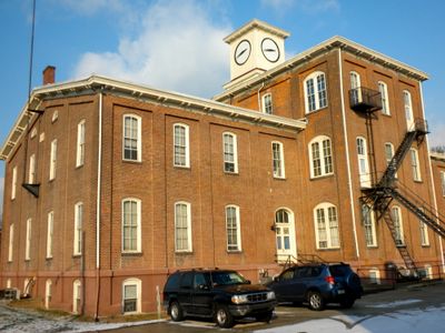
Gay Street School, Schule in den Vereinigten Staaten

Gay Street School is a historic brick school building in Phoenixville with a sturdy, simple design built for practical use. The original two-story west wing was built in 1874, and the structure was expanded in 1883 with an eastern section and a central tower section that added three stories.

The school was first built in 1874 as a two-story brick structure and was expanded in 1883 to accommodate more students with an eastern wing and central tower section. It was listed on the National Register of Historic Places in November 1983, officially recognizing its importance as part of Phoenixville's educational heritage.

Gay Street School served as a gathering place for the community and remains meaningful to Phoenixville residents who remember its role in local life. The building connects people to their shared past and the town's educational heritage in a way that residents still acknowledge today.

The building sits on the corner of Gay and Morgan Streets in a quiet residential neighborhood and is easy to reach while walking through Phoenixville. The location is peaceful, allowing you to view the historic structure and take in the surrounding area without crowds or distractions.

A clock and bell tower tops the building and once served the neighborhood as both a timekeeper and a signal for the school day, calling students to class and marking the end of lessons. This tower made the school a recognizable landmark that helped organize the daily rhythm of the community.

The community of curious travelers

AroundUs brings together thousands of curated places, local tips, and hidden gems, enriched daily by 60,000 contributors worldwide.

Start exploring
Location
GPS coordinates
40.13030,-75.51780
Latest update
February 9, 2026 07:45
Around this place
Schuylkill Canal
United States of America

Schuylkill Canal

1.3 km
Washington's Headquarters
United States of America

Washington's Headquarters

5.7 km
Colonial Theatre
United States of America

Colonial Theatre

424 m
Wharton Esherick Studio
United States of America

Wharton Esherick Studio

5.6 km
American Treasure Tour
United States of America

American Treasure Tour

5.3 km
St. Basil the Great, Kimberton
United States of America

St. Basil the Great, Kimberton

4.2 km
White Horse Farm
United States of America

White Horse Farm

1.7 km
Black Rock Bridge
United States of America

Black Rock Bridge

3.2 km
Moore Hall
United States of America

Moore Hall

2.1 km
Mont Clare Bridge
United States of America

Mont Clare Bridge

967 m
Gen. Frederick Von Steuben Headquarters
United States of America

Gen. Frederick Von Steuben Headquarters

5.3 km
Hares Hill Road Bridge
United States of America

Hares Hill Road Bridge

4.4 km
Rapps Bridge
United States of America

Rapps Bridge

3.1 km
Continental Stove Works
United States of America

Continental Stove Works

6.5 km
Moses Coates Jr. Farm
United States of America

Moses Coates Jr. Farm

1.6 km
Maj. Gen. Lord Stirling Quarters
United States of America

Maj. Gen. Lord Stirling Quarters

6.9 km
Kennedy Bridge
United States of America

Kennedy Bridge

5.1 km
Oskar G. Stonorov House
United States of America

Oskar G. Stonorov House

5.7 km
Charlestown Village Historic District
United States of America

Charlestown Village Historic District

4.8 km
French Creek Farm
United States of America

French Creek Farm

5.9 km
Kimberton Historic District
United States of America

Kimberton Historic District

5 km
Middle Pickering Rural Historic District
United States of America

Middle Pickering Rural Historic District

6.4 km
Matthias Pennypacker Farm
United States of America

Matthias Pennypacker Farm

2.4 km
John Williams Farm
United States of America

John Williams Farm

4.7 km
Prizer's Mill Complex
United States of America

Prizer's Mill Complex

4.9 km
Martin-Little House
United States of America

Martin-Little House

6.5 km
Wharton Esherick Museum
United States of America

Wharton Esherick Museum

5.6 km
Mill Grove
United States of America

Mill Grove

6.3 km
Show the full map
« Gay Street School - Schule in den Vereinigten Staaten » is provided by Around Us (aroundus.com). Images and texts are derived from Wikimedia project under a Creative Commons license. You are allowed to copy, distribute, and modify copies of this page, under the conditions set by the license, as long as this note is clearly visible.

Discover hidden gems everywhere you go!

From secret cafés to breathtaking viewpoints, skip the crowded tourist spots and find places that match your style. Our app makes it easy with voice search, smart filtering, route optimization, and insider tips from travelers worldwide. Download now for the complete mobile experience.

Around Us App Screenshot

A unique approach to discovering new places

Le Figaro

All the places worth exploring

France Info

A tailor-made excursion in just a few clicks

20 Minutes

Around Us
Travel Guide & Maps
Download

Send to your phone

QR Code
1

Open the camera app on your mobile.

2

Point at the QR code with your camera. A notification will appear.

3

Tap the notification to open the link.