Enable Location

We need your location to show you interesting places around you

Discover nearby places

Find interesting locations and hidden gems around you

Precise directions

Get accurate directions and distances to places

Your location is never shared with other users. It's only used when you tap the location button.

Goddard Covered Bridge

Log in to your account

Start exploring — it's free

Trusted by 61,907 travelers worldwide

Continue with Google
Continue with Apple
or

We will send you a code to connect

By continuing, you accept our Terms and Conditions and our Privacy Policy

Check your inbox

We've sent a pincode in your inbox. Please enter the code below.

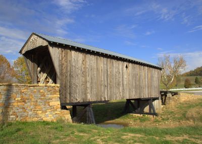
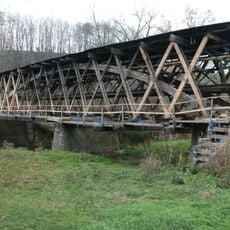
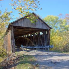
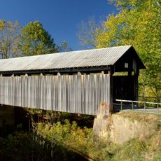
Goddard Covered Bridge, Covered bridge in Fleming County, US.

The Goddard Covered Bridge is a wooden lattice truss crossing Sand Lick Creek with a span of about 63 feet. The structure uses a traditional town lattice design fastened with wooden pins rather than nails, and steel reinforcement stabilizes the creek banks near its support points.

This bridge was built in 1864 by architect Joseph Goddard and is listed among historic sites in the region. In 1933, it was moved about one mile from its original location when Highway 32 was reconstructed.

This structure reflects how 19th-century rural communities in Kentucky depended on practical building techniques to connect distant settlements. Visitors walking across can sense how such bridges became central to local life and travel patterns of that era.

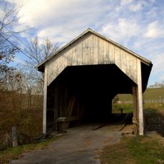
This crossing is designed for light vehicles, with a weight limit of about 4 tons for passage. Access is straightforward since the structure sits along a local road and can be reached easily on foot or by car.

The wooden covering shields the lattice framework from weather, allowing the timber to dry slowly and maintain strength over many decades. This protection was a practical way to extend the lifespan of wooden structures in a humid climate.

The community of curious travelers

AroundUs brings together thousands of curated places, local tips, and hidden gems, enriched daily by 60,000 contributors worldwide.

Start exploring
Location
Inception
1864
GPS coordinates
38.36222,-83.61556
Latest update
December 14, 2025 14:21
Around this place
Cave Run Lake
United States of America

Cave Run Lake

33.1 km
Blue Licks Battlefield State Park
United States of America

Blue Licks Battlefield State Park

33.9 km
Jayne Stadium
United States of America

Jayne Stadium

25.2 km
Simon Kenton Memorial Bridge
United States of America

Simon Kenton Memorial Bridge

34.4 km
Phillips' Folly
United States of America

Phillips' Folly

34.4 km
Kentucky Folk Art Center
United States of America

Kentucky Folk Art Center

25.7 km
Russell Theatre
United States of America

Russell Theatre

34.2 km
Johnson Creek Covered Bridge
United States of America

Johnson Creek Covered Bridge

34.2 km
Washington Historic District
United States of America

Washington Historic District

32.6 km
Cabin Creek Covered Bridge
United States of America

Cabin Creek Covered Bridge

27.5 km
Ringos Mill Covered Bridge
United States of America

Ringos Mill Covered Bridge

10.5 km
First Presbyterian Church
United States of America

First Presbyterian Church

12.6 km
Hillsboro Covered Bridge
United States of America

Hillsboro Covered Bridge

12.4 km
Confederate Monument in Owingsville
United States of America

Confederate Monument in Owingsville

27.5 km
Rowan County Courthouse
United States of America

Rowan County Courthouse

25.4 km
Cox-Hord House
United States of America

Cox-Hord House

33.9 km
Downtown Morehead Historic District
United States of America

Downtown Morehead Historic District

25.6 km
Elizaville Presbyterian Church
United States of America

Elizaville Presbyterian Church

19.3 km
Haldeman Voting House No. 8
United States of America

Haldeman Voting House No. 8

28.7 km
Raccoon John Smith House
United States of America

Raccoon John Smith House

27.7 km
Thomas Deye Owings House
United States of America

Thomas Deye Owings House

27.5 km
Poague House
United States of America

Poague House

25.2 km
May's Lick Negro School
United States of America

May's Lick Negro School

26 km
J.J. Nesbitt House
United States of America

J.J. Nesbitt House

27.7 km
Owingsville Commercial District and Courthouse Square
United States of America

Owingsville Commercial District and Courthouse Square

27.4 km
United States of America

Brushy Voting House No. 6

17.8 km
Limestone Historical Marker
United States of America

Limestone Historical Marker

34.4 km
Morehead State University
United States of America

Morehead State University

25.2 km
Show the full map
« Goddard Covered Bridge - Covered bridge in Fleming County, US » is provided by Around Us (aroundus.com). Images and texts are derived from Wikimedia project under a Creative Commons license. You are allowed to copy, distribute, and modify copies of this page, under the conditions set by the license, as long as this note is clearly visible.

Discover hidden gems everywhere you go!

From secret cafés to breathtaking viewpoints, skip the crowded tourist spots and find places that match your style. Our app makes it easy with voice search, smart filtering, route optimization, and insider tips from travelers worldwide. Download now for the complete mobile experience.

Around Us App Screenshot

A unique approach to discovering new places

Le Figaro

All the places worth exploring

France Info

A tailor-made excursion in just a few clicks

20 Minutes

Around Us
Travel Guide & Maps
Download

Send to your phone

QR Code
1

Open the camera app on your mobile.

2

Point at the QR code with your camera. A notification will appear.

3

Tap the notification to open the link.