Jayne Stadium

Log in to your account

AroundUs is a community-driven map of interesting places, built by curious explorers like you. It grows with every review, story, and photo you share.
Connect to save your favorite spots, contribute locations, and create personalized routes.
By continuing, you accept our Terms and Conditions and our Privacy Policy
Add to collection
Map
Suggest a change
Share

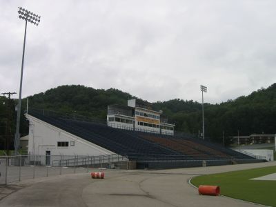
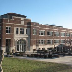
Jayne Stadium, Football stadium in Morehead, Kentucky, United States.

The 10,000-seat facility includes modern locker rooms, a spacious press box accommodating 20 media staff, and a film deck on the third floor.

Jayne Stadium, inaugurated in 1964, has continuously served as the primary athletic venue for Morehead State University Eagles football team since its establishment.

The stadium hosts numerous collegiate football matches throughout the season, bringing together students, alumni, and local community members to support their teams.

Located at 150 University Boulevard, the stadium features dedicated parking areas, accessible seating sections, and multiple concession stands throughout the facility.

The stadium's president's box on the second level provides space for fifty guests while offering direct views of the Astroturf GameDay Grass playing field.

Location: Kentucky

Inception: 1964

Official opening: 1964

Capacity: 10000

GPS coordinates: 38.19190,-83.42530

Latest update: September 23, 2025 14:06

Around this place
Show the full map
Red River Gorge
United States of America

Red River Gorge

42.9 km
Cave Run Lake
United States of America

Cave Run Lake

12.2 km
Carter Caves State Resort Park
United States of America

Carter Caves State Resort Park

33.4 km
Grayson Lake
United States of America

Grayson Lake

39.2 km
Grayson Lake State Park
United States of America

Grayson Lake State Park

35.8 km
Bat Cave and Cascade Caverns State Nature Preserves
United States of America

Bat Cave and Cascade Caverns State Nature Preserves

32.9 km
Kentucky Folk Art Center
United States of America

Kentucky Folk Art Center

1.5 km
Elliott County Kimberlite
United States of America

Elliott County Kimberlite

38.8 km
Clifty Wilderness
United States of America

Clifty Wilderness

42.2 km
Goddard Covered Bridge
United States of America

Goddard Covered Bridge

25.2 km
Saltpeter Cave
United States of America

Saltpeter Cave

33.4 km
Ringos Mill Covered Bridge
United States of America

Ringos Mill Covered Bridge

18.3 km
First Presbyterian Church
United States of America

First Presbyterian Church

37.5 km
Hillsboro Covered Bridge
United States of America

Hillsboro Covered Bridge

21.1 km
Confederate Monument in Owingsville
United States of America

Confederate Monument in Owingsville

29.8 km
Rowan County Courthouse
United States of America

Rowan County Courthouse

1.1 km
Downtown Morehead Historic District
United States of America

Downtown Morehead Historic District

1.6 km
Elizaville Presbyterian Church
United States of America

Elizaville Presbyterian Church

43 km
Haldeman Voting House No. 8
United States of America

Haldeman Voting House No. 8

10.6 km
Raccoon John Smith House
United States of America

Raccoon John Smith House

30.5 km
Thomas Deye Owings House
United States of America

Thomas Deye Owings House

30.2 km
Judge John E. Cooper House
United States of America

Judge John E. Cooper House

33.2 km
J.J. Nesbitt House
United States of America

J.J. Nesbitt House

30.4 km
Owingsville Commercial District and Courthouse Square
United States of America

Owingsville Commercial District and Courthouse Square

30.1 km
Brushy Voting House No. 6
United States of America

Brushy Voting House No. 6

7.8 km
Morgan County Courthouse
United States of America

Morgan County Courthouse

33.6 km
Double Arch
United States of America

Double Arch

45.6 km
Morehead State University
United States of America

Morehead State University

970 m
Show the full map

Reviews

Visited this place? Tap the stars to rate it and share your experience / photos with the community! Try now! You can cancel it anytime.

« Jayne Stadium: Football stadium in Morehead, Kentucky, United States » is provided by Around Us (aroundus.com). Images and texts are derived from Wikimedia project under a Creative Commons license. You are allowed to copy, distribute, and modify copies of this page, under the conditions set by the license, as long as this note is clearly visible.

Discover hidden gems everywhere you go!

From secret cafés to breathtaking viewpoints, skip the crowded tourist spots and find places that match your style. Our app makes it easy with voice search, smart filtering, route optimization, and insider tips from travelers worldwide. Download now for the complete mobile experience.

Around Us App Screenshot

A unique approach to discovering new places

Le Figaro

All the places worth exploring

France Info

A tailor-made excursion in just a few clicks

20 Minutes