Bat Cave and Cascade Caverns State Nature Preserves

Log in to your account

AroundUs is a community-driven map of interesting places, built by curious explorers like you. It grows with every review, story, and photo you share.
Connect to save your favorite spots, contribute locations, and create personalized routes.
Continue with Google
Continue with Apple
Continue with X
Continue with Facebook
Continue with email
By continuing, you accept our Terms and Conditions and our Privacy Policy
Create an account

Bat Cave and Cascade Caverns State Nature Preserves

Add to collection
Map
Suggest a change
Share

Bat Cave and Cascade Caverns State Nature Preserves, Protected area in Carter County, Kentucky, US

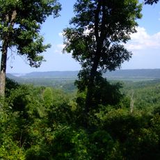
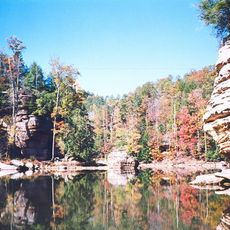
Bat Cave and Cascade Caverns State Nature Preserves is a protected area with underground cave systems and limestone formations in Kentucky. The site contains multiple caverns featuring waterfalls and natural stone passages created over millions of years.

The area was officially designated as a protected site in 1981 to preserve the bat population living in the caves. This decision was part of a broader conservation effort for endangered species in the Kentucky region.

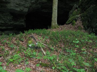
The name Cascade Caverns refers to the waterfalls flowing through the cave passages that formed in limestone. Visitors walking through the area can observe natural stone formations shaped by water over time.

Visitors should know that access to certain areas is limited to protect the bat population from disturbance. The best time to explore is outside breeding seasons when fewer restrictions apply.

One special feature is the cool microclimate at cave entrances that allows rare plant species like Canadian yew to grow in this region. These cold air currents create an environment that differs completely from typical Kentucky conditions.

Location: Carter County

Inception: 1981

GPS coordinates: 38.35583,-83.11139

Latest update: December 13, 2025 11:41

Photos
Around this place
Carter Caves State Resort Park
United States of America

Carter Caves State Resort Park

2.2 km
Lower Shawneetown
United States of America

Lower Shawneetown

41.4 km
Grayson Lake
United States of America

Grayson Lake

16.1 km
Jayne Stadium
United States of America

Jayne Stadium

32.9 km
Ironton–Russell Bridge
United States of America

Ironton–Russell Bridge

41.7 km
Shawnee State Forest
United States of America

Shawnee State Forest

37.6 km
Greenup Lock and Dam
United States of America

Greenup Lock and Dam

39.2 km
Grayson Lake State Park
United States of America

Grayson Lake State Park

17.6 km
Greenbo Lake
United States of America

Greenbo Lake

26.1 km
Kentucky Folk Art Center
United States of America

Kentucky Folk Art Center

34.3 km
Union Monument in Vanceburg
United States of America

Union Monument in Vanceburg

32.6 km
Elliott County Kimberlite
United States of America

Elliott County Kimberlite

27.3 km
Jesse Stuart Memorial Bridge
United States of America

Jesse Stuart Memorial Bridge

39.1 km
Adams County Paleo-Indian District
United States of America

Adams County Paleo-Indian District

32.8 km
Saltpeter Cave
United States of America

Saltpeter Cave

2.5 km
Bennett's Mill Covered Bridge
United States of America

Bennett's Mill Covered Bridge

34.5 km
Oldtown Covered Bridge
United States of America

Oldtown Covered Bridge

20.7 km
Rowan County Courthouse
United States of America

Rowan County Courthouse

34 km
Downtown Morehead Historic District
United States of America

Downtown Morehead Historic District

34.4 km
Haldeman Voting House No. 8
United States of America

Haldeman Voting House No. 8

22.3 km
Wurtland Union Church
United States of America

Wurtland Union Church

36 km
Greenup Masonic Lodge
United States of America

Greenup Masonic Lodge

34.4 km
Methodist Episcopal Church South
United States of America

Methodist Episcopal Church South

34.5 km
United States of America

Brushy Voting House No. 6

36.6 km
Marlow Theater
United States of America

Marlow Theater

42.2 km
Morehead State University
United States of America

Morehead State University

33.9 km
Portsmouth Earthworks, Group A
United States of America

Portsmouth Earthworks, Group A

41.4 km
Hopewell Bridge
United States of America

Hopewell Bridge

18.9 km
Show the full map
Reviews

Visited this place? Tap the stars to rate it and share your experience / photos with the community! Try now! You can cancel it anytime.

« Bat Cave and Cascade Caverns State Nature Preserves - Protected area in Carter County, Kentucky, US » is provided by Around Us (aroundus.com). Images and texts are derived from Wikimedia project under a Creative Commons license. You are allowed to copy, distribute, and modify copies of this page, under the conditions set by the license, as long as this note is clearly visible.

Discover hidden gems everywhere you go!

From secret cafés to breathtaking viewpoints, skip the crowded tourist spots and find places that match your style. Our app makes it easy with voice search, smart filtering, route optimization, and insider tips from travelers worldwide. Download now for the complete mobile experience.

Around Us App Screenshot

A unique approach to discovering new places

Le Figaro

All the places worth exploring

France Info

A tailor-made excursion in just a few clicks

20 Minutes