Enable Location

We need your location to show you interesting places around you

Discover nearby places

Find interesting locations and hidden gems around you

Precise directions

Get accurate directions and distances to places

Your location is never shared with other users. It's only used when you tap the location button.

Elliott County Kimberlite

Log in to your account

Start exploring — it's free

Trusted by 61,705 travelers worldwide

Continue with Google
Continue with Apple
or

We will send you a code to connect

By continuing, you accept our Terms and Conditions and our Privacy Policy

Check your inbox

We've sent a pincode in your inbox. Please enter the code below.

Elliott County Kimberlite

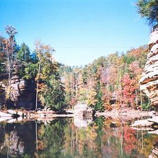
Elliott County Kimberlite, Kimberlite geological formation in northeastern Kentucky, United States.

Description

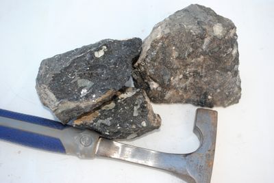
Elliott County Kimberlite is a geological formation in northeastern Kentucky composed of three elongated bodies of dark-green peridotite rock. The formation spans roughly one square kilometer and contains minerals such as olivine, phlogopite, pyrope, and ilmenite distributed throughout the intrusive bodies.

History

Albert R. Crandall identified this geological formation in 1884, before similar kimberlite rocks were recognized near Kimberley in South Africa. The discovery contributed to early understanding of these unusual magmatic structures found in North America.

Culture

The site attracts geologists and mineral collectors who study its composition of serpentinized olivine, phlogopite, pyrope, calcite, and magnesian ilmenite.

Practical

Access to the site requires permission because portions may be on private land and are not freely accessible. Visitors should check in advance about conditions and whether viewing the formation is permitted.

Did you know?

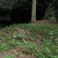
The rock weathers extensively, penetrating up to 50 feet (15 meters) into the ground where it transforms into yellowish-brown saprolite. Garnet fragments appear scattered within this weathered zone, marking the advanced age of the formation.

Location
GPS coordinates
38.13040,-82.98880
Latest update
December 14, 2025 11:24

AroundUs brings together thousands of curated places, local tips, and hidden gems, enriched daily by 60,000 contributors worldwide. Discover all places nearby (Kentucky).

Around this place
Carter Caves State Resort Park
United States of America

Carter Caves State Resort Park

29.5 km
U.S. 23 Country Music Highway Museum
United States of America

U.S. 23 Country Music Highway Museum

36.3 km
Grayson Lake
United States of America

Grayson Lake

13.5 km
Paintsville Lake
United States of America

Paintsville Lake

32 km
Mayo Mansion
United States of America

Mayo Mansion

38.4 km
Grayson Lake State Park
United States of America

Grayson Lake State Park

9.9 km
Paintsville Lake State Park
United States of America

Paintsville Lake State Park

34 km
Yatesville Lake State Park
United States of America

Yatesville Lake State Park

27 km
Mountain Homeplace
United States of America

Mountain Homeplace

34.1 km
Bat Cave and Cascade Caverns State Nature Preserves
United States of America

Bat Cave and Cascade Caverns State Nature Preserves

27.3 km
First United Methodist Church
United States of America

First United Methodist Church

38.6 km
Saltpeter Cave
United States of America

Saltpeter Cave

29.8 km
Johnson County Public Library
United States of America

Johnson County Public Library

38.7 km
Fred M. Vinson Birthplace
United States of America

Fred M. Vinson Birthplace

33.9 km
David McKenzie Log Cabin
United States of America

David McKenzie Log Cabin

28.4 km
Oldtown Covered Bridge
United States of America

Oldtown Covered Bridge

34.5 km
First United Methodist Church
United States of America

First United Methodist Church

33.6 km
Louisa United Methodist Church
United States of America

Louisa United Methodist Church

33.9 km
Paintsville Public Library Building
United States of America

Paintsville Public Library Building

38.6 km
H.B. Rice Insurance Building
United States of America

H.B. Rice Insurance Building

38.7 km
Captain Freese House
United States of America

Captain Freese House

33.5 km
Haldeman Voting House No. 8
United States of America

Haldeman Voting House No. 8

31.9 km
Louisa Commercial Historic District
United States of America

Louisa Commercial Historic District

33.8 km
Judge John E. Cooper House
United States of America

Judge John E. Cooper House

33 km
Big Sandy Milling Company
United States of America

Big Sandy Milling Company

33.6 km
Atkins–Carter House
United States of America

Atkins–Carter House

33.9 km
Morgan County Courthouse
United States of America

Morgan County Courthouse

33.1 km
Hopewell Bridge
United States of America

Hopewell Bridge

31.8 km
Show the full map
« Elliott County Kimberlite - Kimberlite geological formation in northeastern Kentucky, United States » is provided by Around Us (aroundus.com). Images and texts are derived from Wikimedia project under a Creative Commons license. You are allowed to copy, distribute, and modify copies of this page, under the conditions set by the license, as long as this note is clearly visible.

Discover hidden gems everywhere you go!

From secret cafés to breathtaking viewpoints, skip the crowded tourist spots and find places that match your style. Our app makes it easy with voice search, smart filtering, route optimization, and insider tips from travelers worldwide. Download now for the complete mobile experience.

Around Us App Screenshot

A unique approach to discovering new places

Le Figaro

All the places worth exploring

France Info

A tailor-made excursion in just a few clicks

20 Minutes

Around Us
Travel Guide & Maps
Download

Send to your phone

QR Code
1

Open the camera app on your mobile.

2

Point at the QR code with your camera. A notification will appear.

3

Tap the notification to open the link.