Enable Location

We need your location to show you interesting places around you

Discover nearby places

Find interesting locations and hidden gems around you

Precise directions

Get accurate directions and distances to places

Your location is never shared with other users. It's only used when you tap the location button.

Grayson Lake

Log in to your account

Start exploring — it's free

Trusted by 62,558 travelers worldwide

Continue with Google
Continue with Apple
or

We will send you a code to connect

By continuing, you accept our Terms and Conditions and our Privacy Policy

Check your inbox

We've sent a pincode in your inbox. Please enter the code below.

Grayson Lake

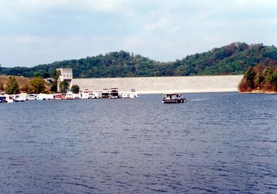
Grayson Lake, body of water

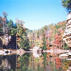
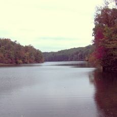
Grayson Lake is a narrow reservoir carved into the land along Kentucky's Little Sandy River, with steep sandstone cliffs that rise as high as 200 feet in places. The water covers more than a thousand acres and is lined with densely forested shores featuring beech and hemlock trees, with several waterfalls flowing into the lake.

The lake was built by the U.S. Army Corps of Engineers in the 1960s to control flooding on the Little Sandy River, using an earthen and rock dam roughly 120 feet tall. The flooding required the relocation of cemeteries, including the Old Mobley Cemetery in 1966, and changed traditional settlement patterns in the region.

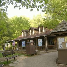
The lake bears the name of the nearby town of Grayson and serves as a gathering place for outdoor enthusiasts and local communities today. Families and nature lovers regularly visit to paddle, hike, and observe wildlife, making it a focal point for people seeking time in nature.

The lake is accessible from the south via Kentucky Route 7 and offers free access without entrance fees or boat rentals on site. Bring your own boat, pack plenty of water and sunscreen, and visit during warmer months when water levels are highest and conditions are ideal for paddling activities.

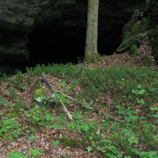
Paddlers report discovering hidden caves and waterfalls such as the Grotto and Hidden Falls, where secret coves hide behind fractured sandstone rocks. These tucked-away spots are unmarked and require local knowledge or exploration to find.

The community of curious travelers

AroundUs brings together thousands of curated places, local tips, and hidden gems, enriched daily by 60,000 contributors worldwide.

Start exploring
Location
GPS coordinates
38.25153,-82.98386
Latest update
February 7, 2026 11:00
Around this place
Carter Caves State Resort Park
United States of America

Carter Caves State Resort Park

18.2 km
Jayne Stadium
United States of America

Jayne Stadium

39.2 km
Paramount Arts Center
United States of America

Paramount Arts Center

39.1 km
Grayson Lake State Park
United States of America

Grayson Lake State Park

4.9 km
Yatesville Lake State Park
United States of America

Yatesville Lake State Park

32 km
Greenbo Lake
United States of America

Greenbo Lake

28.6 km
Bat Cave and Cascade Caverns State Nature Preserves
United States of America

Bat Cave and Cascade Caverns State Nature Preserves

16.1 km
Elliott County Kimberlite
United States of America

Elliott County Kimberlite

13.5 km
Saltpeter Cave
United States of America

Saltpeter Cave

18.5 km
Fred M. Vinson Birthplace
United States of America

Fred M. Vinson Birthplace

36.7 km
St. Paul's Lutheran Church
United States of America

St. Paul's Lutheran Church

38.8 km
First Presbyterian Church
United States of America

First Presbyterian Church

39.2 km
Oldtown Covered Bridge
United States of America

Oldtown Covered Bridge

21.5 km
First United Methodist Church
United States of America

First United Methodist Church

37.9 km
St. James AME Church
United States of America

St. James AME Church

39 km
First United Methodist Church
United States of America

First United Methodist Church

36.4 km
Louisa United Methodist Church
United States of America

Louisa United Methodist Church

36.7 km
Captain Freese House
United States of America

Captain Freese House

36.1 km
Wurtland Union Church
United States of America

Wurtland Union Church

37.7 km
Haldeman Voting House No. 8
United States of America

Haldeman Voting House No. 8

29.7 km
Bath Avenue Historic District
United States of America

Bath Avenue Historic District

38.9 km
Culbertson House
United States of America

Culbertson House

38.6 km
Louisa Commercial Historic District
United States of America

Louisa Commercial Historic District

36.6 km
Greenup Masonic Lodge
United States of America

Greenup Masonic Lodge

38.5 km
Big Sandy Milling Company
United States of America

Big Sandy Milling Company

36.3 km
Methodist Episcopal Church South
United States of America

Methodist Episcopal Church South

38.5 km
Atkins–Carter House
United States of America

Atkins–Carter House

36.7 km
Hopewell Bridge
United States of America

Hopewell Bridge

18.7 km
Show the full map
« Grayson Lake - body of water » is provided by Around Us (aroundus.com). Images and texts are derived from Wikimedia project under a Creative Commons license. You are allowed to copy, distribute, and modify copies of this page, under the conditions set by the license, as long as this note is clearly visible.

Discover hidden gems everywhere you go!

From secret cafés to breathtaking viewpoints, skip the crowded tourist spots and find places that match your style. Our app makes it easy with voice search, smart filtering, route optimization, and insider tips from travelers worldwide. Download now for the complete mobile experience.

Around Us App Screenshot

A unique approach to discovering new places

Le Figaro

All the places worth exploring

France Info

A tailor-made excursion in just a few clicks

20 Minutes

Around Us
Travel Guide & Maps
Download

Send to your phone

QR Code
1

Open the camera app on your mobile.

2

Point at the QR code with your camera. A notification will appear.

3

Tap the notification to open the link.