Enable Location

We need your location to show you interesting places around you

Discover nearby places

Find interesting locations and hidden gems around you

Precise directions

Get accurate directions and distances to places

Your location is never shared with other users. It's only used when you tap the location button.

Hannibal Locks and Dam

Log in to your account

Start exploring — it's free

Trusted by 62,520 travelers worldwide

Continue with Google
Continue with Apple
or

We will send you a code to connect

By continuing, you accept our Terms and Conditions and our Privacy Policy

Check your inbox

We've sent a pincode in your inbox. Please enter the code below.

Hannibal Locks and Dam

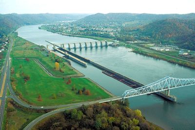
Hannibal Locks and Dam, Lock and gravity dam system on the Ohio River in Monroe and Wetzel counties, United States.

This engineering facility features a gravity dam structure combined with lock chambers that enable vessel passage along the Ohio River while managing water levels and flow rates for navigation safety.

Constructed by the U.S. Army Corps of Engineers as part of early 20th century river improvement projects, the facility has undergone upgrades to accommodate modern vessels and enhance operational capacity.

The site represents the industrial heritage of Ohio River transportation, serving as a testament to American engineering achievements in waterway management and commercial river navigation development.

The facility operates continuously under Army Corps supervision, providing real-time water level data through USGS monitoring systems while maintaining navigation channels for commercial and recreational vessel traffic.

The structure incorporates a historic maneuver boat and wicket dam system that demonstrates traditional river management techniques, offering visitors educational insights into inland waterway engineering evolution.

The community of curious travelers

AroundUs brings together thousands of curated places, local tips, and hidden gems, enriched daily by 60,000 contributors worldwide.

Start exploring
Location
Location
GPS coordinates
39.66700,-80.86590
Latest update
July 25, 2025 22:30
Around this place
West Virginia Penitentiary
United States of America

West Virginia Penitentiary

29.7 km
Grave Creek Mound
United States of America

Grave Creek Mound

29.7 km
Moundsville Bridge
United States of America

Moundsville Bridge

29 km
William C. Mooney House
United States of America

William C. Mooney House

23.7 km
New Martinsville Bridge
United States of America

New Martinsville Bridge

896 m
Monroe County Courthouse
United States of America

Monroe County Courthouse

24 km
Frederick Kindleberger Stone House and Barn
United States of America

Frederick Kindleberger Stone House and Barn

18.5 km
Knowlton Covered Bridge
United States of America

Knowlton Covered Bridge

26 km
Fish Creek Covered Bridge
United States of America

Fish Creek Covered Bridge

35.4 km
Monroe Bank
United States of America

Monroe Bank

23.9 km
Cameron Downtown
United States of America

Cameron Downtown

31.2 km
Rinard Covered Bridge
United States of America

Rinard Covered Bridge

33.9 km
E. A. Durham House
United States of America

E. A. Durham House

17.3 km
Bennett Cockayne House
United States of America

Bennett Cockayne House

32.1 km
Tyler County Courthouse and Jail
United States of America

Tyler County Courthouse and Jail

19.8 km
Foreaker Covered Bridge
United States of America

Foreaker Covered Bridge

21.9 km
Salem Church
United States of America

Salem Church

7.2 km
Hollister-Parry House
United States of America

Hollister-Parry House

23.5 km
Wells-Schaff House
United States of America

Wells-Schaff House

17.1 km
North Street Historic District
United States of America

North Street Historic District

2.8 km
Bushrod Washington Price House
United States of America

Bushrod Washington Price House

30.7 km
Sistersville Historic District
United States of America

Sistersville Historic District

15.9 km
New Martinsville Downtown Historic District
United States of America

New Martinsville Downtown Historic District

3 km
Sistersville City Hall
United States of America

Sistersville City Hall

16 km
William Wells House
United States of America

William Wells House

26.1 km
Moundsville Commercial Historic District
United States of America

Moundsville Commercial Historic District

30 km
Ferrell-Holt House
United States of America

Ferrell-Holt House

29.9 km
Middlebourne Historic District
United States of America

Middlebourne Historic District

19.8 km
Show the full map
« Hannibal Locks and Dam - Lock and gravity dam system on the Ohio River in Monroe and Wetzel counties, United States » is provided by Around Us (aroundus.com). Images and texts are derived from Wikimedia project under a Creative Commons license. You are allowed to copy, distribute, and modify copies of this page, under the conditions set by the license, as long as this note is clearly visible.

Discover hidden gems everywhere you go!

From secret cafés to breathtaking viewpoints, skip the crowded tourist spots and find places that match your style. Our app makes it easy with voice search, smart filtering, route optimization, and insider tips from travelers worldwide. Download now for the complete mobile experience.

Around Us App Screenshot

A unique approach to discovering new places

Le Figaro

All the places worth exploring

France Info

A tailor-made excursion in just a few clicks

20 Minutes

Around Us
Travel Guide & Maps
Download

Send to your phone

QR Code
1

Open the camera app on your mobile.

2

Point at the QR code with your camera. A notification will appear.

3

Tap the notification to open the link.