Harshaville Covered Bridge

Log in to your account

AroundUs is a community-driven map of interesting places, built by curious explorers like you. It grows with every review, story, and photo you share.
Connect to save your favorite spots, contribute locations, and create personalized routes.
Continue with Google
Continue with Apple
Continue with X
Continue with Facebook
Continue with email
By continuing, you accept our Terms and Conditions and our Privacy Policy
Create an account
Add to collection
Map
Suggest a change
Share

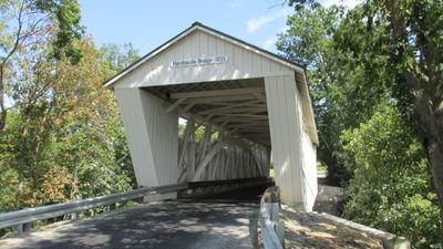
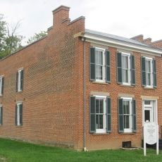
Harshaville Covered Bridge, Covered bridge in Adams County, Ohio, United States

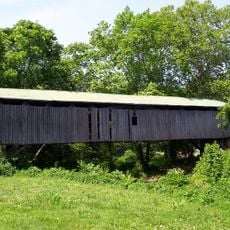
Harshaville Covered Bridge spans about 110 feet (33 meters) across a creek using a sturdy wooden frame with sheet metal siding and metal roofing. Stone piers on both sides support the entire structure, allowing it to handle vehicle traffic since its completion.

The structure was built in 1855 using the Burr truss design, a construction method popular at the time. During the American Civil War, it endured while armies moved through the region.

The bridge carries the Harsha family name, who built a mill nearby and shaped the local community's growth. It represents the trade connections that defined this part of Ohio in the 1800s.

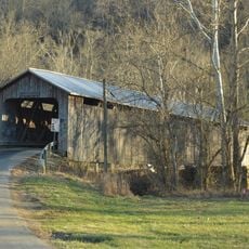
The bridge is accessible by vehicle but remains unpaved, requiring careful driving in wet conditions. Visitors should come on dry days when the approach roads are passable.

It is the only historic covered bridge in Adams County still serving vehicle traffic and maintaining its original purpose. This continuous use for over a century makes it a rare example of infrastructure that remembers its roots.

Location: Adams County

GPS coordinates: 38.90780,-83.54440

Latest update: December 14, 2025 18:00

Photos
Around this place
Serpent Mound
United States of America

Serpent Mound

16.4 km
Serpent Mound crater
United States of America

Serpent Mound crater

18.7 km
John Rankin House
United States of America

John Rankin House

31.2 km
Ohio River Islands National Wildlife Refuge
United States of America

Ohio River Islands National Wildlife Refuge

24.8 km
Rocky Fork State Park
United States of America

Rocky Fork State Park

31.6 km
Grant Boyhood Home
United States of America

Grant Boyhood Home

31.4 km
William H. Harsha Bridge
United States of America

William H. Harsha Bridge

32.3 km
Adams Lake State Park
United States of America

Adams Lake State Park

10.5 km
Serpent Mound State Memorial
United States of America

Serpent Mound State Memorial

16.4 km
John P. Parker House
United States of America

John P. Parker House

31.7 km
Adams County Courthouse
United States of America

Adams County Courthouse

12.7 km
Brown County Courthouse
United States of America

Brown County Courthouse

31.5 km
Chaparral Prairie State Nature Preserve
United States of America

Chaparral Prairie State Nature Preserve

8 km
Rocky Fork Park Site
United States of America

Rocky Fork Park Site

29.5 km
Buckeye Station
United States of America

Buckeye Station

22.5 km
Otway Covered Bridge
United States of America

Otway Covered Bridge

31.1 km
North Pole Road Covered Bridge
United States of America

North Pole Road Covered Bridge

26.5 km
Pisgah Christian Church
United States of America

Pisgah Christian Church

32.3 km
Kirker Covered Bridge
United States of America

Kirker Covered Bridge

14.7 km
Eagle Creek Covered Bridge
United States of America

Eagle Creek Covered Bridge

21.3 km
Georgetown Historic District
United States of America

Georgetown Historic District

31.5 km
Bailey-Thompson House
United States of America

Bailey-Thompson House

31.3 km
Sutton House
United States of America

Sutton House

17 km
US Grant Boyhood Home and Schoolhouse
United States of America

US Grant Boyhood Home and Schoolhouse

31.3 km
Peebles
United States of America

Peebles

13.1 km
The Bentonville Anti-Horse Thief Society
United States of America

The Bentonville Anti-Horse Thief Society

18.4 km
Serpent Mound
United States of America

Serpent Mound

16.3 km
Ripley
United States of America

Ripley

31.8 km
Show the full map
Reviews

Visited this place? Tap the stars to rate it and share your experience / photos with the community! Try now! You can cancel it anytime.

« Harshaville Covered Bridge - Covered bridge in Adams County, Ohio, United States » is provided by Around Us (aroundus.com). Images and texts are derived from Wikimedia project under a Creative Commons license. You are allowed to copy, distribute, and modify copies of this page, under the conditions set by the license, as long as this note is clearly visible.

Discover hidden gems everywhere you go!

From secret cafés to breathtaking viewpoints, skip the crowded tourist spots and find places that match your style. Our app makes it easy with voice search, smart filtering, route optimization, and insider tips from travelers worldwide. Download now for the complete mobile experience.

Around Us App Screenshot

A unique approach to discovering new places

Le Figaro

All the places worth exploring

France Info

A tailor-made excursion in just a few clicks

20 Minutes