Enable Location

We need your location to show you interesting places around you

Discover nearby places

Find interesting locations and hidden gems around you

Precise directions

Get accurate directions and distances to places

Your location is never shared with other users. It's only used when you tap the location button.

Henderson Bridge

Log in to your account

Start exploring — it's free

Trusted by 61,629 travelers worldwide

Continue with Google
Continue with Apple
or

We will send you a code to connect

By continuing, you accept our Terms and Conditions and our Privacy Policy

Check your inbox

We've sent a pincode in your inbox. Please enter the code below.

Henderson Bridge

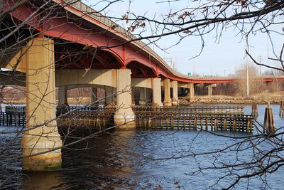
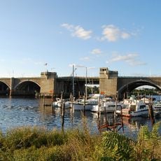
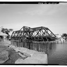
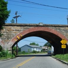
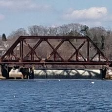
Henderson Bridge, Steel bridge across Seekonk River, Rhode Island

Description

Henderson Bridge is a steel structure that spans the Seekonk River and links Providence's East Side to neighborhoods in East Providence. The crossing accommodates three traffic lanes plus a dedicated path for pedestrians and cyclists.

History

Engineer George Henderson designed this bridge in 1969 as a replacement for the Red Bridge built in 1895, continuing a long succession of crossings at this location. The site had seen several generations of bridge construction since 1793, each responding to changing transportation needs.

Culture

The bridge reconstruction project reflects Rhode Island's commitment to modernizing infrastructure while preserving connections between long-established communities on both sides of the river.

Practical

The bridge features a protected area for cyclists and pedestrians that connects to existing bicycle networks on both sides of the river. Visitors should note that the post-2023 renovation improvements make crossing more comfortable and accessible.

Did you know?

During its recent overhaul, the bridge was reduced from six traffic lanes to three, freeing substantial land for new development along the riverfront. This scaling down also dramatically changed the visual presence of the structure in relation to the surrounding area.

Location
Made from material
steel
GPS coordinates
41.82930,-71.37780
Latest update
December 12, 2025 09:03

AroundUs brings together thousands of curated places, local tips, and hidden gems, enriched daily by 60,000 contributors worldwide. Discover all places nearby (Rhode Island).

Around this place
Brown Stadium
United States of America

Brown Stadium

2 km
Meehan Auditorium
United States of America

Meehan Auditorium

1.8 km
Crook Point Bascule Bridge
United States of America

Crook Point Bascule Bridge

855 m
India Point Park
United States of America

India Point Park

1.8 km
Pizzitola Sports Center
United States of America

Pizzitola Sports Center

1.7 km
Lindemann Performing Arts Center
United States of America

Lindemann Performing Arts Center

2.1 km
Washington Bridge
United States of America

Washington Bridge

1.4 km
Nelson W. Aldrich House
United States of America

Nelson W. Aldrich House

1.6 km
Sayles Memorial Hall
United States of America

Sayles Memorial Hall

2.1 km
United States of America

Wayland Square

833 m
India Point Railroad Bridge
United States of America

India Point Railroad Bridge

1.6 km
Governor Henry Lippitt House
United States of America

Governor Henry Lippitt House

1.7 km
Phillip Walker House
United States of America

Phillip Walker House

1.2 km
United States of America

Bold Point

1.9 km
World War I Memorial
United States of America

World War I Memorial

1.2 km
Oddfellows' Hall
United States of America

Oddfellows' Hall

1.4 km
Boston and Providence Railroad Bridge
United States of America

Boston and Providence Railroad Bridge

1.4 km
Wayland Historic District
United States of America

Wayland Historic District

679 m
Blackstone Park Historic District
United States of America

Blackstone Park Historic District

490 m
Freeman Plat Historic District
United States of America

Freeman Plat Historic District

1.7 km
Stimson Avenue Historic District
United States of America

Stimson Avenue Historic District

1.5 km
Nathaniel Pearce House
United States of America

Nathaniel Pearce House

1.8 km
Omega Pond Railroad Bridge
United States of America

Omega Pond Railroad Bridge

1.3 km
Blackstone Boulevard–Cole Avenue–Grotto Avenue Historic District
United States of America

Blackstone Boulevard–Cole Avenue–Grotto Avenue Historic District

1.3 km
Olney Street-Alumni Avenue Historic District
United States of America

Olney Street-Alumni Avenue Historic District

1.8 km
Ladd Observatory
United States of America

Ladd Observatory

2.1 km
Lippitt House Museum
United States of America

Lippitt House Museum

1.6 km
Nathaniel Daggett House
United States of America

Nathaniel Daggett House

1.6 km
Show the full map
« Henderson Bridge - Steel bridge across Seekonk River, Rhode Island » is provided by Around Us (aroundus.com). Images and texts are derived from Wikimedia project under a Creative Commons license. You are allowed to copy, distribute, and modify copies of this page, under the conditions set by the license, as long as this note is clearly visible.

Discover hidden gems everywhere you go!

From secret cafés to breathtaking viewpoints, skip the crowded tourist spots and find places that match your style. Our app makes it easy with voice search, smart filtering, route optimization, and insider tips from travelers worldwide. Download now for the complete mobile experience.

Around Us App Screenshot

A unique approach to discovering new places

Le Figaro

All the places worth exploring

France Info

A tailor-made excursion in just a few clicks

20 Minutes

Around Us
Travel Guide & Maps
Download

Send to your phone

QR Code
1

Open the camera app on your mobile.

2

Point at the QR code with your camera. A notification will appear.

3

Tap the notification to open the link.