Enable Location

We need your location to show you interesting places around you

Discover nearby places

Find interesting locations and hidden gems around you

Precise directions

Get accurate directions and distances to places

Your location is never shared with other users. It's only used when you tap the location button.

Crook Point Bascule Bridge

Log in to your account

Start exploring — it's free

Trusted by 61,634 travelers worldwide

Continue with Google
Continue with Apple
or

We will send you a code to connect

By continuing, you accept our Terms and Conditions and our Privacy Policy

Check your inbox

We've sent a pincode in your inbox. Please enter the code below.

Crook Point Bascule Bridge

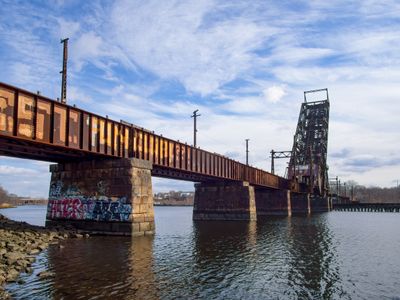
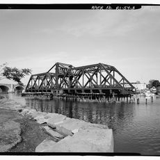
Crook Point Bascule Bridge, Railway bridge in Providence, United States.

Description

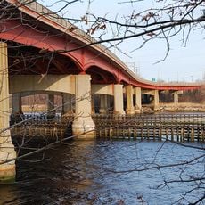
Crook Point Bascule Bridge is a steel railway bridge spanning the Seekonk River and connecting Providence's Fox Point neighborhood to East Providence. The structure extends for approximately 850 feet with its longest span reaching about 125 feet and was engineered to allow rail traffic to cross between the two riverbanks.

History

The bridge was completed in 1908 as part of the East Side Railroad Tunnel project, connecting the New York, New Haven and Hartford Railroad lines to Providence Union Station. It served as an important link in the region's rail network until passenger service declined and the structure was eventually taken out of service.

Culture

The abandoned structure in its raised position has become a fixed landmark in Providence's skyline, drawing people who want to see the industrial architecture along the river. Today, visitors use the surrounding area to walk and photograph the bridge, as it stands as a reminder of when this location was a vital transportation hub.

Practical

Visitors can explore the river and surrounding area from various public access points, with the Fox Point area offering good vantage spots. The bridge itself is not accessible for walking, but the area around the structure provides opportunities to appreciate the engineering and views from the water.

Did you know?

The bridge employs the Scherzer Rolling Lift design, which raises the deck through a rocking motion rather than using traditional pivot points like most drawbridges. This mechanical system is uncommon and makes this structure an interesting example of early innovative bridge technology.

Location
Official opening
1908
GPS coordinates
41.82380,-71.38500
Latest update
December 9, 2025 18:42

AroundUs brings together thousands of curated places, local tips, and hidden gems, enriched daily by 60,000 contributors worldwide. Discover all places nearby (Rhode Island).

Around this place
Meehan Auditorium
United States of America

Meehan Auditorium

1.4 km
John Brown House
United States of America

John Brown House

1.5 km
John Carter Brown Library
United States of America

John Carter Brown Library

1.5 km
India Point Park
United States of America

India Point Park

935 m
Pizzitola Sports Center
United States of America

Pizzitola Sports Center

1.4 km
Lindemann Performing Arts Center
United States of America

Lindemann Performing Arts Center

1.5 km
Washington Bridge
United States of America

Washington Bridge

549 m
Henderson Bridge
United States of America

Henderson Bridge

855 m
Nelson W. Aldrich House
United States of America

Nelson W. Aldrich House

930 m
Governor Stephen Hopkins House
United States of America

Governor Stephen Hopkins House

1.5 km
Sayles Memorial Hall
United States of America

Sayles Memorial Hall

1.5 km
United States of America

Wayland Square

739 m
Annmary Brown Memorial
United States of America

Annmary Brown Memorial

1.4 km
India Point Railroad Bridge
United States of America

India Point Railroad Bridge

772 m
Governor Henry Lippitt House
United States of America

Governor Henry Lippitt House

1.2 km
United States of America

Bold Point

1.1 km
World War I Memorial
United States of America

World War I Memorial

1.3 km
Thomas F. Hoppin House
United States of America

Thomas F. Hoppin House

1.5 km
Corliss-Carrington House
United States of America

Corliss-Carrington House

1.4 km
Thomas P. Ives House
United States of America

Thomas P. Ives House

1.5 km
Joseph Haile House
United States of America

Joseph Haile House

1.5 km
Oddfellows' Hall
United States of America

Oddfellows' Hall

797 m
Wayland Historic District
United States of America

Wayland Historic District

947 m
Blackstone Park Historic District
United States of America

Blackstone Park Historic District

1.1 km
Stimson Avenue Historic District
United States of America

Stimson Avenue Historic District

1 km
Nathaniel Pearce House
United States of America

Nathaniel Pearce House

1.2 km
Lippitt House Museum
United States of America

Lippitt House Museum

1.1 km
Hope-Power-Cooke Streets Historic District
United States of America

Hope-Power-Cooke Streets Historic District

1.1 km
Show the full map
« Crook Point Bascule Bridge - Railway bridge in Providence, United States » is provided by Around Us (aroundus.com). Images and texts are derived from Wikimedia project under a Creative Commons license. You are allowed to copy, distribute, and modify copies of this page, under the conditions set by the license, as long as this note is clearly visible.

Discover hidden gems everywhere you go!

From secret cafés to breathtaking viewpoints, skip the crowded tourist spots and find places that match your style. Our app makes it easy with voice search, smart filtering, route optimization, and insider tips from travelers worldwide. Download now for the complete mobile experience.

Around Us App Screenshot

A unique approach to discovering new places

Le Figaro

All the places worth exploring

France Info

A tailor-made excursion in just a few clicks

20 Minutes

Around Us
Travel Guide & Maps
Download

Send to your phone

QR Code
1

Open the camera app on your mobile.

2

Point at the QR code with your camera. A notification will appear.

3

Tap the notification to open the link.