Enable Location

We need your location to show you interesting places around you

Discover nearby places

Find interesting locations and hidden gems around you

Precise directions

Get accurate directions and distances to places

Your location is never shared with other users. It's only used when you tap the location button.

Washington Bridge

Log in to your account

Start exploring — it's free

Trusted by 62,932 travelers worldwide

Continue with Google
Continue with Apple
or

We will send you a code to connect

By continuing, you accept our Terms and Conditions and our Privacy Policy

Check your inbox

We've sent a pincode in your inbox. Please enter the code below.

Washington Bridge
Discussion Reviews 1 Photos
3.3k Popularity

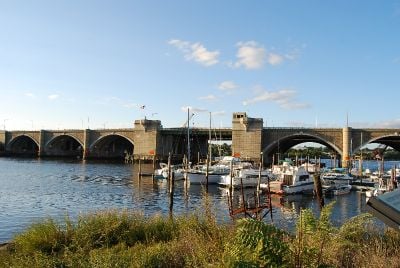
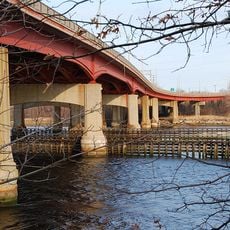
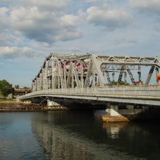
Washington Bridge, Bascule bridge over Seekonk River, Rhode Island, US

The Washington Bridge is a bascule bridge with two parallel steel structures connecting East Providence and Providence across the Seekonk River while carrying Interstate 195 and multiple routes. The structure was designed to handle substantial traffic volumes between the two communities.

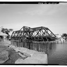
An original covered drawbridge from 1793 was the first permanent crossing between Providence and East Providence, replacing earlier unreliable ferry services. The current steel structure was built in the early 1900s and has undergone modernization since.

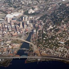
The George Redman Linear Park occupies a section of the original bridge structure and provides pedestrians and cyclists with a path along the Seekonk River. This section shows how residents use the bridge infrastructure for daily movement and recreation.

The bridge accommodates vehicle traffic on Interstate 195 as well as pedestrian and bicycle access. Plan for delays during travel, especially during peak hours, as the structure is undergoing modifications.

The 1930 bridge construction included stone monuments with bronze dedications to George Washington, embedding historical recognition directly into the infrastructure. These dedications are visible reminders of the symbolic importance assigned to the crossing when built.

The community of curious travelers

AroundUs brings together thousands of curated places, local tips, and hidden gems, enriched daily by 60,000 contributors worldwide.

Start exploring
Location
Made from material
steel
GPS coordinates
41.81910,-71.38700
Latest update
December 12, 2025 09:00
Around this place
John Brown House
United States of America

John Brown House

1.4 km
Crook Point Bascule Bridge
United States of America

Crook Point Bascule Bridge

549 m
Iway
United States of America

Iway

1.2 km
John Carter Brown Library
United States of America

John Carter Brown Library

1.6 km
India Point Park
United States of America

India Point Park

494 m
Michael S. Van Leesten Memorial Bridge
United States of America

Michael S. Van Leesten Memorial Bridge

1.5 km
Henderson Bridge
United States of America

Henderson Bridge

1.4 km
Nelson W. Aldrich House
United States of America

Nelson W. Aldrich House

1 km
Governor Stephen Hopkins House
United States of America

Governor Stephen Hopkins House

1.4 km
Sayles Memorial Hall
United States of America

Sayles Memorial Hall

1.5 km
United States of America

Wayland Square

1.2 km
Nightingale–Brown House
United States of America

Nightingale–Brown House

1.4 km
Point Street Bridge
United States of America

Point Street Bridge

1.4 km
India Point Railroad Bridge
United States of America

India Point Railroad Bridge

226 m
Governor Henry Lippitt House
United States of America

Governor Henry Lippitt House

1.3 km
United States of America

Bold Point

564 m
World War I Memorial
United States of America

World War I Memorial

1.4 km
Thomas F. Hoppin House
United States of America

Thomas F. Hoppin House

1.4 km
Corliss-Carrington House
United States of America

Corliss-Carrington House

1.3 km
Candace Allen House
United States of America

Candace Allen House

1.6 km
Thomas P. Ives House
United States of America

Thomas P. Ives House

1.4 km
Joseph Haile House
United States of America

Joseph Haile House

1.5 km
Oddfellows' Hall
United States of America

Oddfellows' Hall

463 m
Wayland Historic District
United States of America

Wayland Historic District

1.5 km
Stimson Avenue Historic District
United States of America

Stimson Avenue Historic District

1.2 km
Nathaniel Pearce House
United States of America

Nathaniel Pearce House

1.2 km
Lippitt House Museum
United States of America

Lippitt House Museum

1.3 km
Hope-Power-Cooke Streets Historic District
United States of America

Hope-Power-Cooke Streets Historic District

1.2 km
Show the full map
Reviews
Share your experience

No review yet

Discussions
Start a discussion...

No discussion yet

« Washington Bridge - Bascule bridge over Seekonk River, Rhode Island, US » is provided by Around Us (aroundus.com). Images and texts are derived from Wikimedia project under a Creative Commons license. You are allowed to copy, distribute, and modify copies of this page, under the conditions set by the license, as long as this note is clearly visible.

Discover hidden gems everywhere you go!

From secret cafés to breathtaking viewpoints, skip the crowded tourist spots and find places that match your style. Our app makes it easy with voice search, smart filtering, route optimization, and insider tips from travelers worldwide. Download now for the complete mobile experience.

Around Us App Screenshot

A unique approach to discovering new places

Le Figaro

All the places worth exploring

France Info

A tailor-made excursion in just a few clicks

20 Minutes

Around Us
Travel Guide & Maps
Download

Send to your phone

QR Code
1

Open the camera app on your mobile.

2

Point at the QR code with your camera. A notification will appear.

3

Tap the notification to open the link.