Enable Location

We need your location to show you interesting places around you

Discover nearby places

Find interesting locations and hidden gems around you

Precise directions

Get accurate directions and distances to places

Your location is never shared with other users. It's only used when you tap the location button.

Inspiration Peak

Log in to your account

Start exploring — it's free

Trusted by 65,521 travelers worldwide

Continue with Google
Continue with Apple
or

We will send you a code to connect

By continuing, you accept our Terms and Conditions and our Privacy Policy

Check your inbox

We've sent a pincode in your inbox. Please enter the code below.

Inspiration Peak
Discussion Reviews 1 Photos
5.7k Popularity

Inspiration Peak, Mountain summit in Otter Tail County, Minnesota.

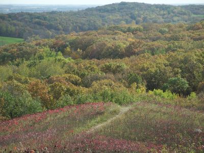
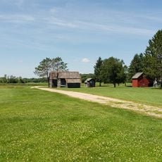
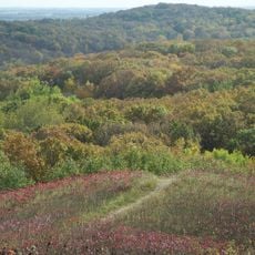
Inspiration Peak is a summit in Otter Tail County, central Minnesota, rising about 310 feet (94 m) above the surrounding plains to an elevation of roughly 1,727 feet (526 m) above sea level. The hill sits within a rolling glacial landscape and offers an open view over lakes, fields, and woodlands in every direction.

The hill was shaped during the last ice age by the Alexandria Moraine, formed by the advance of two separate ice lobes across the region. The slow retreat of that ice left behind the rolling hills and scattered lakes that still define the landscape today.

Sinclair Lewis, who grew up nearby, wrote about the view from this summit and described dozens of lakes spread across fields and pastures below. His account helped give the place its lasting name and drew wider attention to this part of Minnesota.

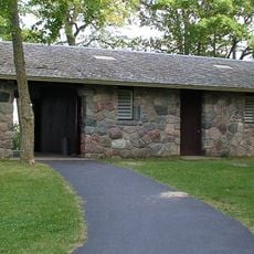
A short trail leads from the paved parking area to the top, with benches placed along the way if you want to stop and rest. The path is easy to follow and manageable for most visitors without any special preparation.

The lower slopes of the hill are covered with oak trees, while the top hosts prairie plants such as pasqueflower and blazing star that rarely grow side by side with forest species. This mix of two different plant communities on a single small hill is unusual for the region.

The community of curious travelers

AroundUs brings together thousands of curated places, local tips, and hidden gems, enriched daily by 60,000 contributors worldwide.

Start exploring
GPS coordinates
46.13624,-95.57376
Latest update
March 3, 2026 10:08
Around this place
Kensington Runestone
United States of America

Kensington Runestone

36.8 km
Glendalough State Park
United States of America

Glendalough State Park

23.1 km
Maplewood State Park
United States of America

Maplewood State Park

52.8 km
Lake Carlos State Park
United States of America

Lake Carlos State Park

24 km
Phelps Mill
United States of America

Phelps Mill

33.2 km
Church of St. Joseph-Catholic
United States of America

Church of St. Joseph-Catholic

54.8 km
Glenwood Public Library
United States of America

Glenwood Public Library

56.1 km
Finn Creek Museum
United States of America

Finn Creek Museum

40 km
Hewitt Public School
United States of America

Hewitt Public School

43.3 km
Park Region Luther College
United States of America

Park Region Luther College

42.5 km
Prospect House
United States of America

Prospect House

19.9 km
Fergus Falls City Hall
United States of America

Fergus Falls City Hall

41.9 km
Otter Tail County Courthouse
United States of America

Otter Tail County Courthouse

41.8 km
Grant County Courthouse
United States of America

Grant County Courthouse

34.8 km
River Inn
United States of America

River Inn

41.8 km
C.C. Clement House
United States of America

C.C. Clement House

41.4 km
Trinity Lutheran Church
United States of America

Trinity Lutheran Church

23 km
C.J. Wright House
United States of America

C.J. Wright House

41.2 km
Hotel Kaddatz
United States of America

Hotel Kaddatz

41.9 km
Roosevelt Hall
United States of America

Roosevelt Hall

34.9 km
Pope County Courthouse
United States of America

Pope County Courthouse

56 km
Daniel Pennie House
United States of America

Daniel Pennie House

50.5 km
District No. 182 School
United States of America

District No. 182 School

34.1 km
Craigie Flour Mill Historical Marker
United States of America

Craigie Flour Mill Historical Marker

27.1 km
Fremad Association Building
United States of America

Fremad Association Building

56 km
John W. Mason House
United States of America

John W. Mason House

41.8 km
Inspiration Peak State Wayside Park
United States of America

Inspiration Peak State Wayside Park

314 m
Lake Carlos State Park WPA/Rustic Style Historic District
United States of America

Lake Carlos State Park WPA/Rustic Style Historic District

23.7 km
Show the full map
Reviews
Share your experience

No review yet

Discussions
Start a discussion...

No discussion yet

« Inspiration Peak - Mountain summit in Otter Tail County, Minnesota » is provided by Around Us (aroundus.com). Images and texts are derived from Wikimedia project under a Creative Commons license. You are allowed to copy, distribute, and modify copies of this page, under the conditions set by the license, as long as this note is clearly visible.

Discover hidden gems everywhere you go!

From secret cafés to breathtaking viewpoints, skip the crowded tourist spots and find places that match your style. Our app makes it easy with voice search, smart filtering, route optimization, and insider tips from travelers worldwide. Download now for the complete mobile experience.

Around Us App Screenshot

A unique approach to discovering new places

Le Figaro

All the places worth exploring

France Info

A tailor-made excursion in just a few clicks

20 Minutes

Around Us
Travel Guide & Maps
Download

Send to your phone

QR Code
1

Open the camera app on your mobile.

2

Point at the QR code with your camera. A notification will appear.

3

Tap the notification to open the link.