Chest opened
+${chestReward.xp} XP
Explorer
NOUVEAU ×${chestReward.collectible.quantity}
tapez pour fermer
Chest locked

Open chests in the app

Around Us is built for your phone — chests unlock when you walk, explore and capture nearby places.

Enable Location

We need your location to show you interesting places around you

Discover nearby places

Find interesting locations and hidden gems around you

Precise directions

Get accurate directions and distances to places

Your location is never shared with other users. It's only used when you tap the location button.

Lake Bomoseen

Log in to your account

Start exploring — it's free

Trusted by 72,901 travelers worldwide

Continue with Google
Continue with Apple
or

We will send you a code to connect

By continuing, you accept our Terms and Conditions and our Privacy Policy

Check your inbox

We've sent a pincode in your inbox. Please enter the code below.

Lake Bomoseen
Discussion Reviews 1 Photos
10.3k Popularity

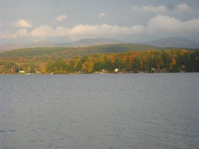
Lake Bomoseen, Recreational lake in Rutland County, Vermont, US

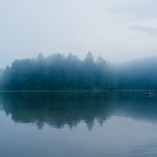
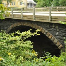
Lake Bomoseen is the largest lake located entirely within Vermont, sitting in Rutland County and surrounded by wooded hills. It drains through the Castleton River, connecting it to the broader water network of the region.

In the 1800s, slate mining shaped the land around the lake and drove much of the local economy. Abandoned quarries and piles of rock debris from that era are still visible in the landscape today.

Neshobe Island, a small island on the lake, drew writers and artists in the 1920s who used it as a private retreat. That creative chapter is still part of how locals remember and talk about the lake today.

The lake has several public access points with boat ramps, so visitors can arrive by water or on foot depending on where they enter. A state park nearby offers camping for those who want to spend more than a day here.

The lake is fed by five main inlets and drains a large watershed toward Lake Champlain to the west. This makes it one of the more important water junctions in the western Vermont drainage network.

The community of curious travelers

AroundUs brings together thousands of curated places, local tips, and hidden gems, enriched daily by 60,000 contributors worldwide.

Start exploring
Location
GPS coordinates
43.64417,-73.21306
Latest update
March 3, 2026 08:21
Around this place
Wilson Castle
United States of America

Wilson Castle

15.2 km
Vermont Marble Museum
United States of America

Vermont Marble Museum

14.5 km
Devil's Bowl Speedway
United States of America

Devil's Bowl Speedway

7 km
Castleton Medical College Building
United States of America

Castleton Medical College Building

4.7 km
Hyde's Hotel
United States of America

Hyde's Hotel

15.6 km
William Miller Chapel and Ascension Rock
United States of America

William Miller Chapel and Ascension Rock

9.7 km
Half Moon Pond State Park
United States of America

Half Moon Pond State Park

6.2 km
Gorham Covered Bridge
United States of America

Gorham Covered Bridge

14.6 km
Cooley Covered Bridge
United States of America

Cooley Covered Bridge

15.7 km
Marble Bridge
United States of America

Marble Bridge

14.6 km
Hammond Covered Bridge
United States of America

Hammond Covered Bridge

15.4 km
Fort Warren
United States of America

Fort Warren

5.1 km
South Street Bridge
United States of America

South Street Bridge

14.7 km
Depot Covered Bridge
United States of America

Depot Covered Bridge

15.5 km
West Haven Baptist Church
United States of America

West Haven Baptist Church

10.9 km
West Rutland Town Hall
United States of America

West Rutland Town Hall

14.3 km
Colburn Bridge
United States of America

Colburn Bridge

16.9 km
Home Farm
United States of America

Home Farm

15.2 km
Asahel Kidder House
United States of America

Asahel Kidder House

8.8 km
Fair Haven Green Historic District
United States of America

Fair Haven Green Historic District

7.1 km
Pittsford Green Historic District
United States of America

Pittsford Green Historic District

16.4 km
Hydeville School
United States of America

Hydeville School

4.5 km
East Poultney Historic District
United States of America

East Poultney Historic District

13.2 km
Simeon Smith House
United States of America

Simeon Smith House

7.1 km
Sudbury School No. 3
United States of America

Sudbury School No. 3

17 km
Marble Street Historic District
United States of America

Marble Street Historic District

14.2 km
Poultney Main Street Historic District
United States of America

Poultney Main Street Historic District

14.2 km
William Miller Home
United States of America

William Miller Home

9.5 km
Show the full map
Reviews
Share your experience

No review yet

Discussions
Start a discussion...

No discussion yet

« Lake Bomoseen - Recreational lake in Rutland County, Vermont, US » is provided by Around Us (aroundus.com). Images and texts are derived from Wikimedia project under a Creative Commons license. You are allowed to copy, distribute, and modify copies of this page, under the conditions set by the license, as long as this note is clearly visible.

Discover hidden gems everywhere you go!

From secret cafés to breathtaking viewpoints, skip the crowded tourist spots and find places that match your style. Our app makes it easy with voice search, smart filtering, route optimization, and insider tips from travelers worldwide. Download now for the complete mobile experience.

Around Us App Screenshot

A unique approach to discovering new places

Le Figaro

All the places worth exploring

France Info

A tailor-made excursion in just a few clicks

20 Minutes

Around Us
Travel Guide & Maps
Download

Send to your phone

QR Code
1

Open the camera app on your mobile.

2

Point at the QR code with your camera. A notification will appear.

3

Tap the notification to open the link.