Lacreek National Wildlife Refuge

Log in to your account

AroundUs is a community-driven map of interesting places, built by curious explorers like you. It grows with every review, story, and photo you share.
Connect to save your favorite spots, contribute locations, and create personalized routes.
Continue with Google
Continue with Apple
Continue with X
Continue with Facebook
Continue with email
By continuing, you accept our Terms and Conditions and our Privacy Policy
Create an account

Lacreek National Wildlife Refuge

Add to collection
Map
Suggest a change
Share

Lacreek National Wildlife Refuge, National Wildlife Refuge in Bennett County, South Dakota.

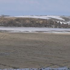
Lacreek National Wildlife Refuge is a protected area covering 16,570 acres of wetlands, meadows, and planted forests along the northern edge of the Nebraska Sandhills. These varied habitats support a wide range of birds and other wildlife throughout the year.

The refuge was established on August 26, 1935, following conservation work by the Civilian Conservation Corps during the Great Depression. This initiative helped protect vital wildlife habitat in the region during a critical period.

The area served as a gathering place for Native American tribes including the Lakota, Cheyenne, Arapaho, and Pawnee during the 1800s. This heritage remains woven into how people today understand and respect the landscape.

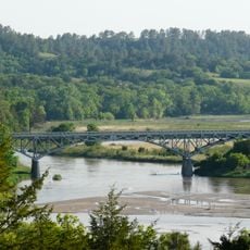
The refuge can be explored by driving auto routes, accessing waterways by boat, or walking designated trails like the Pelican Island Trail and Bird Trail. Using a car works best for covering longer distances, while walking trails offer closer views of specific habitats.

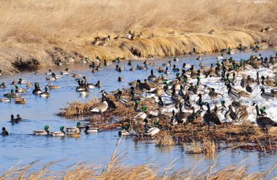
The refuge provides winter shelter for 80 to 100 trumpeter swans, a species that makes this place a key stopping point in their annual cycle. During migration and rest periods, tens of thousands of ducks and geese arrive here, creating remarkable viewing opportunities for bird watchers.

Location: South Dakota

Inception: August 26, 1935

Website: https://fws.gov/refuge/lacreek

GPS coordinates: 43.09890,-101.58600

Latest update: December 13, 2025 17:04

Photos
Around this place
Minuteman Missile National Historic Site
United States of America

Minuteman Missile National Historic Site

103.6 km
Wounded Knee National Historic Landmark
United States of America

Wounded Knee National Historic Landmark

63.5 km
United States of America

Spade Ranch

97.5 km
Fort Niobrara National Wildlife Refuge
United States of America

Fort Niobrara National Wildlife Refuge

95.9 km
St. Francis Mission
United States of America

St. Francis Mission

56.9 km
Camp Sheridan
United States of America

Camp Sheridan

98.3 km
Prairie Homestead
United States of America

Prairie Homestead

82.3 km
Bryan Bridge
United States of America

Bryan Bridge

91.2 km
Cherry County Courthouse
United States of America

Cherry County Courthouse

87.9 km
Valentine Public School
United States of America

Valentine Public School

88.2 km
Adamson Bridge
United States of America

Adamson Bridge

81.2 km
Borman Bridge
United States of America

Borman Bridge

91 km
Berry State Aid Bridge
United States of America

Berry State Aid Bridge

102 km
Plains Theatre
United States of America

Plains Theatre

83 km
Inland Theater
United States of America

Inland Theater

14.8 km
Mt. Moriah Masonic Lodge No. 155
United States of America

Mt. Moriah Masonic Lodge No. 155

82.3 km
Sheridan County Courthouse
United States of America

Sheridan County Courthouse

82.9 km
F.M. Walcott House
United States of America

F.M. Walcott House

87.6 km
Spotted Tail Gravesite
United States of America

Spotted Tail Gravesite

61.6 km
Lee and Gottliebe Fritz House
United States of America

Lee and Gottliebe Fritz House

60.1 km
Wounded Knee cemetery
United States of America

Wounded Knee cemetery

63.5 km
Distrito electoral de Valentine (condado de Cherry, Nebraska)
United States of America

Distrito electoral de Valentine (condado de Cherry, Nebraska)

90.2 km
Ben Reifel Visitor Center
United States of America

Ben Reifel Visitor Center

77.9 km
Cedar Pass Campground
United States of America

Cedar Pass Campground

77.6 km
Minuteman Missile National Historic Site Visitor Center
United States of America

Minuteman Missile National Historic Site Visitor Center

86.8 km
Ancient Hunters Overlook
United States of America

Ancient Hunters Overlook

99.9 km
Yellow Mounds Overlook
United States of America

Yellow Mounds Overlook

96.4 km
Saddle Pass Trailhead
United States of America

Saddle Pass Trailhead

79.8 km
Show the full map
Reviews

Visited this place? Tap the stars to rate it and share your experience / photos with the community! Try now! You can cancel it anytime.

« Lacreek National Wildlife Refuge - National Wildlife Refuge in Bennett County, South Dakota » is provided by Around Us (aroundus.com). Images and texts are derived from Wikimedia project under a Creative Commons license. You are allowed to copy, distribute, and modify copies of this page, under the conditions set by the license, as long as this note is clearly visible.

Discover hidden gems everywhere you go!

From secret cafés to breathtaking viewpoints, skip the crowded tourist spots and find places that match your style. Our app makes it easy with voice search, smart filtering, route optimization, and insider tips from travelers worldwide. Download now for the complete mobile experience.

Around Us App Screenshot

A unique approach to discovering new places

Le Figaro

All the places worth exploring

France Info

A tailor-made excursion in just a few clicks

20 Minutes