Enable Location

We need your location to show you interesting places around you

Discover nearby places

Find interesting locations and hidden gems around you

Precise directions

Get accurate directions and distances to places

Your location is never shared with other users. It's only used when you tap the location button.

Lechmere Viaduct

Log in to your account

Start exploring — it's free

Trusted by 62,521 travelers worldwide

Continue with Google
Continue with Apple
or

We will send you a code to connect

By continuing, you accept our Terms and Conditions and our Privacy Policy

Check your inbox

We've sent a pincode in your inbox. Please enter the code below.

Lechmere Viaduct

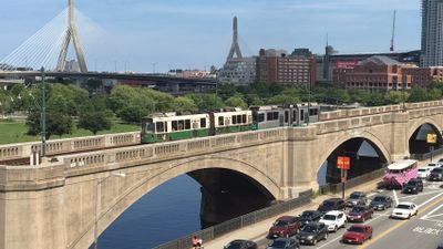
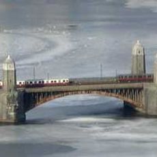
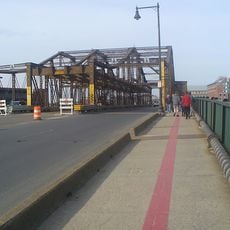
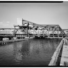
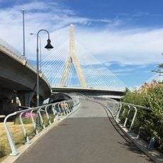
Lechmere Viaduct, Arch bridge across Charles River in Boston, United States.

The Lechmere Viaduct is an arch bridge spanning the Charles River with ten concrete arch sections, connecting Boston's West End to East Cambridge. The structure stretches approximately 1,700 feet and today carries Green Line streetcar traffic.

The Pennsylvania Steel Company and the architectural firm Holbrook, Cabot and Rollins built the structure, which opened to streetcar service in 1912. It became an important part of Boston's growing public transportation network in the early 1900s.

The viaduct carries thousands of Green Line passengers daily and forms a key connection between Cambridge and downtown Boston in the city's public transit network. It shapes how people move between these neighborhoods and defines the area's transportation landscape.

The viaduct is accessible to pedestrians and offers views of the Charles River, especially when walking alongside or crossing it with the Green Line. The structure is best appreciated during daylight hours when you can see the arch details and span clearly.

The bridge contains a rare movable bascule mechanism that allows certain sections to pivot upward, enabling boats to pass underneath. This mechanical system is rarely used today but remains an intriguing reminder of how earlier transportation planners needed to balance rail, pedestrian, and water traffic.

The community of curious travelers

AroundUs brings together thousands of curated places, local tips, and hidden gems, enriched daily by 60,000 contributors worldwide.

Start exploring
Location
Official opening
June 1, 1912
Part of
Green Line
GPS coordinates
42.36803,-71.07035
Latest update
December 10, 2025 16:27
Around this place
TD Garden
United States of America

TD Garden

695 m
Leonard P. Zakim Bunker Hill Memorial Bridge
United States of America

Leonard P. Zakim Bunker Hill Memorial Bridge

594 m
Longfellow Bridge
United States of America

Longfellow Bridge

816 m
Ether Dome
United States of America

Ether Dome

541 m
Charlestown Bridge
United States of America

Charlestown Bridge

857 m
Avalon North Station
United States of America

Avalon North Station

611 m
Charlestown High Bridge
United States of America

Charlestown High Bridge

657 m
Statue of Bobby Orr
United States of America

Statue of Bobby Orr

852 m
Leverett Circle Connector Bridge
United States of America

Leverett Circle Connector Bridge

488 m
Thomas P. O'Neill Jr. Federal Building
United States of America

Thomas P. O'Neill Jr. Federal Building

674 m
Luna
United States of America

Luna

315 m
Massachusetts General Hospital, Bulfinch Building
United States of America

Massachusetts General Hospital, Bulfinch Building

536 m
Frances Appleton Bridge
United States of America

Frances Appleton Bridge

844 m
North Point Park
United States of America

North Point Park

160 m
Charles River Bridge
United States of America

Charles River Bridge

429 m
Middlesex County Courthouse
United States of America

Middlesex County Courthouse

797 m
CitizenM Boston North Station
United States of America

CitizenM Boston North Station

739 m
World War II Memorial
United States of America

World War II Memorial

766 m
West End Museum
United States of America

West End Museum

684 m
North Bank Bridge
United States of America

North Bank Bridge

420 m
Government Service Center
United States of America

Government Service Center

863 m
Town Hill District
United States of America

Town Hill District

834 m
Building at 42 Edward J. Lopez Avenue
United States of America

Building at 42 Edward J. Lopez Avenue

794 m
Lily P's Fried Chicken and Oysters
United States of America

Lily P's Fried Chicken and Oysters

758 m
Massachusetts General Hospital
United States of America

Massachusetts General Hospital

590 m
Multicultural Arts Center
United States of America

Multicultural Arts Center

741 m
Otis House Museum
United States of America

Otis House Museum

864 m
James B. Barnes House
United States of America

James B. Barnes House

866 m
Show the full map
« Lechmere Viaduct - Arch bridge across Charles River in Boston, United States » is provided by Around Us (aroundus.com). Images and texts are derived from Wikimedia project under a Creative Commons license. You are allowed to copy, distribute, and modify copies of this page, under the conditions set by the license, as long as this note is clearly visible.

Discover hidden gems everywhere you go!

From secret cafés to breathtaking viewpoints, skip the crowded tourist spots and find places that match your style. Our app makes it easy with voice search, smart filtering, route optimization, and insider tips from travelers worldwide. Download now for the complete mobile experience.

Around Us App Screenshot

A unique approach to discovering new places

Le Figaro

All the places worth exploring

France Info

A tailor-made excursion in just a few clicks

20 Minutes

Around Us
Travel Guide & Maps
Download

Send to your phone

QR Code
1

Open the camera app on your mobile.

2

Point at the QR code with your camera. A notification will appear.

3

Tap the notification to open the link.