Enable Location

We need your location to show you interesting places around you

Discover nearby places

Find interesting locations and hidden gems around you

Precise directions

Get accurate directions and distances to places

Your location is never shared with other users. It's only used when you tap the location button.

Charlestown High Bridge

Log in to your account

Start exploring — it's free

Trusted by 62,942 travelers worldwide

Continue with Google
Continue with Apple
or

We will send you a code to connect

By continuing, you accept our Terms and Conditions and our Privacy Policy

Check your inbox

We've sent a pincode in your inbox. Please enter the code below.

Charlestown High Bridge
Discussion Reviews 1 Photos
6.1k Popularity

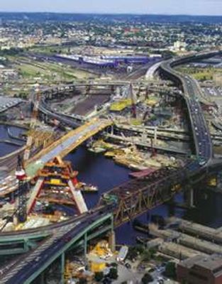
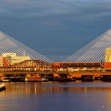
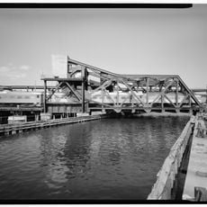
Charlestown High Bridge, Highway bridge in Boston, United States

Charlestown High Bridge crosses the Charles River with a double-deck Warren truss structure, connecting downtown Boston to the Charlestown neighborhood. It carries traffic from Interstate 93 and US Route 1 in both directions.

The bridge opened in 1954 as a major infrastructure project that modernized Boston's highway system. It replaced earlier river crossings that served the area since colonial times.

This crossing symbolizes mid-20th century decisions to expand car infrastructure through the city center. It shaped how people move between downtown and the neighborhood across the river.

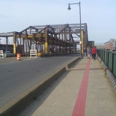
The bridge is designed for vehicle traffic only and not accessible to pedestrians or bicycles. Visitors can view the structure from nearby shore areas or from overlooks at either end.

The bridge features an unusual northbound configuration where traffic lanes merge to accommodate Storrow Drive connections. This distinctive design choice created predictable congestion patterns that became a defining feature of Boston traffic.

The community of curious travelers

AroundUs brings together thousands of curated places, local tips, and hidden gems, enriched daily by 60,000 contributors worldwide.

Start exploring
Location
Inception
1954
Official opening
1954
GPS coordinates
42.36910,-71.06250
Latest update
December 9, 2025 18:45
Around this place
USS Constitution
United States of America

USS Constitution

658 m
TD Garden
United States of America

TD Garden

312 m
Old North Church
United States of America

Old North Church

728 m
Leonard P. Zakim Bunker Hill Memorial Bridge
United States of America

Leonard P. Zakim Bunker Hill Memorial Bridge

69 m
Skinny House
United States of America

Skinny House

573 m
USS Cassin Young
United States of America

USS Cassin Young

748 m
Copp's Hill Burying Ground
United States of America

Copp's Hill Burying Ground

544 m
Charlestown Bridge
United States of America

Charlestown Bridge

207 m
Avalon North Station
United States of America

Avalon North Station

364 m
Statue of Bobby Orr
United States of America

Statue of Bobby Orr

373 m
Lechmere Viaduct
United States of America

Lechmere Viaduct

657 m
Leverett Circle Connector Bridge
United States of America

Leverett Circle Connector Bridge

173 m
Thomas P. O'Neill Jr. Federal Building
United States of America

Thomas P. O'Neill Jr. Federal Building

437 m
Bulfinch Triangle Historic District
United States of America

Bulfinch Triangle Historic District

587 m
Charles River Bridge
United States of America

Charles River Bridge

231 m
St. Mary – St. Catherine of Siena Parish
United States of America

St. Mary – St. Catherine of Siena Parish

516 m
Charlestown Civil War Memorial
United States of America

Charlestown Civil War Memorial

629 m
CitizenM Boston North Station
United States of America

CitizenM Boston North Station

413 m
World War II Memorial
United States of America

World War II Memorial

268 m
West End Museum
United States of America

West End Museum

547 m
North Terminal Garage
United States of America

North Terminal Garage

457 m
North Bank Bridge
United States of America

North Bank Bridge

269 m
Government Service Center
United States of America

Government Service Center

736 m
Ozias Goodwin House
United States of America

Ozias Goodwin House

636 m
Town Hill District
United States of America

Town Hill District

409 m
Charlestown Five Cent Savings Bank
United States of America

Charlestown Five Cent Savings Bank

707 m
The Battle of Bunker Hill Museum
United States of America

The Battle of Bunker Hill Museum

728 m
Hoosac Stores
United States of America

Hoosac Stores

540 m
Show the full map
Reviews
Share your experience

No review yet

Discussions
Start a discussion...

No discussion yet

« Charlestown High Bridge - Highway bridge in Boston, United States » is provided by Around Us (aroundus.com). Images and texts are derived from Wikimedia project under a Creative Commons license. You are allowed to copy, distribute, and modify copies of this page, under the conditions set by the license, as long as this note is clearly visible.

Discover hidden gems everywhere you go!

From secret cafés to breathtaking viewpoints, skip the crowded tourist spots and find places that match your style. Our app makes it easy with voice search, smart filtering, route optimization, and insider tips from travelers worldwide. Download now for the complete mobile experience.

Around Us App Screenshot

A unique approach to discovering new places

Le Figaro

All the places worth exploring

France Info

A tailor-made excursion in just a few clicks

20 Minutes

Around Us
Travel Guide & Maps
Download

Send to your phone

QR Code
1

Open the camera app on your mobile.

2

Point at the QR code with your camera. A notification will appear.

3

Tap the notification to open the link.