Enable Location

We need your location to show you interesting places around you

Discover nearby places

Find interesting locations and hidden gems around you

Precise directions

Get accurate directions and distances to places

Your location is never shared with other users. It's only used when you tap the location button.

Copp's Hill Burying Ground

Log in to your account

Start exploring — it's free

Trusted by 61,457 travelers worldwide

Continue with Google
Continue with Apple
or

We will send you a code to connect

By continuing, you accept our Terms and Conditions and our Privacy Policy

Check your inbox

We've sent a pincode in your inbox. Please enter the code below.

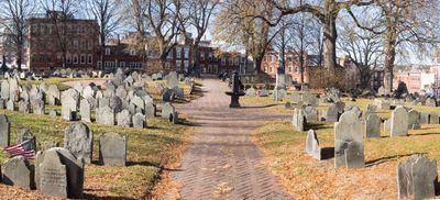
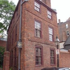
Copp's Hill Burying Ground, Colonial cemetery in North End, Boston, US.

Description

Copp's Hill Burying Ground is a cemetery on a hillside in Boston's North End, stretching along Hull Street and Snowhill Road. The graves sit on steep and level sections, with many headstones carved from slate or granite showing faded inscriptions and winged skulls.

History

The cemetery was established in 1659 as the city's second burial ground and served British troops as an artillery position during the Revolution. Cannonballs flew from this hilltop toward Charlestown during the Battle of Bunker Hill in June 1775.

Culture

The cemetery takes its name from William Copp, a cobbler and early settler whose family owned land on the hilltop. Visitors notice the divided history of the grounds, where wealthy merchants rest alongside free Black residents who witnessed the end of slavery in Massachusetts.

Practical

The main entrance is at 45 Hull Street and opens daily from 9 AM to 4 PM, with free access for visitors. Paths are uneven and climb steeply in places, so sturdy footwear helps when walking the grounds.

Did you know?

Captain Daniel Malcolm's headstone bears bullet holes from British soldiers who used the monuments as shooting targets during their occupation. His grave was chosen deliberately, as Malcolm was known during his lifetime as a smuggler and rebel against the Crown.

Location
Inception
1659
Part of
Freedom Trail
GPS coordinates
42.36722,-71.05639
Latest update
December 5, 2025 22:29

AroundUs brings together thousands of curated places, local tips, and hidden gems, enriched daily by 60,000 contributors worldwide. Discover all places nearby (Boston).

Around this place
USS Constitution
United States of America

USS Constitution

547 m
TD Garden
United States of America

TD Garden

491 m
Old North Church
United States of America

Old North Church

185 m
Leonard P. Zakim Bunker Hill Memorial Bridge
United States of America

Leonard P. Zakim Bunker Hill Memorial Bridge

585 m
Paul Revere House
United States of America

Paul Revere House

449 m
Skinny House
United States of America

Skinny House

39 m
USS Cassin Young
United States of America

USS Cassin Young

579 m
Equestrian statue of Paul Revere
United States of America

Equestrian statue of Paul Revere

316 m
Charlestown Bridge
United States of America

Charlestown Bridge

351 m
Avalon North Station
United States of America

Avalon North Station

602 m
Charlestown High Bridge
United States of America

Charlestown High Bridge

544 m
Statue of Bobby Orr
United States of America

Statue of Bobby Orr

343 m
Thomas P. O'Neill Jr. Federal Building
United States of America

Thomas P. O'Neill Jr. Federal Building

596 m
North Square
United States of America

North Square

474 m
North Street, Boston
United States of America

North Street, Boston

507 m
Bulfinch Triangle Historic District
United States of America

Bulfinch Triangle Historic District

554 m
Paul Revere Mall
United States of America

Paul Revere Mall

268 m
Statue of Tony DeMarco
United States of America

Statue of Tony DeMarco

530 m
Pierce-Hichborn House
United States of America

Pierce-Hichborn House

464 m
United States of America

Old North Memorial Garden

211 m
CitizenM Boston North Station
United States of America

CitizenM Boston North Station

512 m
North Terminal Garage
United States of America

North Terminal Garage

118 m
Fulton-Commercial Streets District
United States of America

Fulton-Commercial Streets District

639 m
Ozias Goodwin House
United States of America

Ozias Goodwin House

126 m
Traffic Tunnel Administration Building
United States of America

Traffic Tunnel Administration Building

544 m
Civic Service House
United States of America

Civic Service House

297 m
North End Branch Library
United States of America

North End Branch Library

369 m
Hoosac Stores
United States of America

Hoosac Stores

603 m
Show the full map
« Copp's Hill Burying Ground - Colonial cemetery in North End, Boston, US » is provided by Around Us (aroundus.com). Images and texts are derived from Wikimedia project under a Creative Commons license. You are allowed to copy, distribute, and modify copies of this page, under the conditions set by the license, as long as this note is clearly visible.

Discover hidden gems everywhere you go!

From secret cafés to breathtaking viewpoints, skip the crowded tourist spots and find places that match your style. Our app makes it easy with voice search, smart filtering, route optimization, and insider tips from travelers worldwide. Download now for the complete mobile experience.

Around Us App Screenshot

A unique approach to discovering new places

Le Figaro

All the places worth exploring

France Info

A tailor-made excursion in just a few clicks

20 Minutes

Around Us
Travel Guide & Maps
Download

Send to your phone

QR Code
1

Open the camera app on your mobile.

2

Point at the QR code with your camera. A notification will appear.

3

Tap the notification to open the link.