Enable Location

We need your location to show you interesting places around you

Discover nearby places

Find interesting locations and hidden gems around you

Precise directions

Get accurate directions and distances to places

Your location is never shared with other users. It's only used when you tap the location button.

Fulton-Commercial Streets District

Log in to your account

Start exploring — it's free

Trusted by 62,521 travelers worldwide

Continue with Google
Continue with Apple
or

We will send you a code to connect

By continuing, you accept our Terms and Conditions and our Privacy Policy

Check your inbox

We've sent a pincode in your inbox. Please enter the code below.

Fulton-Commercial Streets District, historic district in Massachusetts, United States

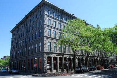
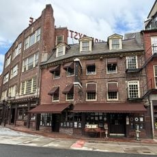
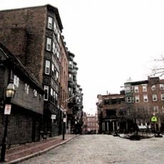
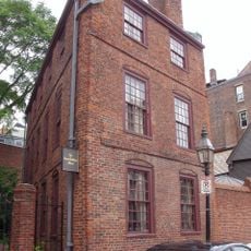
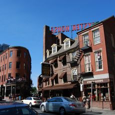
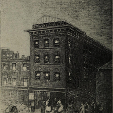
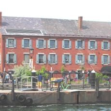
The Fulton-Commercial Streets District is a historic neighborhood in Boston's North End featuring narrow streets lined with Renaissance Revival brick buildings dating from the late 1800s and early 1900s. The area contains a mix of shops, cafes, and residences closely clustered together, creating an active street environment with varied storefronts and architectural details.

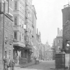
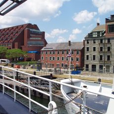
The district was built in the 1800s on landfill near Boston Harbor as part of the city's expansion, reflecting its important role during the shipping and trading era. It received National Register listing in 1973 and saw boundary expansion in 2000 to include additional historic properties.

The streets reflect Italian heritage through restaurants, bakeries, and summer festivals that celebrate local traditions with music and processions honoring saints. Residents maintain these customs while welcoming visitors to experience how community memory shapes daily life here.

Walking is the best way to explore since narrow streets are not suited for vehicles and offer a connected neighborhood feel. Plan time to wander through small shops and cafes at a relaxed pace, and expect busier conditions on weekends and during summer festivals.

The neighborhood was literally created by landfill operations that reshaped Boston's shoreline, demonstrating how the city expanded by extending its coastline into the harbor. This land reclamation made the area prime for trade and commerce during the maritime era.

The community of curious travelers

AroundUs brings together thousands of curated places, local tips, and hidden gems, enriched daily by 60,000 contributors worldwide.

Start exploring
Location
GPS coordinates
42.36194,-71.05333
Latest update
February 9, 2026 11:07
Around this place
Freedom Trail
United States of America

Freedom Trail

358 m
Faneuil Hall
United States of America

Faneuil Hall

328 m
Quincy Market
United States of America

Quincy Market

256 m
Paul Revere House
United States of America

Paul Revere House

200 m
Union Oyster House
United States of America

Union Oyster House

300 m
Custom House Tower
United States of America

Custom House Tower

320 m
New England Holocaust Memorial
United States of America

New England Holocaust Memorial

334 m
Boston National Historical Park
United States of America

Boston National Historical Park

332 m
Equestrian statue of Paul Revere
United States of America

Equestrian statue of Paul Revere

405 m
75 State Street
United States of America

75 State Street

410 m
Bunch-of-Grapes
United States of America

Bunch-of-Grapes

390 m
Statue of Christopher Columbus
United States of America

Statue of Christopher Columbus

191 m
North Square
United States of America

North Square

175 m
North Street, Boston
United States of America

North Street, Boston

134 m
Statue of Red Auerbach
United States of America

Statue of Red Auerbach

228 m
Statue of Tony DeMarco
United States of America

Statue of Tony DeMarco

193 m
Pierce-Hichborn House
United States of America

Pierce-Hichborn House

180 m
A Once and Future Shoreline
United States of America

A Once and Future Shoreline

323 m
Blackstone Block Historic District
United States of America

Blackstone Block Historic District

311 m
Custom House Block
United States of America

Custom House Block

376 m
Chart House
United States of America

Chart House

372 m
State Street Block
United States of America

State Street Block

296 m
Traffic Tunnel Administration Building
United States of America

Traffic Tunnel Administration Building

128 m
Civic Service House
United States of America

Civic Service House

354 m
Long Wharf and Customhouse Block
United States of America

Long Wharf and Customhouse Block

350 m
The Great Hall
United States of America

The Great Hall

305 m
Simons IMAX Theatre at the New England Aquarium
United States of America

Simons IMAX Theatre at the New England Aquarium

398 m
North End Branch Library
United States of America

North End Branch Library

272 m
Show the full map
« Fulton-Commercial Streets District - historic district in Massachusetts, United States » is provided by Around Us (aroundus.com). Images and texts are derived from Wikimedia project under a Creative Commons license. You are allowed to copy, distribute, and modify copies of this page, under the conditions set by the license, as long as this note is clearly visible.

Discover hidden gems everywhere you go!

From secret cafés to breathtaking viewpoints, skip the crowded tourist spots and find places that match your style. Our app makes it easy with voice search, smart filtering, route optimization, and insider tips from travelers worldwide. Download now for the complete mobile experience.

Around Us App Screenshot

A unique approach to discovering new places

Le Figaro

All the places worth exploring

France Info

A tailor-made excursion in just a few clicks

20 Minutes

Around Us
Travel Guide & Maps
Download

Send to your phone

QR Code
1

Open the camera app on your mobile.

2

Point at the QR code with your camera. A notification will appear.

3

Tap the notification to open the link.