Leominster State Forest

Log in to your account

AroundUs is a community-driven map of interesting places, built by curious explorers like you. It grows with every review, story, and photo you share.
Connect to save your favorite spots, contribute locations, and create personalized routes.
Continue with Google
Continue with Apple
Continue with X
Continue with Facebook
Continue with email
By continuing, you accept our Terms and Conditions and our Privacy Policy
Create an account
Add to collection
Map
Suggest a change
Share

Leominster State Forest, Nature reserve and state forest in Westminster, Massachusetts, US.

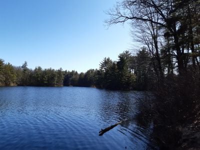
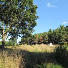
Leominster State Forest is a nature reserve spread across multiple Massachusetts towns, covering several thousand acres of woodland. The forest contains numerous ponds throughout its expanse, a network of trails for different activities, and elevated terrain that shapes the landscape.

The forest area once contained small settlements, notably Notown, which developed in the early 1700s as an unincorporated community. This settlement was absorbed into the surrounding towns during the early 1800s, leaving traces of its former existence in the landscape.

The Crow Hill ledges held significance for Native American groups who used them as shelter and vantage points for communication across the landscape. This heritage remains woven into how locals understand and interact with the forest today.

The forest remains accessible year-round with trails suitable for different abilities and interests, from casual walks to more challenging routes. Water bodies scattered throughout allow for swimming during warmer months, while winter conditions create opportunities for snow activities.

A long-distance hiking route passes through the forest, serving as a connection point between this forest and other protected lands across the state. The path attracts hikers undertaking multi-day journeys through Massachusetts.

Location: Massachusetts

Inception: 1922

Operator: DCR - Division Of State Parks And Recreation

Address: Leominster State Forest, Leominster, MA 01420, USA

Website: https://mass.gov/locations/leominster-state-forest

GPS coordinates: 42.52092,-71.83841

Latest update: December 11, 2025 11:07

Photos
Around this place
Mount Wachusett
United States of America

Mount Wachusett

5.3 km
United States of America

North County

5.3 km
Wachusett Mountain State Reservation
United States of America

Wachusett Mountain State Reservation

5.3 km
United States of America

High Ledges Wildlife Sanctuary

8.8 km
Wachusett Meadow Wildlife Sanctuary
United States of America

Wachusett Meadow Wildlife Sanctuary

9.1 km
Fay Club
United States of America

Fay Club

7.5 km
Doyle Community Park & Center
United States of America

Doyle Community Park & Center

6.1 km
Fitchburg Art Museum
United States of America

Fitchburg Art Museum

7.9 km
Doyle Community Park & Center
United States of America

Doyle Community Park & Center

6.1 km
Frances H. and Jonathan Drake House
United States of America

Frances H. and Jonathan Drake House

6.3 km
Faith United Parish
United States of America

Faith United Parish

7.7 km
Billerica Town Common District
United States of America

Billerica Town Common District

6.9 km
Monument Square Historic District
United States of America

Monument Square Historic District

6.4 km
5th street bridge
United States of America

5th street bridge

7.4 km
F. A. Whitney Carriage Company Complex Historic District
United States of America

F. A. Whitney Carriage Company Complex Historic District

6.9 km
Whitney & Company
United States of America

Whitney & Company

7 km
Russell Corner Historic District
United States of America

Russell Corner Historic District

7.9 km
Westminster Village-Academy Hill Historic District
United States of America

Westminster Village-Academy Hill Historic District

6.5 km
East Princeton Village Historic District
United States of America

East Princeton Village Historic District

5.3 km
Fitchburg Yarn Mill
United States of America

Fitchburg Yarn Mill

7.7 km
United States of America

Leominster High School

5.6 km
Fernside-Vacation House for Working Girls
United States of America

Fernside-Vacation House for Working Girls

7 km
Princeton Center Historic District
United States of America

Princeton Center Historic District

8.6 km
Ahijah Wood House
United States of America

Ahijah Wood House

4.5 km
Monument Park Historic District
United States of America

Monument Park Historic District

7.6 km
Ezra Wood-Levi Warner Place
United States of America

Ezra Wood-Levi Warner Place

5 km
Moran Square Historic District
United States of America

Moran Square Historic District

7.8 km
Nathan Wood House
United States of America

Nathan Wood House

4.4 km
Show the full map
Reviews

Visited this place? Tap the stars to rate it and share your experience / photos with the community! Try now! You can cancel it anytime.

« Leominster State Forest - Nature reserve and state forest in Westminster, Massachusetts, US » is provided by Around Us (aroundus.com). Images and texts are derived from Wikimedia project under a Creative Commons license. You are allowed to copy, distribute, and modify copies of this page, under the conditions set by the license, as long as this note is clearly visible.

Discover hidden gems everywhere you go!

From secret cafés to breathtaking viewpoints, skip the crowded tourist spots and find places that match your style. Our app makes it easy with voice search, smart filtering, route optimization, and insider tips from travelers worldwide. Download now for the complete mobile experience.

Around Us App Screenshot

A unique approach to discovering new places

Le Figaro

All the places worth exploring

France Info

A tailor-made excursion in just a few clicks

20 Minutes