Enable Location

We need your location to show you interesting places around you

Discover nearby places

Find interesting locations and hidden gems around you

Precise directions

Get accurate directions and distances to places

Your location is never shared with other users. It's only used when you tap the location button.

Bala Cynwyd Junior High School Complex

Log in to your account

Start exploring — it's free

Trusted by 62,374 travelers worldwide

Continue with Google
Continue with Apple
or

We will send you a code to connect

By continuing, you accept our Terms and Conditions and our Privacy Policy

Check your inbox

We've sent a pincode in your inbox. Please enter the code below.

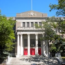
Bala Cynwyd Junior High School Complex, primary school in Pennsylvania, United States of America

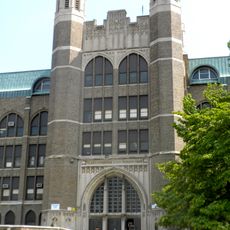
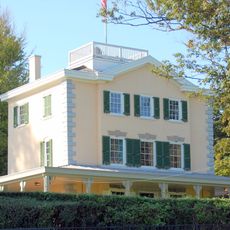
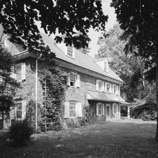
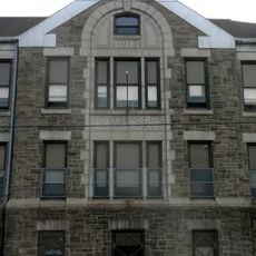
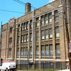
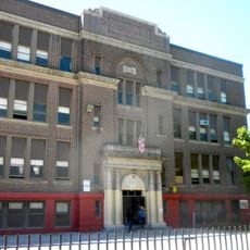
The Bala Cynwyd Junior High School Complex is a historic school building in Pennsylvania consisting of several structures built between the early 1800s and 1938. The campus features brick buildings with classical architecture, sports facilities, and open grounds covering about 16 acres.

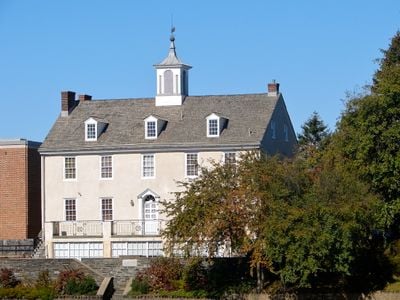
The oldest building in the complex, the Lower Merion Academy, dates to 1812 and reflects early American Federal style architecture. The main school building was completed in 1939 and evolved over decades, with significant expansions in 1963 and a major renovation in 1999.

The school's name comes from Welsh origins, with Bala and Cynwyd referencing the area's heritage and a historical family. For generations of local residents, this building was where children learned and the community came together for school events and gatherings.

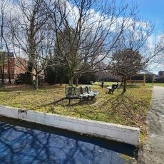
The site is best explored on foot, offering a quiet setting to walk through the historic grounds with open views of the buildings and landscaping. Visitors can appreciate the exterior architecture, brick walls, and spacious grounds at their own pace without needing interior access.

A bronze bell cast in Baltimore in 1888 once rang across the grounds to call students to class and was restored and rededicated in the 1970s. This artifact represents the daily rhythm of school life from another era and shows how objects preserve a place's past.

The community of curious travelers

AroundUs brings together thousands of curated places, local tips, and hidden gems, enriched daily by 60,000 contributors worldwide.

Start exploring
Location
GPS coordinates
40.01330,-75.24280
Latest update
February 7, 2026 11:40
Around this place
Overbrook High School
United States of America

Overbrook High School

3.6 km
Mann Center for the Performing Arts
United States of America

Mann Center for the Performing Arts

3.8 km
West Laurel Hill Cemetery
United States of America

West Laurel Hill Cemetery

1.7 km
Belmont Mansion
United States of America

Belmont Mansion

3.6 km
Manayunk Bridge
United States of America

Manayunk Bridge

1.9 km
Woodside Amusement Park
United States of America

Woodside Amusement Park

3.1 km
Temple Adath Israel of the Main Line
United States of America

Temple Adath Israel of the Main Line

1.4 km
Wynnestay
United States of America

Wynnestay

2.4 km
Arboretum of the Barnes Foundation
United States of America

Arboretum of the Barnes Foundation

1.7 km
Dimner Beeber Middle School
United States of America

Dimner Beeber Middle School

3 km
Ridgeland Mansion
United States of America

Ridgeland Mansion

3.6 km
Pencoyd Bridge
United States of America

Pencoyd Bridge

2.5 km
Overbrook Elementary School
United States of America

Overbrook Elementary School

3.5 km
Narbrook Park Historic District
United States of America

Narbrook Park Historic District

2.1 km
St. Josaphat Roman Catholic Church in Philadelphia
United States of America

St. Josaphat Roman Catholic Church in Philadelphia

2.3 km
City Line Avenue Bridge
United States of America

City Line Avenue Bridge

3.4 km
Green Lane Bridge
United States of America

Green Lane Bridge

1.9 km
Ridge Avenue Bridge in Philadelphia
United States of America

Ridge Avenue Bridge in Philadelphia

3 km
City Avenue Bridges
United States of America

City Avenue Bridges

3.1 km
Belmont Avenue Bridge in Philadelphia
United States of America

Belmont Avenue Bridge in Philadelphia

3.1 km
Monte Vista
United States of America

Monte Vista

3.8 km
Church of St. Alban, Roxborough
United States of America

Church of St. Alban, Roxborough

3.8 km
Mule Bridge
United States of America

Mule Bridge

2.2 km
House of Prayer Episcopal Church, Philadelphia
United States of America

House of Prayer Episcopal Church, Philadelphia

2.6 km
Merion Botanical Park
United States of America

Merion Botanical Park

2.2 km
James Dobson Elementary School
United States of America

James Dobson Elementary School

2.2 km
Fountain Street Steps
United States of America

Fountain Street Steps

2.2 km
Mastery Charter School Mann Elementary
United States of America

Mastery Charter School Mann Elementary

3.3 km
Show the full map
« Bala Cynwyd Junior High School Complex - primary school in Pennsylvania, United States of America » is provided by Around Us (aroundus.com). Images and texts are derived from Wikimedia project under a Creative Commons license. You are allowed to copy, distribute, and modify copies of this page, under the conditions set by the license, as long as this note is clearly visible.

Discover hidden gems everywhere you go!

From secret cafés to breathtaking viewpoints, skip the crowded tourist spots and find places that match your style. Our app makes it easy with voice search, smart filtering, route optimization, and insider tips from travelers worldwide. Download now for the complete mobile experience.

Around Us App Screenshot

A unique approach to discovering new places

Le Figaro

All the places worth exploring

France Info

A tailor-made excursion in just a few clicks

20 Minutes

Around Us
Travel Guide & Maps
Download

Send to your phone

QR Code
1

Open the camera app on your mobile.

2

Point at the QR code with your camera. A notification will appear.

3

Tap the notification to open the link.