Enable Location

We need your location to show you interesting places around you

Discover nearby places

Find interesting locations and hidden gems around you

Precise directions

Get accurate directions and distances to places

Your location is never shared with other users. It's only used when you tap the location button.

Nayatt Point Light

Log in to your account

Start exploring — it's free

Trusted by 62,908 travelers worldwide

Continue with Google
Continue with Apple
or

We will send you a code to connect

By continuing, you accept our Terms and Conditions and our Privacy Policy

Check your inbox

We've sent a pincode in your inbox. Please enter the code below.

Discussion Reviews 1 Photos
1.8k Popularity

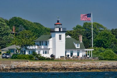
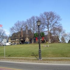
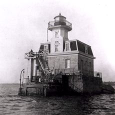
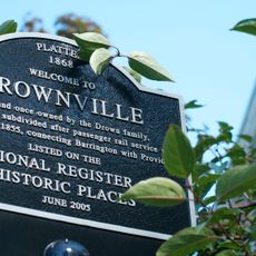
Nayatt Point Light, Lighthouse in Barrington, Rhode Island

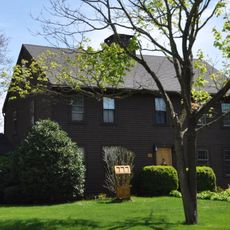
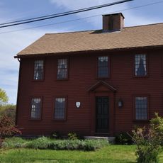
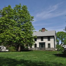
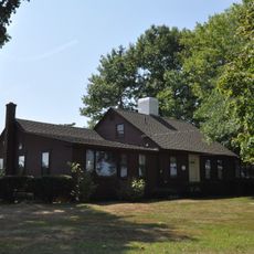
Nayatt Point Light is a square brick lighthouse at the entrance to Providence River in Rhode Island. The original 1828 structure included the tower and an attached keeper's house, which today stands as the oldest surviving lighthouse keeper's residence in the state.

The federal government funded construction of this lighthouse in 1828, though poor-quality contractors created structural problems that needed attention. Later improvements, including an advanced Fresnel lens, strengthened the tower's ability to guide ships safely through the channel.

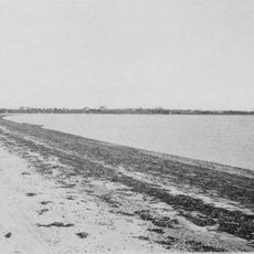
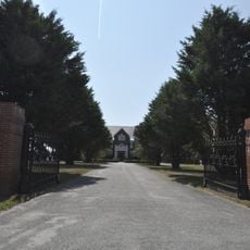
The lighthouse served as a vital navigation marker for vessels entering the river, helping captains safely steer through the narrow passage. Today, visitors can sense the connection between this place and the seafaring history of Rhode Island.

The area around the lighthouse is popular with birdwatchers and nature enthusiasts, especially during migration seasons. It's wise to wear sturdy shoes and pay attention to tide levels when exploring near the water.

The keeper's house is not only the oldest of its kind still standing in the state, but also displays authentic details from the era of lighthouse keepers. It offers visitors a rare glimpse into the everyday life of those who inhabited this isolated waterside location.

The community of curious travelers

AroundUs brings together thousands of curated places, local tips, and hidden gems, enriched daily by 60,000 contributors worldwide.

Start exploring
Location
Inception
1828
Height
7.5 m
GPS coordinates
41.72512,-71.33892
Latest update
December 14, 2025 11:41
Around this place
Aldrich Mansion
United States of America

Aldrich Mansion

5.8 km
Rocky Point Amusement Park
United States of America

Rocky Point Amusement Park

4.7 km
Crescent Park Looff Carousel
United States of America

Crescent Park Looff Carousel

3.9 km
Crescent Park
United States of America

Crescent Park

3.8 km
Rocky Point State Park
United States of America

Rocky Point State Park

4.6 km
Belton Court
United States of America

Belton Court

4.1 km
Conimicut Light
United States of America

Conimicut Light

1 km
Haines Memorial State Park
United States of America

Haines Memorial State Park

3 km
Barrington Civic Center Historic District
United States of America

Barrington Civic Center Historic District

3.1 km
Sabin Point Light
United States of America

Sabin Point Light

5 km
Barrington Beach
United States of America

Barrington Beach

2.5 km
Alfred Drowne Road Historic District
United States of America

Alfred Drowne Road Historic District

1.9 km
Moses Greene House
United States of America

Moses Greene House

3 km
St. Matthew's Episcopal Church
United States of America

St. Matthew's Episcopal Church

2 km
Warren Waterfront Historic District
United States of America

Warren Waterfront Historic District

4.6 km
O'Bannon Mill
United States of America

O'Bannon Mill

2.5 km
Peter Greene House
United States of America

Peter Greene House

3.3 km
John Waterman Arnold House
United States of America

John Waterman Arnold House

6 km
John R. Waterman House
United States of America

John R. Waterman House

4.7 km
Unitarian Church of Barnstable
United States of America

Unitarian Church of Barnstable

4.3 km
District 6 Schoolhouse
United States of America

District 6 Schoolhouse

5.5 km
Elm Tree Plat Historic District
United States of America

Elm Tree Plat Historic District

5.1 km
Rose Land Park Plat Historic District
United States of America

Rose Land Park Plat Historic District

5 km
Benjamin Aborn Jackson House
United States of America

Benjamin Aborn Jackson House

529 m
Greene-Durfee House
United States of America

Greene-Durfee House

3.7 km
Richard Wickes Greene House
United States of America

Richard Wickes Greene House

6 km
Allen-West House
United States of America

Allen-West House

5.7 km
Longfield
United States of America

Longfield

5.8 km
Show the full map
Reviews
Share your experience

No review yet

Discussions
Start a discussion...

No discussion yet

« Nayatt Point Light - Lighthouse in Barrington, Rhode Island » is provided by Around Us (aroundus.com). Images and texts are derived from Wikimedia project under a Creative Commons license. You are allowed to copy, distribute, and modify copies of this page, under the conditions set by the license, as long as this note is clearly visible.

Discover hidden gems everywhere you go!

From secret cafés to breathtaking viewpoints, skip the crowded tourist spots and find places that match your style. Our app makes it easy with voice search, smart filtering, route optimization, and insider tips from travelers worldwide. Download now for the complete mobile experience.

Around Us App Screenshot

A unique approach to discovering new places

Le Figaro

All the places worth exploring

France Info

A tailor-made excursion in just a few clicks

20 Minutes

Around Us
Travel Guide & Maps
Download

Send to your phone

QR Code
1

Open the camera app on your mobile.

2

Point at the QR code with your camera. A notification will appear.

3

Tap the notification to open the link.