National Weather Service Baltimore/Washington

Log in to your account

AroundUs is a community-driven map of interesting places, built by curious explorers like you. It grows with every review, story, and photo you share.
Connect to save your favorite spots, contribute locations, and create personalized routes.
By continuing, you accept our Terms and Conditions and our Privacy Policy

National Weather Service Baltimore/Washington

Add to collection
Map
Suggest a change
Share

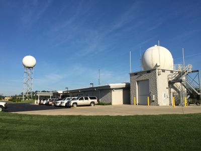
National Weather Service Baltimore/Washington, Weather monitoring station in Sterling, Virginia, United States.

The National Weather Service Baltimore/Washington in Sterling is a regional facility that collects atmospheric data from satellites, radars, and weather stations to produce forecasts and warnings. It serves multiple states and uses this information to help people and organizations plan their daily activities and prepare for severe weather.

This facility was established to monitor weather across a larger region and protect communities from dangerous atmospheric conditions. Over time its operational area has grown to include additional counties and expand the scope of its forecasting services.

The office maintains a SKYWARN program where local residents participate in weather observation and reporting, strengthening community involvement in meteorological activities.

Visitors can access current weather information, forecasts, and warnings online through a website or mobile application from anywhere. The data is continuously updated throughout the day to reflect changing atmospheric conditions in the region.

The facility maintains round-the-clock operations with staff working in rotating shifts to monitor weather at all hours. This constant watch means weather warnings and alerts can be issued immediately whenever dangerous conditions develop.

Location: Virginia

Website: https://weather.gov/lwx

GPS coordinates: 38.97649,-77.48562

Latest update: December 12, 2025 17:48

Photos
Around this place
Steven F. Udvar-Hazy Center
United States of America

Steven F. Udvar-Hazy Center

8.1 km
CIA University
United States of America

CIA University

8.3 km
Janelia Research Campus
United States of America

Janelia Research Campus

10.7 km
Sully Historic Site
United States of America

Sully Historic Site

10.1 km
A. Smith Bowman Distillery
United States of America

A. Smith Bowman Distillery

11.8 km
Belmont Manor House
United States of America

Belmont Manor House

10.4 km
Mount Zion Old School Baptist Church
United States of America

Mount Zion Old School Baptist Church

10.9 km
Arcola Elementary School
United States of America

Arcola Elementary School

5.5 km
Dranesville Tavern
United States of America

Dranesville Tavern

11.4 km
Broad Run Bridge and Tollhouse
United States of America

Broad Run Bridge and Tollhouse

9 km
Donald D. Engen Observation Tower
United States of America

Donald D. Engen Observation Tower

8.1 km
Arcola Slave Quarters
United States of America

Arcola Slave Quarters

4.8 km
Fleetwood Farm
United States of America

Fleetwood Farm

6.8 km
Merrybrook
United States of America

Merrybrook

7.1 km
Herndon Historic District
United States of America

Herndon Historic District

8.8 km
Ashburn Presbyterian Church
United States of America

Ashburn Presbyterian Church

6.9 km
Vestal's Gap Road and Lanesville Historic District
United States of America

Vestal's Gap Road and Lanesville Historic District

8.5 km
Frying Pan Meetinghouse
United States of America

Frying Pan Meetinghouse

7.5 km
Bloomfield
United States of America

Bloomfield

11.6 km
Floris Historic District
United States of America

Floris Historic District

8 km
Francis–Gulick Mill
United States of America

Francis–Gulick Mill

8.4 km
Loudoun Heritage Farm Museum
United States of America

Loudoun Heritage Farm Museum

8.4 km
Oak Hill
United States of America

Oak Hill

11.9 km
Wegmans
United States of America

Wegmans

11.6 km
Janelia
United States of America

Janelia

10.5 km
Ray Muth Sr. Memorial Park
United States of America

Ray Muth Sr. Memorial Park

6.8 km
Cascades Library
United States of America

Cascades Library

10.1 km
Ashburn Library
United States of America

Ashburn Library

7.8 km
Show the full map
Reviews

Visited this place? Tap the stars to rate it and share your experience / photos with the community! Try now! You can cancel it anytime.

« National Weather Service Baltimore/Washington - Weather monitoring station in Sterling, Virginia, United States » is provided by Around Us (aroundus.com). Images and texts are derived from Wikimedia project under a Creative Commons license. You are allowed to copy, distribute, and modify copies of this page, under the conditions set by the license, as long as this note is clearly visible.

Discover hidden gems everywhere you go!

From secret cafés to breathtaking viewpoints, skip the crowded tourist spots and find places that match your style. Our app makes it easy with voice search, smart filtering, route optimization, and insider tips from travelers worldwide. Download now for the complete mobile experience.

Around Us App Screenshot

A unique approach to discovering new places

Le Figaro

All the places worth exploring

France Info

A tailor-made excursion in just a few clicks

20 Minutes