Enable Location

We need your location to show you interesting places around you

Discover nearby places

Find interesting locations and hidden gems around you

Precise directions

Get accurate directions and distances to places

Your location is never shared with other users. It's only used when you tap the location button.

Arcola Slave Quarters

Log in to your account

Start exploring — it's free

Trusted by 63,105 travelers worldwide

Continue with Google
Continue with Apple
or

We will send you a code to connect

By continuing, you accept our Terms and Conditions and our Privacy Policy

Check your inbox

We've sent a pincode in your inbox. Please enter the code below.

Discussion Reviews 1 Photos
1.5k Popularity

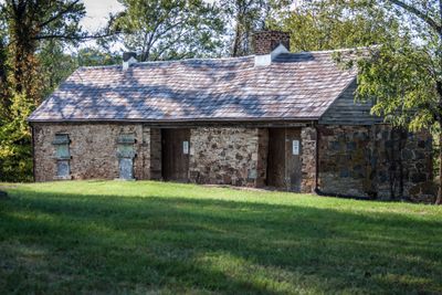
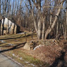
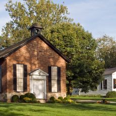
Arcola Slave Quarters, Stone slave quarters in Loudoun County, United States

The Arcola Slave Quarters consist of two separate stone sections with central chimneys and multiple rooms built into a hillside below the main residence. The floors are dirt, and the structure shows how living spaces were arranged on this early 19th-century property.

The buildings were constructed around 1800 on the Lewis plantation to house enslaved people whose population grew across generations. After the Civil War, formerly enslaved people and their descendants continued to occupy it as tenant farmers until the property changed ownership decades later.

The stone building reflects how people lived and worked on this property during slavery and the years that followed. Walking through it offers a direct sense of the cramped conditions and daily hardships residents faced.

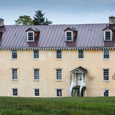
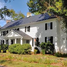
The structure sits at its original location next to a 1930s house that replaced the original plantation residence. Plan to walk the grounds carefully to take in the layout and understand how the buildings relate to each other on the property.

Stone construction was uncommon for this type of building, as most similar structures were made of wood. This unusual choice preserved the buildings far better than wooden alternatives, making them one of the few surviving examples from this period.

The community of curious travelers

AroundUs brings together thousands of curated places, local tips, and hidden gems, enriched daily by 60,000 contributors worldwide.

Start exploring
Location
Inception
1800
Address
24837 Evergreen Mills Road
GPS coordinates
38.94830,-77.52810
Latest update
December 14, 2025 15:02
Around this place
Enola Gay
United States of America

Enola Gay

8.4 km
Steven F. Udvar-Hazy Center
United States of America

Steven F. Udvar-Hazy Center

8.4 km
CIA University
United States of America

CIA University

9.4 km
Oatlands Plantation
United States of America

Oatlands Plantation

12.9 km
National Weather Service Baltimore/Washington
United States of America

National Weather Service Baltimore/Washington

4.8 km
Mount Zion Old School Baptist Church
United States of America

Mount Zion Old School Baptist Church

7.4 km
Arcola Elementary School
United States of America

Arcola Elementary School

764 m
Aldie Mill Historic District
United States of America

Aldie Mill Historic District

10.3 km
Donald D. Engen Observation Tower
United States of America

Donald D. Engen Observation Tower

8.4 km
Fleetwood Farm
United States of America

Fleetwood Farm

5.4 km
Merrybrook
United States of America

Merrybrook

10.4 km
Herndon Historic District
United States of America

Herndon Historic District

12.6 km
Ashburn Presbyterian Church
United States of America

Ashburn Presbyterian Church

10.7 km
Vestal's Gap Road and Lanesville Historic District
United States of America

Vestal's Gap Road and Lanesville Historic District

13.3 km
Frying Pan Meetinghouse
United States of America

Frying Pan Meetinghouse

10 km
Institute Farm
United States of America

Institute Farm

13.2 km
Furr Farm
United States of America

Furr Farm

12.9 km
Stoke
United States of America

Stoke

12.1 km
Floris Historic District
United States of America

Floris Historic District

10.5 km
Little River Turnpike Bridge
United States of America

Little River Turnpike Bridge

10.1 km
Locust Bottom
United States of America

Locust Bottom

11.5 km
Fair Oaks
United States of America

Fair Oaks

9.2 km
Francis–Gulick Mill
United States of America

Francis–Gulick Mill

9.2 km
Loudoun Heritage Farm Museum
United States of America

Loudoun Heritage Farm Museum

13.2 km
Oak Hill
United States of America

Oak Hill

9.7 km
Ray Muth Sr. Memorial Park
United States of America

Ray Muth Sr. Memorial Park

11.2 km
Oatlands Historic District
United States of America

Oatlands Historic District

12.1 km
Ashburn Library
United States of America

Ashburn Library

11 km
Show the full map
Reviews
Share your experience

No review yet

Discussions
Start a discussion...

No discussion yet

« Arcola Slave Quarters - Stone slave quarters in Loudoun County, United States » is provided by Around Us (aroundus.com). Images and texts are derived from Wikimedia project under a Creative Commons license. You are allowed to copy, distribute, and modify copies of this page, under the conditions set by the license, as long as this note is clearly visible.

Discover hidden gems everywhere you go!

From secret cafés to breathtaking viewpoints, skip the crowded tourist spots and find places that match your style. Our app makes it easy with voice search, smart filtering, route optimization, and insider tips from travelers worldwide. Download now for the complete mobile experience.

Around Us App Screenshot

A unique approach to discovering new places

Le Figaro

All the places worth exploring

France Info

A tailor-made excursion in just a few clicks

20 Minutes

Around Us
Travel Guide & Maps
Download

Send to your phone

QR Code
1

Open the camera app on your mobile.

2

Point at the QR code with your camera. A notification will appear.

3

Tap the notification to open the link.