Enable Location

We need your location to show you interesting places around you

Discover nearby places

Find interesting locations and hidden gems around you

Precise directions

Get accurate directions and distances to places

Your location is never shared with other users. It's only used when you tap the location button.

Log in to your account

Start exploring — it's free

Trusted by 68,290 travelers worldwide

Continue with Google
Continue with Apple
or

We will send you a code to connect

By continuing, you accept our Terms and Conditions and our Privacy Policy

Check your inbox

We've sent a pincode in your inbox. Please enter the code below.

Oyster Bay , New York
Discussion Reviews Photo
1.8k Popularity

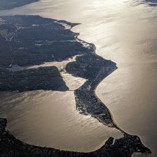
Oyster Bay , New York, Coastal inlet on Long Island Sound, New York, United States

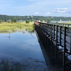
Oyster Bay is a coastal inlet along Long Island's north shore that stretches for several miles with deep, sheltered waters. The bay features shallow areas near the margins and deeper channels in the center that support different kinds of water activities.

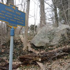
Native peoples lived here and harvested the bay's resources for centuries before the first colonial settlement arrived around 1653. Oyster harvesting then became the region's main industry for over two centuries, defining its economy and place names.

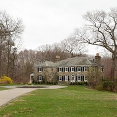
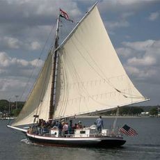
The waterfront shapes how people here live and spend their time, with sailing clubs and boat-building traditions that go back generations. You can see this connection to the water in the homes built facing the inlet and in how locals gather along the shore throughout the year.

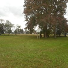
You can access the inlet at several points along its shore for fishing, boating, and swimming when the weather permits. Some areas have better facilities than others, so it helps to explore the waterfront to find the spots that suit your interests.

The oyster beds that gave the inlet its name still exist today and form a hidden ecosystem beneath the water's surface. These underwater structures support a wide variety of marine life and continue to influence the health of the entire bay.

The community of curious travelers

AroundUs brings together thousands of curated places, local tips, and hidden gems, enriched daily by 60,000 contributors worldwide.

Start exploring
Location
GPS coordinates
40.90120,-73.53570
Latest update
December 14, 2025 11:40
Around this place
Planting Fields Arboretum State Historic Park
United States of America

Planting Fields Arboretum State Historic Park

4.8 km
Youngs Memorial Cemetery
United States of America

Youngs Memorial Cemetery

4.2 km
Caumsett State Historic Park
United States of America

Caumsett State Historic Park

6.1 km
Sagamore Hill
United States of America

Sagamore Hill

3.7 km
Raynham Hall Museum
United States of America

Raynham Hall Museum

3.2 km
Theodore Roosevelt Memorial Park
United States of America

Theodore Roosevelt Memorial Park

2.9 km
Oyster Bay National Wildlife Refuge
United States of America

Oyster Bay National Wildlife Refuge

2.6 km
Christeen
United States of America

Christeen

2.6 km
John E. Aldred Estate
United States of America

John E. Aldred Estate

6.8 km
United States of America

Bayville Bridge

1.1 km
Cold Spring Harbor Light
United States of America

Cold Spring Harbor Light

3.9 km
Fort Hill Estate
United States of America

Fort Hill Estate

4.4 km
Fort Massapeag Archeological Site
United States of America

Fort Massapeag Archeological Site

3.8 km
Sagamore Hill
United States of America

Sagamore Hill

3.4 km
Moore's Building
United States of America

Moore's Building

3.2 km
Hood A.M.E. Zion Church
United States of America

Hood A.M.E. Zion Church

3.4 km
Wilson House
United States of America

Wilson House

3.3 km
Seely/Wright House
United States of America

Seely/Wright House

3.3 km
Council Rock
United States of America

Council Rock

3.1 km
Derby-Hall Bandstand
United States of America

Derby-Hall Bandstand

3.1 km
Charles Homer Davis House
United States of America

Charles Homer Davis House

6.8 km
Oyster Bay Bank Building
United States of America

Oyster Bay Bank Building

3.2 km
Fleet's Hall
United States of America

Fleet's Hall

3 km
Ludlam Building
United States of America

Ludlam Building

3.3 km
Roosevelt Museum at Old Orchard
United States of America

Roosevelt Museum at Old Orchard

3.7 km
Coe Hall
United States of America

Coe Hall

4.4 km
Lillian Sefton Dodge Estate
United States of America

Lillian Sefton Dodge Estate

3.3 km
Joseph Lloyd House
United States of America

Joseph Lloyd House

5 km
Show the full map
Reviews
Share your experience

No review yet

Discussions
Start a discussion...

No discussion yet

« Oyster Bay , New York - Coastal inlet on Long Island Sound, New York, United States » is provided by Around Us (aroundus.com). Images and texts are derived from Wikimedia project under a Creative Commons license. You are allowed to copy, distribute, and modify copies of this page, under the conditions set by the license, as long as this note is clearly visible.

Discover hidden gems everywhere you go!

From secret cafés to breathtaking viewpoints, skip the crowded tourist spots and find places that match your style. Our app makes it easy with voice search, smart filtering, route optimization, and insider tips from travelers worldwide. Download now for the complete mobile experience.

Around Us App Screenshot

A unique approach to discovering new places

Le Figaro

All the places worth exploring

France Info

A tailor-made excursion in just a few clicks

20 Minutes

Around Us
Travel Guide & Maps
Download

Send to your phone

QR Code
1

Open the camera app on your mobile.

2

Point at the QR code with your camera. A notification will appear.

3

Tap the notification to open the link.