Enable Location

We need your location to show you interesting places around you

Discover nearby places

Find interesting locations and hidden gems around you

Precise directions

Get accurate directions and distances to places

Your location is never shared with other users. It's only used when you tap the location button.

Partially Buried Woodshed

Log in to your account

Start exploring — it's free

Trusted by 63,370 travelers worldwide

Continue with Google
Continue with Apple
or

We will send you a code to connect

By continuing, you accept our Terms and Conditions and our Privacy Policy

Check your inbox

We've sent a pincode in your inbox. Please enter the code below.

Partially Buried Woodshed
Discussion Reviews 1 Photos
6k Popularity

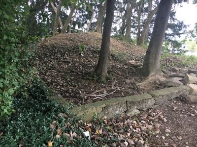
Partially Buried Woodshed, Land art sculpture in Kent State University, United States.

The Partially Buried Woodshed is a land art sculpture at Kent State University where an old wooden shed was covered with earth in the late 1960s. The central beam fractured under the weight in 1970, creating a dramatic visual break in the composition.

The sculpture was created in the late 1960s as a concept piece exploring physical transformation. Following the tragic shooting at Kent State in May 1970, the broken beam became marked with words that gave it unintended memorial significance.

The work explores themes of natural decay and how materials break down over time when exposed to the elements. Visitors can observe directly how this process unfolds on the remaining structure.

The work is located near the Liquid Crystal Institute on the southeastern edge of the campus. A concrete foundation and an explanatory plaque mark the site for visitors to understand what they are viewing.

The university removed all remaining wooden elements in 1984 following a serious fire and other destructive incidents on the site. What remains today is a ghostly impression of the original concept rather than the full structure.

The community of curious travelers

AroundUs brings together thousands of curated places, local tips, and hidden gems, enriched daily by 60,000 contributors worldwide.

Start exploring
Location
Inception
1970
GPS coordinates
41.14360,-81.33950
Latest update
December 9, 2025 18:45
Around this place
Dix Stadium
United States of America

Dix Stadium

2.2 km
Mary Campbell Cave
United States of America

Mary Campbell Cave

13.4 km
Shady Lake Park
United States of America

Shady Lake Park

11.6 km
Masonic Temple
United States of America

Masonic Temple

2.3 km
Kent Stage
United States of America

Kent Stage

1.8 km
Memorial Stadium
United States of America

Memorial Stadium

587 m
Franklin Hotel
United States of America

Franklin Hotel

2 km
Triangle Lake Bog State Nature Preserve
United States of America

Triangle Lake Bog State Nature Preserve

7.5 km
Kent Industrial District
United States of America

Kent Industrial District

2 km
Wills Gymnasium
United States of America

Wills Gymnasium

1.1 km
Rockwell Field
United States of America

Rockwell Field

2.2 km
Kent Free Library
United States of America

Kent Free Library

2.1 km
Tom S. Cooperrider-Kent Bog State Nature Preserve
United States of America

Tom S. Cooperrider-Kent Bog State Nature Preserve

2 km
Aaron Ferrey House
United States of America

Aaron Ferrey House

2.8 km
John Davey House
United States of America

John Davey House

2.7 km
Kent Jail
United States of America

Kent Jail

2.5 km
Charles Kent House
United States of America

Charles Kent House

2.5 km
Francis D. Alling House
United States of America

Francis D. Alling House

8.8 km
Franklin Township Hall
United States of America

Franklin Township Hall

2.2 km
First Congregational Church of Cuyahoga Falls
United States of America

First Congregational Church of Cuyahoga Falls

12.2 km
Hudson Historic District
United States of America

Hudson Historic District

14.1 km
West Main Street District
United States of America

West Main Street District

2.5 km
Maca Park
United States of America

Maca Park

7.6 km
Ohio State Normal College At Kent
United States of America

Ohio State Normal College At Kent

1.1 km
Kent State University Center for the Performing Arts
United States of America

Kent State University Center for the Performing Arts

999 m
May 4, 1970, Kent State Shootings Site
United States of America

May 4, 1970, Kent State Shootings Site

792 m
West Main Street Historic District
United States of America

West Main Street Historic District

2.3 km
Hudson Middle School
United States of America

Hudson Middle School

13.6 km
Show the full map
Reviews
Share your experience

No review yet

Discussions
Start a discussion...

No discussion yet

« Partially Buried Woodshed - Land art sculpture in Kent State University, United States » is provided by Around Us (aroundus.com). Images and texts are derived from Wikimedia project under a Creative Commons license. You are allowed to copy, distribute, and modify copies of this page, under the conditions set by the license, as long as this note is clearly visible.

Discover hidden gems everywhere you go!

From secret cafés to breathtaking viewpoints, skip the crowded tourist spots and find places that match your style. Our app makes it easy with voice search, smart filtering, route optimization, and insider tips from travelers worldwide. Download now for the complete mobile experience.

Around Us App Screenshot

A unique approach to discovering new places

Le Figaro

All the places worth exploring

France Info

A tailor-made excursion in just a few clicks

20 Minutes

Around Us
Travel Guide & Maps
Download

Send to your phone

QR Code
1

Open the camera app on your mobile.

2

Point at the QR code with your camera. A notification will appear.

3

Tap the notification to open the link.