Chest opened
+${chestReward.xp} XP
Explorer
NOUVEAU ×${chestReward.collectible.quantity}
tapez pour fermer
Chest locked

Open chests in the app

Around Us is built for your phone — chests unlock when you walk, explore and capture nearby places.

Enable Location

We need your location to show you interesting places around you

Discover nearby places

Find interesting locations and hidden gems around you

Precise directions

Get accurate directions and distances to places

Your location is never shared with other users. It's only used when you tap the location button.

Log in to your account

Start exploring — it's free

Trusted by 72,904 travelers worldwide

Continue with Google
Continue with Apple
or

We will send you a code to connect

By continuing, you accept our Terms and Conditions and our Privacy Policy

Check your inbox

We've sent a pincode in your inbox. Please enter the code below.

Plummer's Ledge Natural Area
Discussion Reviews Photo
1.3k Popularity

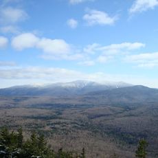
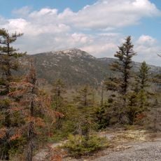
Plummer's Ledge Natural Area, Protected natural area in Wentworth, New Hampshire, United States.

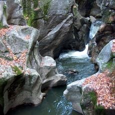
Plummer's Ledge Natural Area is a protected site in Wentworth featuring three massive cylindrical potholes carved into granite bedrock, with depths reaching 6 meters (20 feet). These striking formations dominate the landscape and create an unusual geological display on the sloped terrain.

George F. Plummer donated the property to New Hampshire in 1938, establishing its protected status under state management. The potholes themselves formed thousands of years ago at the end of the last glacial period through a slow process of water erosion.

Geologists study this location to understand the formation processes of glacial potholes through melting ice water during ancient geological periods.

Access is available from a parking area near Buffalo Road, a short drive from Wentworth village. Wear sturdy shoes since the granite surfaces are uneven and can be slippery, especially after rain or moisture.

The potholes formed when pebbles and sand were spun by glacial meltwater in circular motions, drilling into the granite like a natural bore. Such large cylindrical formations are relatively uncommon in New England.

The community of curious travelers

AroundUs brings together thousands of curated places, local tips, and hidden gems, enriched daily by 60,000 contributors worldwide.

Start exploring
Location
GPS coordinates
43.83500,-71.88420
Latest update
December 14, 2025 18:15
Around this place
Mount Moosilauke
United States of America

Mount Moosilauke

21.4 km
Mount Cardigan
United States of America

Mount Cardigan

20.8 km
Hubbard Brook Experimental Forest
United States of America

Hubbard Brook Experimental Forest

15.4 km
Sculptured Rocks Natural Area
United States of America

Sculptured Rocks Natural Area

14.4 km
Smarts Mountain
United States of America

Smarts Mountain

11.9 km
Wellington State Park
United States of America

Wellington State Park

21.6 km
Camp Walt Whitman
United States of America

Camp Walt Whitman

14.6 km
Lake Tarleton
United States of America

Lake Tarleton

16.9 km
Morey Memorial Bridge
United States of America

Morey Memorial Bridge

22 km
Blair Bridge
United States of America

Blair Bridge

17.8 km
Mount Blue
United States of America

Mount Blue

22.4 km
United States of America

Lake Tarleton State Park

18.1 km
Cardigan Mountain State Park
United States of America

Cardigan Mountain State Park

21.6 km
Canaan Street Historic District
United States of America

Canaan Street Historic District

22.7 km
Chapel of the Holy Cross
United States of America

Chapel of the Holy Cross

18.8 km
Orford Street Historic District
United States of America

Orford Street Historic District

21.6 km
Canaan Meetinghouse
United States of America

Canaan Meetinghouse

22.9 km
Dorchester Common Historic District
United States of America

Dorchester Common Historic District

10.2 km
Old Grafton County Courthouse
United States of America

Old Grafton County Courthouse

17.9 km
Norman and Marion Perry House
United States of America

Norman and Marion Perry House

15.3 km
Plymouth Historic District
United States of America

Plymouth Historic District

18 km
Fairlee Town Hall
United States of America

Fairlee Town Hall

22.3 km
Hebron Village Historic District
United States of America

Hebron Village Historic District

16.9 km
Owls Head
United States of America

Owls Head

19 km
Lyme Common Historic District
United States of America

Lyme Common Historic District

22.1 km
Moses Kent House
United States of America

Moses Kent House

22.7 km
Canaan Street Lake Beach
United States of America

Canaan Street Lake Beach

22.7 km
Orford-Fairlee Covered Bridge
United States of America

Orford-Fairlee Covered Bridge

22 km
Show the full map
Reviews
Share your experience

No review yet

Discussions
Start a discussion...

No discussion yet

« Plummer's Ledge Natural Area - Protected natural area in Wentworth, New Hampshire, United States » is provided by Around Us (aroundus.com). Images and texts are derived from Wikimedia project under a Creative Commons license. You are allowed to copy, distribute, and modify copies of this page, under the conditions set by the license, as long as this note is clearly visible.

Discover hidden gems everywhere you go!

From secret cafés to breathtaking viewpoints, skip the crowded tourist spots and find places that match your style. Our app makes it easy with voice search, smart filtering, route optimization, and insider tips from travelers worldwide. Download now for the complete mobile experience.

Around Us App Screenshot

A unique approach to discovering new places

Le Figaro

All the places worth exploring

France Info

A tailor-made excursion in just a few clicks

20 Minutes

Around Us
Travel Guide & Maps
Download

Send to your phone

QR Code
1

Open the camera app on your mobile.

2

Point at the QR code with your camera. A notification will appear.

3

Tap the notification to open the link.