Chest opened
+${chestReward.xp} XP
Explorer
NOUVEAU ×${chestReward.collectible.quantity}
tapez pour fermer
Chest locked

Open chests in the app

Around Us is built for your phone — chests unlock when you walk, explore and capture nearby places.

Enable Location

We need your location to show you interesting places around you

Discover nearby places

Find interesting locations and hidden gems around you

Precise directions

Get accurate directions and distances to places

Your location is never shared with other users. It's only used when you tap the location button.

Port of Indiana

Log in to your account

Start exploring — it's free

Trusted by 72,881 travelers worldwide

Continue with Google
Continue with Apple
or

We will send you a code to connect

By continuing, you accept our Terms and Conditions and our Privacy Policy

Check your inbox

We've sent a pincode in your inbox. Please enter the code below.

Port of Indiana
Discussion Reviews 1 Photos
7.7k Popularity

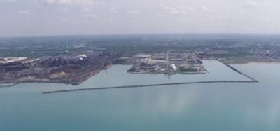
Port of Indiana, Maritime port in Burns Harbor, United States.

Port of Indiana is a major shipping facility on Lake Michigan that handles steel products, farm goods, and industrial materials. The installation features deep docking areas and extensive breakwaters that accommodate vessels using the Great Lakes shipping system.

Indiana Port Commission established this facility in 1961, with official operations beginning in 1970. The project was created to connect inland industries with the Great Lakes shipping network.

The port's construction transformed the Central Dunes region, which previously hosted early flight experiments and now stands as a symbol of industrial development.

This facility sits along the Lake Michigan shore near Burns Harbor and is accessible via the Great Lakes waterway. Keep in mind that this is an active industrial site with heavy vessel traffic, so viewing may be limited from certain areas.

A distinctive feature is its strategic position inland: ships departing from here can reach the Atlantic Ocean through the Great Lakes waterway system without returning to the coast. This connection transforms it into a gateway for moving goods between the country's interior and distant markets.

The community of curious travelers

AroundUs brings together thousands of curated places, local tips, and hidden gems, enriched daily by 60,000 contributors worldwide.

Start exploring
Location
GPS coordinates
41.64400,-87.15500
Latest update
December 10, 2025 15:46
Around this place
Indiana Dunes State Park
United States of America

Indiana Dunes State Park

9.7 km
Florida Tropical House
United States of America

Florida Tropical House

13.6 km
House of Tomorrow
United States of America

House of Tomorrow

13.6 km
United States of America

Mammals of the Indiana Dunes

3.9 km
Century of Progress Architectural District
United States of America

Century of Progress Architectural District

13.5 km
Marquette Park
United States of America

Marquette Park

9.2 km
Cowles Bog
United States of America

Cowles Bog

5.3 km
Josephus Wolf House
United States of America

Josephus Wolf House

12 km
Joseph Bailly Homestead
United States of America

Joseph Bailly Homestead

5.6 km
Gary Bathing Beach Aquatorium
United States of America

Gary Bathing Beach Aquatorium

8.9 km
Armco-Ferro House
United States of America

Armco-Ferro House

13.5 km
Wieboldt-Rostone House
United States of America

Wieboldt-Rostone House

13.5 km
Cypress Log Cabin
United States of America

Cypress Log Cabin

13.6 km
Calumet Trail
United States of America

Calumet Trail

6.3 km
George Brown Mansion
United States of America

George Brown Mansion

8.9 km
Bartlett Real Estate Office
United States of America

Bartlett Real Estate Office

14.4 km
Chesterton Commercial Historic District
United States of America

Chesterton Commercial Historic District

9.3 km
Norris and Harriet Coambs Lustron House
United States of America

Norris and Harriet Coambs Lustron House

9.2 km
Dr. John and Gerda Meyer House
United States of America

Dr. John and Gerda Meyer House

13 km
Chesterton Residential Historic District
United States of America

Chesterton Residential Historic District

9.3 km
Read Dunes House
United States of America

Read Dunes House

8.9 km
Good Fellow Club Youth Camp
United States of America

Good Fellow Club Youth Camp

4.9 km
Martin Young House
United States of America

Martin Young House

9.3 km
Hobart Commercial District
United States of America

Hobart Commercial District

15 km
Dune Acres Clubhouse
United States of America

Dune Acres Clubhouse

5.8 km
Porter Town Hall
United States of America

Porter Town Hall

7.5 km
Indiana Dunes Visitor Center
United States of America

Indiana Dunes Visitor Center

8.5 km
Crisman Road Bridge
United States of America

Crisman Road Bridge

3.8 km
Show the full map
Reviews
Share your experience

No review yet

Discussions
Start a discussion...

No discussion yet

« Port of Indiana - Maritime port in Burns Harbor, United States » is provided by Around Us (aroundus.com). Images and texts are derived from Wikimedia project under a Creative Commons license. You are allowed to copy, distribute, and modify copies of this page, under the conditions set by the license, as long as this note is clearly visible.

Discover hidden gems everywhere you go!

From secret cafés to breathtaking viewpoints, skip the crowded tourist spots and find places that match your style. Our app makes it easy with voice search, smart filtering, route optimization, and insider tips from travelers worldwide. Download now for the complete mobile experience.

Around Us App Screenshot

A unique approach to discovering new places

Le Figaro

All the places worth exploring

France Info

A tailor-made excursion in just a few clicks

20 Minutes

Around Us
Travel Guide & Maps
Download

Send to your phone

QR Code
1

Open the camera app on your mobile.

2

Point at the QR code with your camera. A notification will appear.

3

Tap the notification to open the link.