Enable Location

We need your location to show you interesting places around you

Discover nearby places

Find interesting locations and hidden gems around you

Precise directions

Get accurate directions and distances to places

Your location is never shared with other users. It's only used when you tap the location button.

Providence City Hall

Log in to your account

Start exploring — it's free

Trusted by 61,619 travelers worldwide

Continue with Google
Continue with Apple
or

We will send you a code to connect

By continuing, you accept our Terms and Conditions and our Privacy Policy

Check your inbox

We've sent a pincode in your inbox. Please enter the code below.

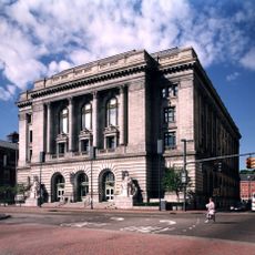
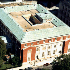
Providence City Hall, Government building in Providence, United States

Description

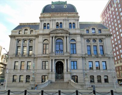
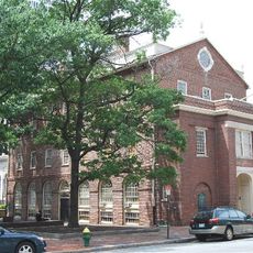
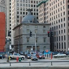
Providence City Hall stands at the intersection of Dorrance and Washington Streets, displaying a mansard roof with decorative stone elements in Second Empire style. The four-story building houses municipal offices and a council chamber that serve as the administrative and political center of the city.

History

Designed by architect Samuel J. F. Thayer, the building opened in 1878 after three years of construction. It was built during a period when Providence was developing into an important industrial and commercial center.

Culture

The interior spaces display murals, portraits, and decorative elements that tell the story of Providence's growth over time. These artworks reflect how the city saw itself and what it valued at different points in its development.

Practical

The building is accessible on weekdays during business hours, though some areas may be restricted to authorized visitors. It is best to check ahead to learn which sections are open to the public and whether tours are available.

Did you know?

Local craftspeople and materials were specifically chosen for construction, giving the building regional architectural character. This choice made it an early example of supporting local craft traditions in civic architecture.

Location
Inception
1878
Architects
Samuel J. F. Thayer
Architectural style
Second Empire style
GPS coordinates
41.82417,-71.41272
Latest update
December 10, 2025 20:01

AroundUs brings together thousands of curated places, local tips, and hidden gems, enriched daily by 60,000 contributors worldwide. Discover all places nearby (Rhode Island).

Around this place
111 Westminster Street
United States of America

111 Westminster Street

174 m
Providence Biltmore
United States of America

Providence Biltmore

73 m
Westminster Arcade
United States of America

Westminster Arcade

169 m
Providence Performing Arts Center
United States of America

Providence Performing Arts Center

309 m
Omni Providence Hotel
United States of America

Omni Providence Hotel

314 m
Textron Tower
United States of America

Textron Tower

315 m
Waterplace Park
United States of America

Waterplace Park

315 m
Turk's Head Building
United States of America

Turk's Head Building

239 m
50 Kennedy Plaza
United States of America

50 Kennedy Plaza

197 m
Market House
United States of America

Market House

374 m
Burnside Park, Providence, Rhode Island
United States of America

Burnside Park, Providence, Rhode Island

145 m
Grace Church
United States of America

Grace Church

270 m
Rhode Island Hospital Trust Building
United States of America

Rhode Island Hospital Trust Building

300 m
Federal Building
United States of America

Federal Building

228 m
Waterplace
United States of America

Waterplace

348 m
Crawford Street Bridge
United States of America

Crawford Street Bridge

400 m
Union Trust Company Building
United States of America

Union Trust Company Building

128 m
United States Customshouse
United States of America

United States Customshouse

228 m
Providence Telephone Building
United States of America

Providence Telephone Building

119 m
Merchants Bank Building
United States of America

Merchants Bank Building

234 m
Customhouse Historic District
United States of America

Customhouse Historic District

251 m
Hope Block and Cheapside
United States of America

Hope Block and Cheapside

385 m
La Gondola Providence, Inc.
United States of America

La Gondola Providence, Inc.

379 m
The Residences Providence
United States of America

The Residences Providence

231 m
One Financial Plaza
United States of America

One Financial Plaza

259 m
World War I Monument
United States of America

World War I Monument

419 m
One Citizens Plaza
United States of America

One Citizens Plaza

397 m
John O. Pastore Federal Building
United States of America

John O. Pastore Federal Building

273 m
Show the full map
« Providence City Hall - Government building in Providence, United States » is provided by Around Us (aroundus.com). Images and texts are derived from Wikimedia project under a Creative Commons license. You are allowed to copy, distribute, and modify copies of this page, under the conditions set by the license, as long as this note is clearly visible.

Discover hidden gems everywhere you go!

From secret cafés to breathtaking viewpoints, skip the crowded tourist spots and find places that match your style. Our app makes it easy with voice search, smart filtering, route optimization, and insider tips from travelers worldwide. Download now for the complete mobile experience.

Around Us App Screenshot

A unique approach to discovering new places

Le Figaro

All the places worth exploring

France Info

A tailor-made excursion in just a few clicks

20 Minutes

Around Us
Travel Guide & Maps
Download

Send to your phone

QR Code
1

Open the camera app on your mobile.

2

Point at the QR code with your camera. A notification will appear.

3

Tap the notification to open the link.