Chest opened
+${chestReward.xp} XP
Explorer
NOUVEAU ×${chestReward.collectible.quantity}
tapez pour fermer
Chest locked

Open chests in the app

Around Us is built for your phone — chests unlock when you walk, explore and capture nearby places.

Enable Location

We need your location to show you interesting places around you

Discover nearby places

Find interesting locations and hidden gems around you

Precise directions

Get accurate directions and distances to places

Your location is never shared with other users. It's only used when you tap the location button.

Log in to your account

Start exploring — it's free

Trusted by 72,884 travelers worldwide

Continue with Google
Continue with Apple
or

We will send you a code to connect

By continuing, you accept our Terms and Conditions and our Privacy Policy

Check your inbox

We've sent a pincode in your inbox. Please enter the code below.

Rollins State Park
Discussion Reviews Photo
1.8k Popularity

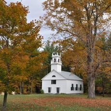
Rollins State Park, State park on Mount Kearsarge, New Hampshire, United States.

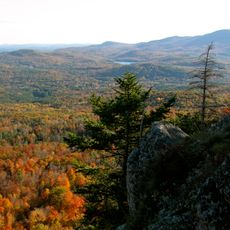
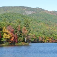
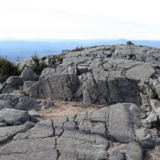
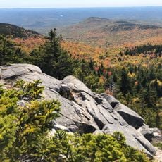
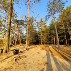
Rollins State Park is a recreation area on Mount Kearsarge accessible by a 3.5-mile road that climbs through forests. The road leads to a parking area near the summit where visitors find open views and picnic facilities.

Frank W. Rollins, who served as governor from 1899 to 1901, donated this land to create a place for outdoor recreation. The area was later developed and maintained as a state park.

The park is named after Frank W. Rollins, a former governor who wanted to open nature to the public. Today it serves as a gathering place for hikers and nature lovers from across the region.

The drive up the road is straightforward and needs no special vehicle or experience. Visitors should check the weather before going, since rain can make the road slippery.

On clear days, visitors from the Garden picnic area can see multiple mountains and even distant views toward the coast. This long-range view is often overlooked despite being one of the park's finest features.

The community of curious travelers

AroundUs brings together thousands of curated places, local tips, and hidden gems, enriched daily by 60,000 contributors worldwide.

Start exploring
Location
GPS coordinates
43.34580,-71.85000
Latest update
December 14, 2025 12:25
Around this place
Mount Kearsarge
United States of America

Mount Kearsarge

4.2 km
The Fells
United States of America

The Fells

15.9 km
Ragged Mountain
United States of America

Ragged Mountain

14.1 km
Winslow State Park
United States of America

Winslow State Park

5.1 km
Bement Covered Bridge
United States of America

Bement Covered Bridge

12.4 km
Waterloo Historic District
United States of America

Waterloo Historic District

6.4 km
Waterloo Covered Bridge
United States of America

Waterloo Covered Bridge

6.4 km
Bog Bridge
United States of America

Bog Bridge

9.5 km
South Danbury Christian Church
United States of America

South Danbury Christian Church

15.5 km
Kearsarge Mountain State Forest
United States of America

Kearsarge Mountain State Forest

4.2 km
Dalton Covered Bridge
United States of America

Dalton Covered Bridge

8.3 km
Old Webster Meeting House
United States of America

Old Webster Meeting House

10.9 km
New Hampshire Telephone Museum
United States of America

New Hampshire Telephone Museum

7.9 km
Keniston Bridge
United States of America

Keniston Bridge

10 km
Baptist New Meeting House
United States of America

Baptist New Meeting House

13 km
South Sutton Meeting House
United States of America

South Sutton Meeting House

7.5 km
Center Meetinghouse
United States of America

Center Meetinghouse

15.3 km
Matthew Harvey House
United States of America

Matthew Harvey House

9.1 km
Dr. Solomon M. Whipple House
United States of America

Dr. Solomon M. Whipple House

13.2 km
Salisbury Academy Building
United States of America

Salisbury Academy Building

11.5 km
Bradford Town Hall
United States of America

Bradford Town Hall

12.4 km
Pillsbury Memorial Hall
United States of America

Pillsbury Memorial Hall

8.5 km
East Andover Village Center Historic District
United States of America

East Andover Village Center Historic District

15.1 km
Lower Warner Meetinghouse
United States of America

Lower Warner Meetinghouse

8.9 km
Gershom Durgin House
United States of America

Gershom Durgin House

12.6 km
Bradford Center Meetinghouse
United States of America

Bradford Center Meetinghouse

15.6 km
Wadleigh State Beach
United States of America

Wadleigh State Beach

8.1 km
Bucklin Beach
United States of America

Bucklin Beach

15.8 km
Show the full map
Reviews
Share your experience

No review yet

Discussions
Start a discussion...

No discussion yet

« Rollins State Park - State park on Mount Kearsarge, New Hampshire, United States » is provided by Around Us (aroundus.com). Images and texts are derived from Wikimedia project under a Creative Commons license. You are allowed to copy, distribute, and modify copies of this page, under the conditions set by the license, as long as this note is clearly visible.

Discover hidden gems everywhere you go!

From secret cafés to breathtaking viewpoints, skip the crowded tourist spots and find places that match your style. Our app makes it easy with voice search, smart filtering, route optimization, and insider tips from travelers worldwide. Download now for the complete mobile experience.

Around Us App Screenshot

A unique approach to discovering new places

Le Figaro

All the places worth exploring

France Info

A tailor-made excursion in just a few clicks

20 Minutes

Around Us
Travel Guide & Maps
Download

Send to your phone

QR Code
1

Open the camera app on your mobile.

2

Point at the QR code with your camera. A notification will appear.

3

Tap the notification to open the link.