Rosebud Battlefield State Park

Log in to your account

AroundUs is a community-driven map of interesting places, built by curious explorers like you. It grows with every review, story, and photo you share.
Connect to save your favorite spots, contribute locations, and create personalized routes.
Continue with Google
Continue with Apple
Continue with X
Continue with Facebook
Continue with email
By continuing, you accept our Terms and Conditions and our Privacy Policy
Create an account
Add to collection
Map
Suggest a change
Share

Rosebud Battlefield State Park, Historic battlefield state park in southeastern Montana, United States.

Rosebud Battlefield State Park sits on rolling prairie in southeastern Montana near the Little Bighorn River, where the land slopes gently across high elevation terrain. The site includes an information station, basic facilities, and gravel roads that help visitors navigate where the fighting occurred.

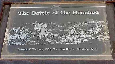
On June 17, 1876, Native American warriors led by Crazy Horse launched an organized assault against General Crook's troops, forcing them to withdraw from the area. This withdrawal became significant because it left nearby military commanders without Crook's support when they faced Custer days later at Little Bighorn.

The Northern Cheyenne know this place as the site where Buffalo Calf Road Woman rescued her wounded brother during fighting, a story that shapes how the land is understood today. The landscape itself holds this memory, connecting visitors to the indigenous perspective of what happened here.

The terrain sits at high elevation and can be quite windy, so visitors should dress appropriately for changing weather. Using the information stations helps orient yourself to the layout before walking the gravel roads across the prairie.

This clash was a turning point in the conflict between the United States and the Lakota people, as events here directly shaped what happened at Little Bighorn just over a week later. Many visitors are surprised to learn that this lesser-known engagement had such direct influence on the more famous battle nearby.

Location: Montana

Website: https://fwp.mt.gov/stateparks/rosebud-battlefield

GPS coordinates: 45.23056,-106.99778

Latest update: December 10, 2025 20:04

Photos
Around this place
Medicine Wheel/Medicine Mountain National Historic Landmark
United States of America

Medicine Wheel/Medicine Mountain National Historic Landmark

85.5 km
Fort Phil Kearny
United States of America

Fort Phil Kearny

78.9 km
Little Bighorn Battlefield National Monument
United States of America

Little Bighorn Battlefield National Monument

50.6 km
Sheridan Inn
United States of America

Sheridan Inn

47.4 km
Black Tooth Mountain
United States of America

Black Tooth Mountain

93.2 km
Shell Falls
United States of America

Shell Falls

86.6 km
Bighorn Lake
United States of America

Bighorn Lake

75.6 km
Tongue River Reservoir State Park
United States of America

Tongue River Reservoir State Park

21.6 km
Deer Medicine Rocks
United States of America

Deer Medicine Rocks

57 km
Wolf Mountains Battlefield
United States of America

Wolf Mountains Battlefield

33.2 km
Trail End
United States of America

Trail End

47.8 km
Mount Woolsey
United States of America

Mount Woolsey

93.4 km
Bighorn Ditch Headgate
United States of America

Bighorn Ditch Headgate

75.3 km
Sheridan County Courthouse
United States of America

Sheridan County Courthouse

48.6 km
CKW Bridge over Powder River
United States of America

CKW Bridge over Powder River

91.6 km
ECR Kooi Bridge
United States of America

ECR Kooi Bridge

36.5 km
ECS Bridge over Big Goose Creek
United States of America

ECS Bridge over Big Goose Creek

55.2 km
EAU Arvada Bridge
United States of America

EAU Arvada Bridge

93.3 km
Holy Name Catholic School
United States of America

Holy Name Catholic School

48.6 km
St. Joseph's Catholic Church
United States of America

St. Joseph's Catholic Church

73.7 km
EBF Bridge over Powder River
United States of America

EBF Bridge over Powder River

83.3 km
Mount View
United States of America

Mount View

48.9 km
Odd Fellows Hall
United States of America

Odd Fellows Hall

61.4 km
First Baptist Church
United States of America

First Baptist Church

73.5 km
Susan Wissler House
United States of America

Susan Wissler House

44.8 km
St. Peter's Episcopal Church
United States of America

St. Peter's Episcopal Church

48.4 km
Robinson-Smith House
United States of America

Robinson-Smith House

48.9 km
John Boyum House
United States of America

John Boyum House

73.7 km
Show the full map
Reviews

Visited this place? Tap the stars to rate it and share your experience / photos with the community! Try now! You can cancel it anytime.

« Rosebud Battlefield State Park - Historic battlefield state park in southeastern Montana, United States » is provided by Around Us (aroundus.com). Images and texts are derived from Wikimedia project under a Creative Commons license. You are allowed to copy, distribute, and modify copies of this page, under the conditions set by the license, as long as this note is clearly visible.

Discover hidden gems everywhere you go!

From secret cafés to breathtaking viewpoints, skip the crowded tourist spots and find places that match your style. Our app makes it easy with voice search, smart filtering, route optimization, and insider tips from travelers worldwide. Download now for the complete mobile experience.

Around Us App Screenshot

A unique approach to discovering new places

Le Figaro

All the places worth exploring

France Info

A tailor-made excursion in just a few clicks

20 Minutes