Enable Location

We need your location to show you interesting places around you

Discover nearby places

Find interesting locations and hidden gems around you

Precise directions

Get accurate directions and distances to places

Your location is never shared with other users. It's only used when you tap the location button.

Sagamore Bridge

Log in to your account

Start exploring — it's free

Trusted by 61,808 travelers worldwide

Continue with Google
Continue with Apple
or

We will send you a code to connect

By continuing, you accept our Terms and Conditions and our Privacy Policy

Check your inbox

We've sent a pincode in your inbox. Please enter the code below.

Sagamore Bridge, Through arch bridge in Sagamore, Massachusetts, United States.

Description

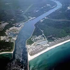
Sagamore Bridge is a steel through arch bridge spanning the Cape Cod Canal in Bourne, Massachusetts, United States. The tall arch rises above the waterway, linking the mainland to the narrow neck of the peninsula.

History

Construction began during the Great Depression as a federal work relief project and the bridge opened in the summer of 1935. This span replaced an earlier drawbridge that could no longer handle growing traffic.

Culture

The bridge name recalls an Algonquin tradition and commemorates a leading Wampanoag sachem. Anyone crossing this span by car or foot enters the long peninsula of Cape Cod, where tens of thousands of visitors start their beach holidays each year.

Practical

Pedestrians and cyclists use the eastern sidewalk, which runs nearly two meters wide and is separated from roadway traffic by a railing. Route 6 passes through the roadway section and leads to the eastern end of the canal, where several parking areas offer views of the waterway.

Did you know?

The engineers used an almost identical design for this span alongside the parallel Bourne Bridge, making both structures appear as twins. Many visitors notice the visual similarity only after crossing both passages one after the other.

Location
Inception
June 22, 1935
Architects
Cram and Ferguson Architects, Fay, Spofford & Thorndike
Official opening
June 22, 1935
Height
83.82 m
Length
429 m
GPS coordinates
41.77610,-70.54340
Latest update
December 5, 2025 22:28

AroundUs brings together thousands of curated places, local tips, and hidden gems, enriched daily by 60,000 contributors worldwide. Discover all places nearby (Bourne).

Around this place
Cape Cod Canal
United States of America

Cape Cod Canal

2.5 km
Bourne Bridge
United States of America

Bourne Bridge

5 km
Cape Cod Canal Railroad Bridge
United States of America

Cape Cod Canal Railroad Bridge

7 km
Scusset Beach State Reservation
United States of America

Scusset Beach State Reservation

3.5 km
Heritage Museums and Gardens
United States of America

Heritage Museums and Gardens

4.5 km
Sandwich Glass Museum
United States of America

Sandwich Glass Museum

4.1 km
Hoxie House
United States of America

Hoxie House

4.4 km
Fort Banks
United States of America

Fort Banks

8 km
Ellisville Harbor State Park
United States of America

Ellisville Harbor State Park

7.7 km
Wing Fort House
United States of America

Wing Fort House

7 km
Shawme-Crowell State Forest
United States of America

Shawme-Crowell State Forest

2.3 km
Pine Hill
United States of America

Pine Hill

7.7 km
First Church, Sandwich Massachusetts
United States of America

First Church, Sandwich Massachusetts

4.2 km
Jonathan Bourne Public Library
United States of America

Jonathan Bourne Public Library

5.9 km
Bourne Town Hall
United States of America

Bourne Town Hall

5.8 km
Jarvesville Historic District
United States of America

Jarvesville Historic District

4.5 km
John and Mary Waterman Jarves House
United States of America

John and Mary Waterman Jarves House

4.4 km
George I. Briggs House
United States of America

George I. Briggs House

5.9 km
Spring Hill Historic District (Sandwich, Massachusetts)
United States of America

Spring Hill Historic District (Sandwich, Massachusetts)

6.6 km
Town Hall Square Historic District
United States of America

Town Hall Square Historic District

4 km
Old Bourne High School building
United States of America

Old Bourne High School building

5.7 km
East Sandwich Beach
United States of America

East Sandwich Beach

8.3 km
Springhill Beach
United States of America

Springhill Beach

7.8 km
Monument Beach
United States of America

Monument Beach

9 km
Town Beach
United States of America

Town Beach

4.3 km
Scusset Beach
United States of America

Scusset Beach

3.4 km
Indian Mound Beach
United States of America

Indian Mound Beach

7.5 km
Sagamore Beach
United States of America

Sagamore Beach

2.7 km
Show the full map
« Sagamore Bridge - Through arch bridge in Sagamore, Massachusetts, United States » is provided by Around Us (aroundus.com). Images and texts are derived from Wikimedia project under a Creative Commons license. You are allowed to copy, distribute, and modify copies of this page, under the conditions set by the license, as long as this note is clearly visible.

Discover hidden gems everywhere you go!

From secret cafés to breathtaking viewpoints, skip the crowded tourist spots and find places that match your style. Our app makes it easy with voice search, smart filtering, route optimization, and insider tips from travelers worldwide. Download now for the complete mobile experience.

Around Us App Screenshot

A unique approach to discovering new places

Le Figaro

All the places worth exploring

France Info

A tailor-made excursion in just a few clicks

20 Minutes

Around Us
Travel Guide & Maps
Download

Send to your phone

QR Code
1

Open the camera app on your mobile.

2

Point at the QR code with your camera. A notification will appear.

3

Tap the notification to open the link.