Satan's Kingdom State Recreation Area

Log in to your account

AroundUs is a community-driven map of interesting places, built by curious explorers like you. It grows with every review, story, and photo you share.
Connect to save your favorite spots, contribute locations, and create personalized routes.
Continue with Google
Continue with Apple
Continue with X
Continue with Facebook
Continue with email
By continuing, you accept our Terms and Conditions and our Privacy Policy
Create an account

Satan's Kingdom State Recreation Area

Add to collection
Map
Suggest a change
Share

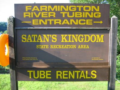
Satan's Kingdom State Recreation Area, Protected area along Farmington River in New Hartford, United States

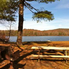
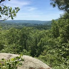
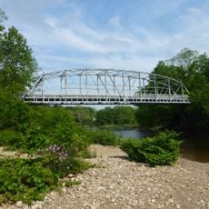
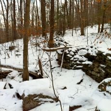
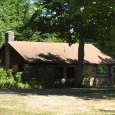
Satan's Kingdom State Recreation Area is a protected area along the Farmington River in New Hartford offering access to water and hiking activities. The site includes rapids and calmer river sections that extend over several miles, providing different options for paddlers and swimmers.

The name came about in the 1870s during construction of the New Haven and Northampton Railroad, when workers struggled to navigate through the river gorge. The difficult passage inspired the dark name that has stuck with the place ever since.

The site draws visitors year-round for water-based activities, with summer being the busiest season when paddlers and tubers frequent the river. The area has become a gathering place where people from nearby towns come to enjoy outdoor recreation together on the water.

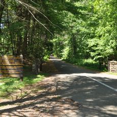
The area is accessed via Route 44 where parking is available, allowing visitors to reach the river and connect to nearby hiking trails. Water levels are best for paddling after rainfall, while most guests visit during the warm months.

The recreation area connects directly to hiking trails in the adjacent Nepaug State Forest through Satan's Kingdom Road, allowing visitors to combine water activities with forest walks. This convenient link makes it easy to explore both river and woodland settings in one visit.

Location: Connecticut

Website: https://portal.ct.gov/deep/state-parks/locate-park-forest/other-state-parks-and-forests

GPS coordinates: 41.85556,-72.95722

Latest update: December 9, 2025 18:40

Photos
Around this place
Connecticut Governor's Residence
United States of America

Connecticut Governor's Residence

22 km
Gilbert Clock Factory
United States of America

Gilbert Clock Factory

11.8 km
Burr Pond State Park
United States of America

Burr Pond State Park

11.4 km
Peoples State Forest
United States of America

Peoples State Forest

8.9 km
Pine Meadow Historic District
United States of America

Pine Meadow Historic District

2.4 km
Nepaug State Forest
United States of America

Nepaug State Forest

2 km
Stratton Brook State Park
United States of America

Stratton Brook State Park

10.1 km
Town Bridge
United States of America

Town Bridge

4.2 km
Canton Center Historic District
United States of America

Canton Center Historic District

3.4 km
American Legion State Forest
United States of America

American Legion State Forest

10 km
Horse Guard State Park
United States of America

Horse Guard State Park

9.9 km
American Legion State Forest Trails
United States of America

American Legion State Forest Trails

9.7 km
Avon Congregational Church
United States of America

Avon Congregational Church

11.6 km
Sun Terrace
United States of America

Sun Terrace

4.6 km
Barkhamsted Center Historic District
United States of America

Barkhamsted Center Historic District

8.3 km
Philip Chapin House
United States of America

Philip Chapin House

2.4 km
Peoples State Forest Nature Museum
United States of America

Peoples State Forest Nature Museum

8.5 km
Gillette's Grist Mill
United States of America

Gillette's Grist Mill

5.9 km
United States of America

John Wiard House

9.1 km
Massaco Forest Pavilion
United States of America

Massaco Forest Pavilion

10.1 km
Esperanza
United States of America

Esperanza

3.7 km
American Legion Forest CCC Shelter
United States of America

American Legion Forest CCC Shelter

9.1 km
Winsted Green Historic District
United States of America

Winsted Green Historic District

11.3 km
Brown Tavern
United States of America

Brown Tavern

9.7 km
Winsted Hosiery Mill
United States of America

Winsted Hosiery Mill

11.3 km
Paugnut State Forest Administration Building
United States of America

Paugnut State Forest Administration Building

11.4 km
Burlington–Harmony Hill Roads Historic District
United States of America

Burlington–Harmony Hill Roads Historic District

11.7 km
United States of America

Treadwell House

9.7 km
Show the full map
Reviews

Visited this place? Tap the stars to rate it and share your experience / photos with the community! Try now! You can cancel it anytime.

« Satan's Kingdom State Recreation Area - Protected area along Farmington River in New Hartford, United States » is provided by Around Us (aroundus.com). Images and texts are derived from Wikimedia project under a Creative Commons license. You are allowed to copy, distribute, and modify copies of this page, under the conditions set by the license, as long as this note is clearly visible.

Discover hidden gems everywhere you go!

From secret cafés to breathtaking viewpoints, skip the crowded tourist spots and find places that match your style. Our app makes it easy with voice search, smart filtering, route optimization, and insider tips from travelers worldwide. Download now for the complete mobile experience.

Around Us App Screenshot

A unique approach to discovering new places

Le Figaro

All the places worth exploring

France Info

A tailor-made excursion in just a few clicks

20 Minutes