Enable Location

We need your location to show you interesting places around you

Discover nearby places

Find interesting locations and hidden gems around you

Precise directions

Get accurate directions and distances to places

Your location is never shared with other users. It's only used when you tap the location button.

South Fountain Avenue Historic District

Log in to your account

Start exploring — it's free

Trusted by 62,615 travelers worldwide

Continue with Google
Continue with Apple
or

We will send you a code to connect

By continuing, you accept our Terms and Conditions and our Privacy Policy

Check your inbox

We've sent a pincode in your inbox. Please enter the code below.

South Fountain Avenue Historic District

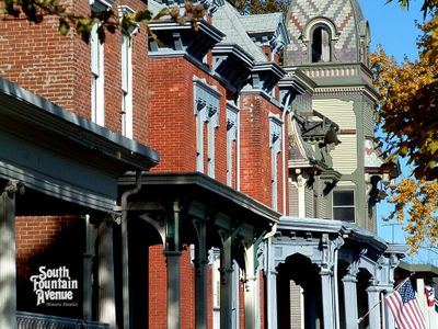
South Fountain Avenue Historic District, Victorian residential district in Springfield, United States

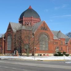
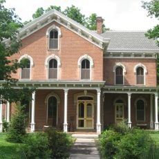
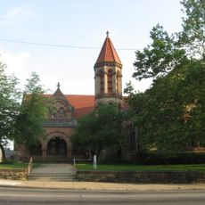
South Fountain Avenue Historic District is a residential neighborhood with homes from the late 1800s and early 1900s that display careful design and skilled craftsmanship. The area spans about 15 blocks with well-preserved buildings arranged in a connected layout.

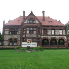
The neighborhood grew during Springfield's economic boom between 1850 and 1920, when wealthy business leaders and industrialists built homes here. This period of prosperity shaped the building styles and architectural variety.

The homes display various architectural styles like Greek Revival and Queen Anne that you notice while walking through the streets. Each style shapes the look of the neighborhood and reflects different tastes of the people who lived here.

The neighborhood is easy to explore on foot, with homes arranged close together in manageable blocks. It helps to walk slowly and observe the details of the facades and windows as you pass each house.

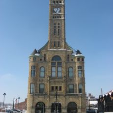
One house in the area had a private observatory for watching the stars that connected to a public clock. This unusual link shows the inventive spirit and ambitions of the wealthy residents.

The community of curious travelers

AroundUs brings together thousands of curated places, local tips, and hidden gems, enriched daily by 60,000 contributors worldwide.

Start exploring
Location
GPS coordinates
39.91589,-83.81215
Latest update
December 14, 2025 18:12
Around this place
Westcott House
United States of America

Westcott House

2.1 km
Little Miami Scenic Trail
United States of America

Little Miami Scenic Trail

13.7 km
John Bryan State Park
United States of America

John Bryan State Park

14.2 km
Glen Helen Nature Preserve
United States of America

Glen Helen Nature Preserve

14.4 km
Buck Creek State Park
United States of America

Buck Creek State Park

9.7 km
Whitelaw Reid House
United States of America

Whitelaw Reid House

18.4 km
East High Street Historic District
United States of America

East High Street Historic District

1.5 km
Clifton Gorge State Nature Preserve
United States of America

Clifton Gorge State Nature Preserve

14.3 km
Orators Mound
United States of America

Orators Mound

13.8 km
Third Presbyterian Church
United States of America

Third Presbyterian Church

2 km
Clark County Heritage Center
United States of America

Clark County Heritage Center

878 m
Clark County Courthouse
United States of America

Clark County Courthouse

1.4 km
Odd Fellows' Home for Orphans, Indigent and Aged
United States of America

Odd Fellows' Home for Orphans, Indigent and Aged

2.9 km
Masonic Temple
United States of America

Masonic Temple

835 m
Yellow Springs Historic District
United States of America

Yellow Springs Historic District

14.2 km
Carleton Davidson Stadium
United States of America

Carleton Davidson Stadium

3.3 km
Daniel Hertzler House
United States of America

Daniel Hertzler House

8.5 km
Warder Public Library
United States of America

Warder Public Library

878 m
Antioch Hall, North and South Halls
United States of America

Antioch Hall, North and South Halls

14.5 km
Tecumseh Building
United States of America

Tecumseh Building

854 m
Harper Mausoleum and George W. Harper Memorial Entrance
United States of America

Harper Mausoleum and George W. Harper Memorial Entrance

18 km
Lagonda Club Building
United States of America

Lagonda Club Building

888 m
Old Enon Road Stone Arch Culvert
United States of America

Old Enon Road Stone Arch Culvert

7.7 km
David Crabill House
United States of America

David Crabill House

7.4 km
Yellow Springs Branch Library
United States of America

Yellow Springs Branch Library

14.2 km
Williamson Mound State Memorial
United States of America

Williamson Mound State Memorial

19.1 km
Glen Helen Bridge
United States of America

Glen Helen Bridge

15.6 km
Crabill Homestead
United States of America

Crabill Homestead

7.4 km
Show the full map
« South Fountain Avenue Historic District - Victorian residential district in Springfield, United States » is provided by Around Us (aroundus.com). Images and texts are derived from Wikimedia project under a Creative Commons license. You are allowed to copy, distribute, and modify copies of this page, under the conditions set by the license, as long as this note is clearly visible.

Discover hidden gems everywhere you go!

From secret cafés to breathtaking viewpoints, skip the crowded tourist spots and find places that match your style. Our app makes it easy with voice search, smart filtering, route optimization, and insider tips from travelers worldwide. Download now for the complete mobile experience.

Around Us App Screenshot

A unique approach to discovering new places

Le Figaro

All the places worth exploring

France Info

A tailor-made excursion in just a few clicks

20 Minutes

Around Us
Travel Guide & Maps
Download

Send to your phone

QR Code
1

Open the camera app on your mobile.

2

Point at the QR code with your camera. A notification will appear.

3

Tap the notification to open the link.