Chest opened
+${chestReward.xp} XP
Explorer
NOUVEAU ×${chestReward.collectible.quantity}
tapez pour fermer
Chest locked

Open chests in the app

Around Us is built for your phone — chests unlock when you walk, explore and capture nearby places.

Enable Location

We need your location to show you interesting places around you

Discover nearby places

Find interesting locations and hidden gems around you

Precise directions

Get accurate directions and distances to places

Your location is never shared with other users. It's only used when you tap the location button.

Smith Point County Park

Log in to your account

Start exploring — it's free

Trusted by 72,882 travelers worldwide

Continue with Google
Continue with Apple
or

We will send you a code to connect

By continuing, you accept our Terms and Conditions and our Privacy Policy

Check your inbox

We've sent a pincode in your inbox. Please enter the code below.

Smith Point County Park
Discussion Reviews 1 Photos
9.8k Popularity

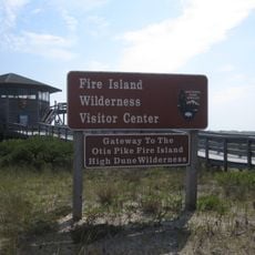
Smith Point County Park, Beachfront park on Fire Island, Suffolk County, United States.

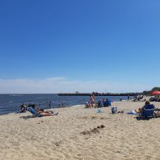
Smith Point County Park is a beachfront area on the Atlantic coast at the eastern end of Fire Island with white sand and rolling surf. The property includes developed camping facilities with utilities and an outer beach area for day visitors and overnight guests.

The name comes from William Smith, known as 'Tangier', who owned extensive coastal land in the Manor of St. George during the 1600s. The area was later developed as a public beach and camping destination.

The TWA Flight 800 International Memorial near the main pavilion honors the 1996 aviation disaster with flags representing the nationalities of those who were lost. Visitors can reflect at this memorial, which has become a place of remembrance for the community.

All camping sites require advance reservations and offer basic amenities for overnight stays. Weather and seasonal conditions can affect access to the outer beach area, so check conditions before planning your visit.

Hurricane Sandy created new water inlets within the park in 2012, triggering ongoing management and restoration efforts that continue today. These changes have reshaped the landscape and reveal the natural forces at work in coastal areas.

The community of curious travelers

AroundUs brings together thousands of curated places, local tips, and hidden gems, enriched daily by 60,000 contributors worldwide.

Start exploring
Location
GPS coordinates
40.73840,-72.84440
Latest update
December 10, 2025 15:56
Around this place
Long Island Central Pine Barrens
United States of America

Long Island Central Pine Barrens

12.9 km
National Synchrotron Light Source II
United States of America

National Synchrotron Light Source II

14.3 km
Gateway Playhouse
United States of America

Gateway Playhouse

7.9 km
National Synchrotron Light Source
United States of America

National Synchrotron Light Source

14.7 km
Wertheim National Wildlife Refuge
United States of America

Wertheim National Wildlife Refuge

4.8 km
Otis Pike Fire Island High Dune Wilderness
United States of America

Otis Pike Fire Island High Dune Wilderness

7.7 km
William Floyd House
United States of America

William Floyd House

3.9 km
Patchogue Theatre
United States of America

Patchogue Theatre

14.6 km
Long Island Game Farm
United States of America

Long Island Game Farm

13.1 km
Southaven County Park
United States of America

Southaven County Park

10.1 km
Smith Point Bridge
United States of America

Smith Point Bridge

2 km
Sandspit Park Beach & Marina
United States of America

Sandspit Park Beach & Marina

14.4 km
United States of America

Shorefront Park

13.8 km
Patchogue-Medford Library
United States of America

Patchogue-Medford Library

14.6 km
Mary E. Bell House
United States of America

Mary E. Bell House

8.6 km
Bellport Village Historic District
United States of America

Bellport Village Historic District

8.1 km
United States of America

Swan Lake Park

13 km
Mascot Dock
United States of America

Mascot Dock

14 km
Homan-Gerard House and Mills
United States of America

Homan-Gerard House and Mills

12.4 km
Suffolk County Almshouse Barn
United States of America

Suffolk County Almshouse Barn

11.9 km
Bellport Academy
United States of America

Bellport Academy

8.1 km
Robert Hawkins Homestead
United States of America

Robert Hawkins Homestead

10.8 km
Blue Point Beach
United States of America

Blue Point Beach

15.3 km
Smith-Rourke House
United States of America

Smith-Rourke House

11.6 km
Shirley Beach
United States of America

Shirley Beach

3.6 km
Masury Estate Ballroom
United States of America

Masury Estate Ballroom

5.7 km
Upper Lake
United States of America

Upper Lake

14.2 km
Cupsoque Beach
United States of America

Cupsoque Beach

9.4 km
Show the full map
Reviews
Share your experience

No review yet

Discussions
Start a discussion...

No discussion yet

« Smith Point County Park - Beachfront park on Fire Island, Suffolk County, United States » is provided by Around Us (aroundus.com). Images and texts are derived from Wikimedia project under a Creative Commons license. You are allowed to copy, distribute, and modify copies of this page, under the conditions set by the license, as long as this note is clearly visible.

Discover hidden gems everywhere you go!

From secret cafés to breathtaking viewpoints, skip the crowded tourist spots and find places that match your style. Our app makes it easy with voice search, smart filtering, route optimization, and insider tips from travelers worldwide. Download now for the complete mobile experience.

Around Us App Screenshot

A unique approach to discovering new places

Le Figaro

All the places worth exploring

France Info

A tailor-made excursion in just a few clicks

20 Minutes

Around Us
Travel Guide & Maps
Download

Send to your phone

QR Code
1

Open the camera app on your mobile.

2

Point at the QR code with your camera. A notification will appear.

3

Tap the notification to open the link.