Enable Location

We need your location to show you interesting places around you

Discover nearby places

Find interesting locations and hidden gems around you

Precise directions

Get accurate directions and distances to places

Your location is never shared with other users. It's only used when you tap the location button.

Wertheim National Wildlife Refuge

Log in to your account

Start exploring — it's free

Trusted by 62,454 travelers worldwide

Continue with Google
Continue with Apple
or

We will send you a code to connect

By continuing, you accept our Terms and Conditions and our Privacy Policy

Check your inbox

We've sent a pincode in your inbox. Please enter the code below.

Wertheim National Wildlife Refuge

Wertheim National Wildlife Refuge, Wildlife refuge in Long Island, United States

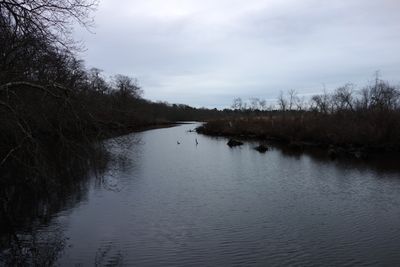
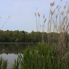
Wertheim National Wildlife Refuge is a protected area on Long Island's south shore that stretches along the Carmans River. The land contains oak and pine forests, open grasslands, and wetland areas that together create varied habitats for wildlife.

The refuge was founded in 1947 as part of the nationwide network of wildlife protection areas intended to safeguard critical habitats. Its creation came from the need to protect Long Island's natural resources from further loss and damage.

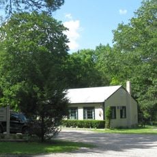
The visitor center displays exhibits about local ecosystems with interactive elements and dioramas showing the wildlife that lives here. These displays help guests understand what habitats different species need to survive in this region.

The refuge is accessible through six miles of hiking trails where visitors can observe and photograph wildlife. Most paths are flat and well-maintained, and the best time to explore is early morning when animals are most active.

The Carmans River flowing through the refuge is designated as a State Scenic Waterway and supports multiple fish species and water-dependent animals. This designation recognizes the river's special natural beauty and ecological importance to the region.

The community of curious travelers

AroundUs brings together thousands of curated places, local tips, and hidden gems, enriched daily by 60,000 contributors worldwide.

Start exploring
Location
Inception
1947
GPS coordinates
40.77500,-72.87470
Latest update
December 10, 2025 20:07
Around this place
Camp Siegfried
United States of America

Camp Siegfried

9.6 km
Long Island Central Pine Barrens
United States of America

Long Island Central Pine Barrens

10.6 km
National Synchrotron Light Source II
United States of America

National Synchrotron Light Source II

10.1 km
Gateway Playhouse
United States of America

Gateway Playhouse

5.1 km
National Synchrotron Light Source
United States of America

National Synchrotron Light Source

10.4 km
Otis Pike Fire Island High Dune Wilderness
United States of America

Otis Pike Fire Island High Dune Wilderness

8.4 km
William Floyd House
United States of America

William Floyd House

4.4 km
Patchogue Theatre
United States of America

Patchogue Theatre

11.7 km
Long Island Game Farm
United States of America

Long Island Game Farm

10.9 km
Southaven County Park
United States of America

Southaven County Park

5.3 km
Smith Point Bridge
United States of America

Smith Point Bridge

4.1 km
Sandspit Park Beach & Marina
United States of America

Sandspit Park Beach & Marina

12.2 km
United States of America

Shorefront Park

11.5 km
Smith Estate
United States of America

Smith Estate

10.7 km
Patchogue-Medford Library
United States of America

Patchogue-Medford Library

11.8 km
Mary E. Bell House
United States of America

Mary E. Bell House

7.8 km
Bellport Village Historic District
United States of America

Bellport Village Historic District

5.6 km
United States of America

Swan Lake Park

10 km
Mascot Dock
United States of America

Mascot Dock

11.8 km
Homan-Gerard House and Mills
United States of America

Homan-Gerard House and Mills

7.6 km
Suffolk County Almshouse Barn
United States of America

Suffolk County Almshouse Barn

7.1 km
Bellport Academy
United States of America

Bellport Academy

5.8 km
Robert Hawkins Homestead
United States of America

Robert Hawkins Homestead

6 km
Smith-Rourke House
United States of America

Smith-Rourke House

8.9 km
Masury Estate Ballroom
United States of America

Masury Estate Ballroom

5.7 km
Upper Lake
United States of America

Upper Lake

9.4 km
Brookhaven Free
United States of America

Brookhaven Free

3.1 km
Patchogue-medford Library
United States of America

Patchogue-medford Library

11.8 km
Show the full map
« Wertheim National Wildlife Refuge - Wildlife refuge in Long Island, United States » is provided by Around Us (aroundus.com). Images and texts are derived from Wikimedia project under a Creative Commons license. You are allowed to copy, distribute, and modify copies of this page, under the conditions set by the license, as long as this note is clearly visible.

Discover hidden gems everywhere you go!

From secret cafés to breathtaking viewpoints, skip the crowded tourist spots and find places that match your style. Our app makes it easy with voice search, smart filtering, route optimization, and insider tips from travelers worldwide. Download now for the complete mobile experience.

Around Us App Screenshot

A unique approach to discovering new places

Le Figaro

All the places worth exploring

France Info

A tailor-made excursion in just a few clicks

20 Minutes

Around Us
Travel Guide & Maps
Download

Send to your phone

QR Code
1

Open the camera app on your mobile.

2

Point at the QR code with your camera. A notification will appear.

3

Tap the notification to open the link.